III. GEOLOGIC PROBLEMS
The project site is located in the Petaluma Valley approximately 1,000 feet east of the Petaluma River. The site is underlain by unconsolidated fluvial deposits of generally fine but variable grain size composed mainly of fine sand, silt, and silty clay. Previous test borings at the site encountered 2 to 2 _ feet of asphalt pavement, base rock and fill consisting of sandy clay, clayey sand, and silty sand with cobbles (PG&E, 1998). Below the fill, a layer of stiff silty clay with lenses of silty sand was encountered to a depth of 15 feet. This is underlain by a layer of medium dense to dense silty sand with clay lenses to a depth of 21 feet. A sand and gravel layer with 10% to 15% fines was encountered between 21 and 26 feet. The sand and gravel was underlain by silty clay and sandy clay to the depths of the borings. Groundwater was encountered at a depth of 5 to 7 feet.
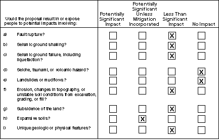
There are two APEFZ’s within southern Sonoma County: the Rodgers Creek Fault, approximately 4.7 miles northeast of the site, and the San Andreas Fault, approximately 15 miles southwest of the site. The Tolay Fault was previously designated within an APEFZ, but was removed in 1983 (City of Petaluma, 1995). The site is not within an APEFZ. According to the DMG (1994), there are no known or suspected active faults nearer to the site or projecting toward the site. The potential for concealed bedrock faults (e.g., an undetected low angle thrust fault) that could result in surface fault rupture is considered to be low at the site, and thus the hazards to people and the proposed facilities caused by fault rupture are considered to be a less-than-significant impact.
Damage to substations was a primary cause for loss of power in recent earthquakes such as the Loma Prieta Earthquake and Northridge Earthquake. The site is within Seismic Zone 4 (highest hazard) of the 1994 Uniform Building Code (UBC). Damage to substation facilities from groundshaking may not be entirely mitigable, however, compliance with the UBC for design and construction of the substation would reduce ground shaking effects on the facility to levels of acceptable risk and, therefore, result in a less-than-significant impact from ground shaking.
Groundshaking, and in some project areas liquefaction, could result in damage to power lines. The conductor wires are strung with sufficient length and catenary (sag) to accommodate vibratory motions and tensions set up by ground motions in earthquakes or high winds. In other words, it is considered a remote hazard that the power lines would "snap" because of earthquake groundshaking. On the other hand, earthquake induced vibratory motions in power lines have resulted in "wrapping" of the lines in which the separate conductor lines come into physical contact with each other. For example, wrapping was recorded as an effect of the 1989 Loma Prieta Earthquake. Wrapping is a potentially hazardous situation because the "hot wires" come into contact, although it would not likely cause the lines to break and fall. PG&E’s design and spacing requirements would be expected to be in conformance with requirements and industry standards for conductor separation.
The primary potential cause of failure of power lines would result from the failure of one or more of the poles supporting the conductors. Tubular steel poles are structurally extremely strong and able to resist earthquake induced vibratory motions (or high winds) without failure, as evidenced by their performance in the Loma Prieta Earthquake, the 1994 Northridge Earthquake, and other earthquakes. Bending or breaking of the poles would be a remote hazard. The hazard would be greatest from the tipping of a pole caused by liquefaction or lateral movement of the ground (see following discussion). For this area, the ground dislocations from liquefaction would be minor and within the amount that could be well accommodated by the pole and its foundation design. Because PG&E would employ construction measures for installation of poles and stringing of conductors that meet accepted design standards, the hazards related to groundshaking, while not entirely avoidable, would not constitute an unacceptable level of risk; therefore, the impact is deemed to be less than significant.
The site is underlain by a saturated sand and gravel layer at a depth of 21 to 26 feet that is potentially subject to liquefaction. This deposit is capped by stiff, cohesive soils, and it is likely that liquefaction-induced settlements would be small and within tolerable levels for the substation facilities. Project design using PG&E standard designs in accordance with CPUC General Order 95 would incorporate measures to consider potential liquefaction settlement and effects on structures (PG&E, 1998). Such measures would reduce the effects of potential liquefaction to levels of acceptable risk and result in a less than significant impact.
TABLE III-1
Known Active and Potentially Active Faults in Project Vicinity
|
Fault |
Study Area Distance from Fault (km) |
Maximum Credible Earthquake (1) |
Maximum Estimated Bedrock Acceleration (g) (2) |
|
Rodgers Creek |
5 |
7.0 |
0.38 |
|
San Andreas |
15 |
8.0 |
0.31 |
|
Hayward |
22 |
7.5 |
0.18 |
|
Green Valley |
25 |
7.0 |
0.11 |
|
Palo Colorado/ |
26 |
7.7 |
0.18 |
|
Concord |
32 |
6.7 |
0.07 |
|
Coast Range/ |
35 |
8.0 |
0.17 |
|
Antioch |
44 |
6.7 |
0.05 |
|
Calaveras |
48 |
7.5 |
0.08 |
|
Greenville |
50 |
7.3 |
0.07 |
Note: Distance shown is approximate, as measured from each end of the study area.
(1). Blake, 1995
(2). Average of Idriss (1994) and Campbell and Bozorgnia (1994)
The site is on a relatively flat slope (very gently sloping) and is approximately 1,000 feet away from the Petaluma River Channel, which is the nearest significant embankment to the site. The potential for lateral spreading and ground lurching is considered to be low due to the relatively large distance to the channel embankment. The test borings did not encounter loose, unsaturated sands subject to densification. The potential for lateral spreading, ground lurching, and densification is considered to be less than significant.
Grading and construction activities would disturb site soils. The soils may be subject to erosion from rainfall and stormwater runoff during periods of precipitation. Because the site is nearly level, construction activities are not likely to result in heavy erosion, gullying, or sedimentation, and are not considered to be a significant hazard.
TOP
| Forward to Next Section (Water) |
Back to Previous Section (Population and Housing) |
Back to Corona Substation Main Page | PG&E Substation Projects Main Page | CPUC Home Page |