SECTION 4
ENVIRONMENTAL CHECKLISTS
4.13 AESTHETICS
SETTING
Regional Setting
The 12 power plants are located along the California coastline or inland within San Bernardino County. Coastal areas are generally highly sensitive to visual impacts. Coastal landscapes are typically open, affording clear views over the range of viewing distances from the immediate foreground to the horizon. Land forms and patterns (e.g., the curve of the shoreline itself) are often distinctive in their forms, colors, and textures; small changes in existing landscape elements or the introduction of features that are modest in scale may be visually prominent or disruptive. Desert and inland landscapes in San Bernardino County, while not as visually sensitive as many coastal areas, are typically open and provide few natural features, such as mature vegetation or hills, that screen industrial sites.
With the exception of the Ellwood Energy Support Facility, which is housed in a one-story Spanish-style stucco building, all of the generating stations are typically large-scale, regular and simple in form, and without decorative architectural treatments and exterior ornament. Structural and operating system components (e.g., framing members and pipes) are open to view. Building materials are predominantly steel and concrete, and colors and exterior finishes are flat and subdued.
Local Setting
The following local setting information was obtained from the Technical Resources Document prepared by Entrix, Inc. (1996).
Alamitos
The Alamitos power plant is located on a 234-acre site in the southeastern portion of the City of Long Beach. The station contains seven power generating units and related facilities that are industrial in character, as well as office buildings and storage areas. Surrounding land uses include residential, commercial, retail, office, hotel, and light industrial development. The smokestacks of the Haynes Generating Station, located across the San Gabriel River from the Alamitos facility, are a dominant visual feature.
The Alamitos plant occupies a flat, open area between the Los Cerritos Channel and the San Gabriel River, immediately adjacent to large tracts of undeveloped land and oil fields within the Port of Long Beach and the U.S. Naval Shipyard. Storage tanks are highly visible from surrounding areas and contribute to the overall utilitarian, industrial character of the site. Portions of the facility rise approximately 150 feet above ground, dominating background views from surrounding roadways and neighborhoods. Exterior finishes are subdued shades of gray, blue, green, and brown that are intended to reduce visual contrast with the landscape. A web of transmission lines crosses the plant site. Landscaping located along the perimeter of the site partially screens the facilities. From areas west of the Los Cerritos Channel, the Alamitos facilities blend with the generating units and stacks of the Haynes Generating Station across the San Gabriel River.
Views of the Alamitos plant are available from State Route 22, Westminster Avenue, Studebaker Road, and the bicycle trail along the San Gabriel River. No designated scenic routes are located in the site vicinity.
Cool Water
The Cool Water power plant is located on a 2,395-acre site in the unincorporated community of Daggett, a remote, sparsely populated desert area of San Bernardino County. Facilities at the site include four power generating units, retention basins, and cooling towers, as well as an office building, training center, maintenance shop, and equipment storage. Several large tanks are highly visible near the southern end of the generating station. Exterior finishes are subdued shades of olive green, gray, and gold that are intended to blend with the surrounding desert landscape. The site is primarily level and is surrounded by low-lying uses such as a solar generating project, open space, and agricultural fields. Chain-link fencing, sparsely lined with shrubs and trees, surrounds the site.
The overall visual character of the site vicinity is determined by the forms, colors, and patterns of the desert landscape. Broad, flat expanses of desert and agricultural fields in the foreground merge with the rugged mountains that form the background. A transmission line that traverses the area in a northeast-southwest direction is a dominant visual feature. The generating station is visible from nearby residences and Interstate 40. No scenic routes are located within the site vicinity.
Ellwood
The Ellwood power plant is located on a 3.5-acre site in the unincorporated community of Goleta in Santa Barbara County. The visual character of this area is influenced by its position on a coastal terrace at the foot of the rugged Santa Ynez Mountains. Plant facilities at the Ellwood site include one power generating unit, a small building, and a maintenance shop. The site, which is generally level, is housed within a single-story structure that exhibits characteristics of residential buildings in its architecture and exterior details (e.g., stucco walls, red tile roof). Painted wrought iron fencing and vegetation partially screen the facility. Land uses surrounding the Ellwood site include open space and suburban residential and commercial development.
The undeveloped open space of the Santa Barbara County Parks Department property dominates views to the south, while views to the southwest and west of the site include the Sandpiper Golf Course and an undeveloped property across Armas Road. Views of the Ellwood site are available from U.S. Highway 101, which is identified in the County Comprehensive Plan as eligible for state scenic highway designation, and from Hollister Avenue. Views of the site from other vantage points are obscured by distance and the trees surrounding both the energy support facility and the nearby parking lot.
El Segundo
The El Segundo power plant is located on a 33-acre oceanfront site in the City of El Segundo in Los Angeles County. El Segundo is part of an urban region that is bordered on the west by the Pacific Ocean and on the north by Los Angeles International Airport. Facilities at the site include four power generating units, retention basins, and a cooling system. Portions of the structures are approximately 150 feet high and are dominant visual features in westerly views from Vista Del Mar. In addition, each of the four generating units is approximately 100 feet tall, and an adjacent smokestack stands 150 feet high. Exterior finishes are subdued shades of beige and blue-green that are intended to blend with the surrounding landscape. Land uses in the site vicinity include a Chevron oil refinery to the east, a generating station operated by the Los Angeles Department of Water and Power to the north, Manhattan Beach State Park to the south, and Dockweiler Beach State Park to the west.
Views of the site are available from public recreation areas, including Manhattan Beach State Park and Dockweiler Beach State Park; from nearby residences; and from Vista Del Mar. The site is partially screened by a landscaped buffer along the western side of Vista Del Mar. No scenic routes are located in the site vicinity.
Etiwanda
The Etiwanda power plant is located on a 209-acre site in the City of Rancho Cucamonga in San Bernardino County. Facilities at the site include five power generating units, retention basins, and a cooling system, as well as an office building, maintenance shop, and a warehouse. The visual character of the site vicinity is defined primarily by the flat topography and surrounding industrial uses to the north, east, and south. To the west, agricultural uses are visible in the foreground. Background views are dominated by the San Gabriel Mountains to the north of the city.
Storage tanks located in the southern portion of the Etiwanda site are highly visible in views from the southwest and east. A tall earthen berm screens views of the site from Sixth Street. The generating units and adjacent stacks are painted beige to minimize contrast with surrounding areas. Black bands of paint are visible at the tops of the smokestacks. The site is enclosed by a chain-link fence, with a landscaped area, berm, and mature trees partially screening views of the site from Etiwanda Avenue. The station is visible from Interstate 10 to the south as well as adjacent roadways. No designated scenic routes are located within the site vicinity.
Highgrove
The Highgrove power plant is located on a 79-acre site in the City of Grand Terrace in San Bernardino County. Facilities at the site include four power generating units, retention basins, a cooling system, and two office buildings. Large tanks at the north end of the site are partially visible through a stand of mature trees that extends along the west side of Taylor Street. Some of the structures on the site are approximately 150 feet high and are dominant visual features in westerly views from nearby open areas. Intervening vegetation and development screen views of the site from these areas. Two of the four generating units are approximately 100 feet tall, and an adjacent smokestack stands about 150 feet tall. Exterior finishes are subdued shades of beige and green to minimize contrast with the surrounding landscape. Chain-link fencing and mature trees and hedges located along the perimeter of the site partially screen station facilities.
The visual character of the site vicinity is primarily rural and suburban. Agricultural uses dominate foreground views east of the site, while a mixture of industrial and commercial development occupies the foreground of views to the north, west, and south. The Box Spring Mountains, Jurupa Mountains, and La Loma Hills form the background in views to the east, northwest, and west, respectively.
Views of the Highgrove plant are available from Pico Park and nearby residences. No scenic roadways are designated within the City of Grand Terrace.
Huntington Beach
The Huntington Beach power plant is located on a 106-acre site in the City of Huntington Beach. Facilities at the site include five power generating units, retention basins, a cooling system, an office building, a maintenance shop, and a warehouse. The station lies within the Edison Sanitation District, which is characterized by large, isolated industrial plant facilities with conspicuous structures and security fencing. The station's six tanks, ranging in diameter from 72 to 300 feet and approximately 40 feet in height, and four 100-foot-tall power generating units are highly visible from vantage points throughout the site vicinity. Exterior finishes are beige and blue-green to blend with the surrounding landscape. The site is partially screened by a landscaped buffer that extends along Newland Avenue, the Pacific Coast Highway, and the southern site boundary. The City of Huntington Beach considers views of the generating station to contribute negatively to the community's identity.
The site vicinity is primarily characterized by industrial and open space uses. Views of the Huntington Beach Generating Station are available from Huntington State Beach and the Pacific Coast Highway, which is designated as eligible for state listing as a scenic highway. Views of the site are also available from open space areas and nearby residential, commercial and industrial uses.
Long Beach
The Long Beach power plant is located on a 43-acre site in the City of Long Beach. Facilities at the site include nine power generating plants, retention basins, a cooling system, an office building, and a maintenance shop. The station is situated within the Port of Long Beach, which is characterized by industrial land uses such as railroad lines, cranes, open storage lots, and warehouses. The limited number of structures in the immediate vicinity of the site increases the visibility of station facilities, which have tan and brown exteriors to blend with surrounding areas. A concrete wall surrounds the storage tanks, partially screening them from view. Fences and mature vegetation also provide some screening.
Views of the Long Beach plant are available from nearby roadways such as Ocean Boulevard and the Terminal Island Bridge within the Port of Long Beach. No scenic routes are located in the site vicinity.
Mandalay
The Mandalay power plant is located on a 205-acre site next to the Pacific Ocean in the City of Oxnard. Facilities at the site include three power generating units, retention basins, five storage tanks, a cooling system, an office building, and a warehouse. The five tanks, which range in diameter from 58 to 200 feet and in height from 40 to 56 feet, are highly visible from adjacent properties. An asphalt-covered berm surrounds the tanks south of the generating units. Some structures on the site are over 100 feet above the dunes and dominate views from the surrounding area. The top one-third of the smokestack adjacent to the two generating units is painted with red and white horizontal stripes; the lower two-thirds is painted beige. Exterior finishes on the rest of the facilities are beige and blue-gray, and are intended to blend with the surrounding landscape. A landscaped buffer extends along Harbor Boulevard and combines with the rolling terrain of the surrounding dunes to partially conceal the smaller structures of the facility. Transmission lines extending from the site stand out from the surrounding flat topography. Surrounding land uses include agricultural lands and open space.
Views of the Mandalay plant are available from Fifth Street, which is designated as a scenic route by the City of Oxnard. Views of the station are also available from residences south of Fifth Street and from McGrath and Mandalay State Beaches.
Ormond
The Ormond power plant is located on a 693-acre site within the City of Oxnard, between the Pacific Ocean and agricultural lands. The site is located in an area primarily characterized by agricultural and industrial uses. Existing facilities at the site include two power generating units, retention basins, six fuel oil tanks, an ocean-fed cooling system, an office building, a shop, and a warehouse. The six fuel oil tanks, which are 273 feet in diameter and stand 48 feet high, and a 40-foot-tall cutter stock tank are visible from nearby roads, but blend in with the surrounding flat topography due to their relatively low, wide profiles and beige color. Other facilities, including the smokestacks adjacent to the power generating units, are up to 150 feet tall and dominate views from surrounding areas. Both of the generating units are approximately 100 feet tall, and an adjacent smokestack is 150 feet tall. The generating units are painted a shade of blue-green that blends with the ocean background, and the adjoining stacks are primarily beige, with red and white horizontal stripes at the top. Vegetation and fencing partially screen some of the facilities.
Views of the Ormond plant are available from nearby agricultural and industrial uses; few sensitive receptors are located in the area near the site. No designated scenic routes are located in the site vicinity.
Redondo
The Redondo power plant is located on a 56-acre site in a highly urbanized region within the City of Redondo Beach, adjacent to the Pacific Ocean. Surrounding land uses include residential, commercial, and light industrial uses. The generating station is situated on the relatively flat oceanfront and dominates views from surrounding areas. Facilities at the site include eight power generating units, fuel oil tanks, retention basins, three ocean-fed cooling systems, an administration building, and a small satellite building. A landscaped buffer that extends along the east side of Harbor Drive partially screens the site from ground-level vantage points to the west within King Harbor. An earthen berm fully screens the southernmost fuel tank. The southern and western sides of two of the power generating units are screened by the 622-foot-long, 100-foot-tall Whaling Wall mural, painted by internationally known artist Wylan, which extends along the western site boundary and Harbor Drive and depicts a life-size panorama of ocean life, including 13 whales. The Whaling Wall covers approximately one-third of the site's western wall; the remaining length of the station's western facade consists of 100-foot high, beige concrete walls that screen the other six power generating units. In views from the east, the site is visually compatible with surrounding industrial uses. The station facilities and transmission lines dominate the background of southwesterly views from uphill areas along Herondo Street.
Views of the Redondo plant are available from residences to the north, south, and east; from recreational and tourist amenities in the King Harbor area; and from Harbor Drive and Herondo Street. No designated scenic routes are located in the site vicinity.
San Bernardino
The San Bernardino power plant is located on a 103-acre site in San Bernardino County, just outside of the City of San Bernardino. The site occupies a flat area surrounded by residential and industrial development on the west, open space on the north, and agricultural areas on the remaining sides. Interstate 10 and the Box Spring Mountains form the background in easterly and southerly views. To the north, the San Gabriel and San Bernardino Mountains compose the background. Facilities at the site include two power generating units, retention basins, storage tanks, smokestacks, a cooling system, an administration building, and a warehouse. The tanks at the southern end of the site are highly visible from the southwest and east. An earthen berm that surrounds the tanks partially screens views of these structures from Mountain View Avenue. Exterior finishes are beige and gray to reduce visual contrast with surrounding areas. Black bands of paint are visible at the top of the smokestacks. A chain-link fence encircles the site.
Views of the San Bernardino plant are available from residences to the southwest and from nearby roadways. No designated scenic routes are located in the site vicinity.
CHECKLIST ISSUES
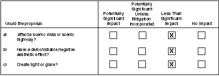
a) Scenic Vistas and Scenic Highways
Alamitos
No designated scenic routes are identified in the vicinity of the Alamitos power plant, and station facilities are not prominent in any scenic vistas. The existing facilities at the site are visually compatible with the Haynes Generating Station located across the San Gabriel River. The Alamitos facility is located within the Coastal Zone, and thus any future development would be subject to the policies of the Local Coastal Program, which encourages the protection of scenic views within the Coastal Zone. The only anticipated physical modifications of the plant from the project would be to construct a fence to separate the divested property from the retained property, and any associated access improvement. This would not substantially alter the appearance of the site, and would not be considered a significant adverse impact. Additionally, the site is not prominent in scenic views or vistas, and is not visible from any designated scenic highway. Therefore, the impact on scenic vistas and highways would be less than significant.
Cool Water
The Cool Water power plant is visible in views from nearby residences and Interstate 40. No designated scenic routes are located in the vicinity of the Cool Water site, and plant facilities are not prominent in any scenic vistas. Furthermore, no substantial modifications at the Cool Water plant are foreseeable; therefore, potential impacts on scenic vistas and highways would be less than significant.
Ellwood
The Ellwood power plant is visible from U.S. Highway 101, which has been identified as eligible for state scenic highway designation in the Santa Barbara County Comprehensive Plan. The only anticipated physical modifications of the plant from the project would be to construct a fence to separate divested properties from the retained properties. The project would not result in any substantial foreseeable modifications at the Ellwood facility that could adversely affect scenic views from the highway. Therefore, the impact on scenic vistas and highways would be less than significant.
El Segundo
The El Segundo power plant is visible from vantage points within Manhattan Beach State Park and Dockweiler Beach State Park. In addition, the El Segundo station is located within the Coastal Zone, and thus is subject to the policies of the Local Coastal Program, which encourages the protection of scenic views within the Coastal Zone. The only anticipated physical modifications of the plant from the project would be to construct a fence to separate the divested property from the retained property, and any associated access improvements. This would not substantially alter the appearance of the site, and would not be considered a significant adverse impact. Therefore, the impact on scenic vistas and highways would be less than significant.
Etiwanda
The Etiwanda power plant is visible in views from nearby roads, including Interstate 10. No designated scenic routes are identified in the vicinity of the Etiwanda site, and station facilities are not prominent in any scenic vistas. The only anticipated physical modification of the plant from this project would be to construct a fence to separate the divested property from the retained property. This would not substantially alter the appearance of the site; and would not be considered a significant adverse impact. Therefore, the impact on scenic vistas and highways would be considered less than significant.
Highgrove
The Highgrove power plant is visible in views from nearby residences and Pico Park. No designated scenic routes are identified in the vicinity of the Highgrove site, and station facilities are not prominent in any scenic vistas. The only anticipated physical modifications of the plant from this project would be to construct a fence to separate the divested property from the retained property, and any associated access improvements. This would not substantially alter the appearance of the site, and would not be considered a significant adverse impact. Therefore, the impact on scenic vistas and highways would be less than significant.
Huntington Beach
The Huntington Beach power plant is visible in views from the Pacific Coast Highway, which is eligible for state listing as a designated scenic highway, as well as from Huntington State Beach. In addition, the Huntington Beach station is located within the Coastal Zone, and thus is subject to the policies of the Local Coastal Program, which encourages the protection of scenic views within the Coastal Zone. Because the project would not result in any substantial foreseeable modification to the existing facilities, the project would not adversely affect scenic views from Huntington State Beach or the Pacific Coast Highway. In this sense, the project would not be inconsistent with Local Coastal Program policies. Therefore, the impact on scenic vistas and highways would be less than significant.
Long Beach
The Long Beach power plant is visible from nearby roadways, such as Ocean Boulevard and the Terminal Island Bridge, as well as from vantage points within the Port of Long Beach. No designated scenic routes are located within the station vicinity. However, the Long Beach station is located within the Coastal Zone, and thus is subject to the policies of the Local Coastal Program, which encourages the protection of scenic views within the Coastal Zone. The only anticipated physical modifications of the plant from the project would be to construct a fence to separate the divested property from the retained property, and any associated access improvements. This would not substantially alter the appearance of the site, and would not be considered a significant adverse impact.
Mandalay
The Mandalay power plant is visible from Fifth Street, which has been designated as a scenic route by the City of Oxnard. Views of the station are also available from McGrath and Mandalay State Beaches. The Mandalay station is located within the Coastal Zone, and thus is subject to the policies of the Local Coastal Program, which encourages the protection of scenic views within the Coastal Zone. Because the project would not result in any substantial foreseeable modification to the existing facilities, the project would not adversely affect scenic views from the Fifth Street or nearby state beaches, or be inconsistent with Local Coastal Program policies. Therefore, the impact on scenic vistas and highways would be less than significant.
Ormond
The Ormond power plant is visible from nearby agricultural and industrial uses. No designated scenic routes are identified in the vicinity of the Ormond site, and station facilities are not prominent in any scenic vistas. Furthermore, no substantial modifications to the Ormond facility are foreseeable; therefore, potential impacts on scenic vistas and highways would be less than significant.
Redondo
The Redondo power plant is visible from Harbor Drive, Herondo Street, and from recreational and tourist amenities in the King Harbor area. No designated scenic routes are identified in the vicinity of the Redondo station. The only anticipated physical modifications of the plant from the project would be to construct a fence to separate the divested property from the retained property, and any associated access improvements. This would not substantially alter the appearance of the site, and would not be considered a significant adverse impact. Therefore, the impact on scenic vistas and highways is considered potentially significant.
San Bernardino
The San Bernardino power plant is visible from nearby roads and residences. No designated scenic roadways are located in the vicinity of the San Bernardino site, and station facilities are not prominent in any scenic vistas. The only anticipated physical modifications of the plant from the project would be to construct a fence to separate the divested property from the retained property, and any associated access improvements. This would not substantially alter the appearance of the site, and would not be considered a significant adverse impact. Therefore, the impact on scenic vistas and highways would be less than significant.
Conclusion
The project would not result in substantial visible changes to any of the plants. Therefore, the impacts would be less than significant.
b) Negative Aesthetic Effects
The only anticipated physical modifications of the plants from the project would be to construct a fence to separate the divested property from the retained property, and any associated access improvements. This would not substantially alter the appearance of the sites, and would not be considered a significant negative aesthetic effect. Therefore, , the project would not result in a potentially significant impact.
Conclusion
The project would not result in substantial visible changes to any of the plants. Therefore, the impacts would be less than significant.
c) Light and Glare
Combined Effects
Substantial modifications at many of the 12 Edison properties are not foreseeable, and the minor construction activities at the plants anticipated for the project would not introduce additional sources of reflected sunlight and glare to these site vicinities.
Conclusion
The only anticipated physical modifications of the plants from the project would be to construct a fence to separate the divested property from the retained property, and any associated access improvements. These modifications would not introduce sources of light and glare. Therefore, the impact would be less than significant.