SECTION 4
ENVIRONMENTAL CHECKLISTS
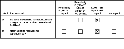
4.15 RECREATION
SETTING
Alamitos
The Alamitos power plant is in a development area in the City of Long Beach governed by the South East Area Development and Improvement Plan (SEADIP). The SEADIP program is an integrated specific plan for the continuing development of this area of the City of Long Beach. The SEADIP area is located near the mouth of the San Gabriel River, and much of the area has direct access to waterways that lead to the ocean.
The City of Long Beach maintains 7.0 acres of park land per 1,000 population for a total of 2,527 acres of park land. In addition, Long Beach has approximately 275 acres of beach that extend for 6.7 miles along the ocean front, Alamitos Bay, and Marine Stadium. The ratio of park lands to population is relatively high in the City of Long Beach, compared to many urbanized communities.
Cool Water
The Cool Water power plant is located in an undeveloped area in the County of San Bernardino. The facility includes a generating complex with approximately 700 acres of cropland and approximately 1,900 acres of open space.
Most of the High Desert Park District is publicly owned and under the jurisdiction of the U.S. Bureau of Land Management or Department of Defense. The Mojave River transects the region. No recreation facilities are in the immediate vicinity of the power plant. The County of San Bernardino Department of Parks and Recreation provides park and recreation services at county-owned facilities.
The power plant is in the Barstow Subregional Recreation Planning Area of the Desert Region in the county general plan and in the High Desert Park Planning District in the regional parks department plan. San Bernardino County maintains open space in the Desert region to promote tourism, preserve the Mojave River and Mojave Desert, provide outdoor activities, preserve cultural resources, and provide educational opportunities. Although the county contains vast open space areas, the majority of county residents live in the relatively urbanized valley regions. Most of the county's large open space areas in the Desert region are inaccessible to the majority of San Bernardino County occupants.
The Open Space Element of the San Bernardino County General Plan describes a valuing system that provides an objective measure of the relative value of land for open space uses. The open space element addresses trails, preservation of natural resources, managed production of resources, recreation, scenic resources, and public health and safety.
Ellwood
The Ellwood power plant is located in the community of Goleta, 3 miles northwest of the University of California, Santa Barbara campus (UCSB), and 1 mile north of the Pacific Ocean. A l-mile stretch of open space separates the Ellwood power plant from the Pacific Ocean. Ellwood Elementary School is adjacent to the power plant.
The County of Santa Barbara Parks and Recreation Department provides park and recreation services at county-owned facilities within the county. In addition, several facilities within the vicinity of the Ellwood power plant are owned or operated by other jurisdictions, such as the State of California.
Existing park facilities near the Ellwood power plant consist of approximately 40 acres of neighborhood park land.
A variety of open space areas exist in the vicinity of the Ellwood power plant, including the Santa Barbara Shores parcel that is 0.5 mile south of the power plant. The Santa Barbara Shores property is south of the existing Ellwood Beach and Santa Barbara Shores subdivisions off of Ellwood Beach. The site contains beach cliffs, vernal pools, and a large eucalyptus grove that harbors monarch butterflies. Coal Oil Point Ecological Preserve is an ecological preserve and dune habitat designed to protect sensitive biological organisms.
Open space is managed by the county parks department. A total of 59 open space locations are listed in the Goleta EIR, accounting for 230 acres. Currently, Goleta does not possess a major system of dedicated public trails that offer access to the National Forest and the ocean.
The Goleta planning area includes approximately 15 miles of coastline. Public access is somewhat limited due to the presence of steep bluffs and limited vertical access in some areas.
The Santa Barbara County General Plan specifies facility standards for a variety of recreational uses, including passive and active recreation activities. The standard park to population ratio is 4.7 acres per 1,000 persons. The number of trail miles for riding and hiking paths is not quantified. The Goleta Community Plan requires open space to be dedicated as a condition of approval for residential subdivisions.
El Segundo
The El Segundo power plant is located along the Pacific Coast in the City of El Segundo, adjacent to Dockweiler Beach State Park. The City of El Segundo is a highly developed industrial and suburban residential area. The city's open space and recreation resources consist mostly of public parks and other recreation facilities.
According to the City of El Segundo General Plan, the city maintains a park land to population ratio of 5.9 acres per 1,000 population. There are no public park facilities in the eastern portion of the city because there are no residential uses in this area.
Public recreation facilities in the City of El Segundo include nine public parks, three school sites, a utility transmission corridor, a golf driving range, a wildlife preserve, a recreation facility, and a beach area, encompassing a total of 91.0 acres of open and recreational space. The privately owned facilities include three parks, two utility transmission corridors, and three recreational facilities. Private facilities account for 102.7 acres.
Open space areas in the vicinity of the El Segundo power plant are limited to several utility right-of-way corridors, as well as beaches and a 3-acre wildlife preserve. The LADWP transmission corridor consists of 32 acres of land, and the Edison utility right-of-way encompasses a 10-acre area; these rights-of-way have been developed into park land corridors.
The entire shoreline area in the vicinity of the El Segundo power plant is designated as state beach. Dockweiler Beach State Park is managed by the State of California Department of Parks and Recreation. In addition, the nearby beach area has a coastal bike trail that is maintained by the County of Los Angeles.
The city has a fenced 1.6-acre wildlife preserve that provides habitat for the El Segundo blue butterfly (Shyimiaeoides battoides allyni, a federally listed endangered species.
The City of El Segundo has adopted a 5 acres per 1,000 population standard ratio for park land, which exceeds the Subdivision Map Act standard of 3 acres per 1,000 population. In addition, the City requires new industries with over 9,000 employees to provide recreation facilities for the daytime employee population.
Etiwanda
The Etiwanda power plant is located in San Bernardino County, in the southeastern edge of the City of Rancho Cucamonga within the city limits. The City of Rancho Cucamonga currently has 300 acres of park land, of which 165 acres have been developed.
There is limited open space in the vicinity of the Etiwanda power plant. Directly north of the site is a narrow strip of utility corridor. The northern portion of the city has more extensive open space areas that are not in the vicinity of the power plant.
The City of Rancho Cucamonga has adopted a park land standard of 5 acres per 1,000 population.
Highgrove
The Highgrove power plant is located within a development area of the City of Grand Terrace designated as Light Industrial. The power plant is in the Central Valley Park Planning District of the San Bernardino County Regional Parks Department under the jurisdiction of San Bernardino County.
Parks and recreation facilities in the City of Grand Terrace are primarily provided by the City's Community Services Department. Existing park facilities in the vicinity of the Highgrove power plant consist of approximately 17 acres of neighborhood and community park land, and 19 acres of elementary and junior high school properties managed by the Colton Unified School District.
A variety of open space areas exist within the City of Grand Terrace; however, there are no open space areas in the vicinity of the Highgrove power plant. A 139-acre area in the eastern section of the City of Grand Terrace is designated as open space. Open space is maintained for recreational, aesthetic, and habitat conservation purposes as well as slope stability and fire management.
The City of Grand Terrace General Plan specifies facility standards for a variety of athletic recreational uses. The standard park to population ratio is 4 acres per 1,000 population.
The San Bernardino County Regional Parks Department Strategic Master Plan identifies a standard of 2.5 acres of developed park land per 1,000 population and 14.5 acres of open space and trails per 1,000 population.
Huntington Beach
The Huntington Beach power plant is located adjacent to the Huntington State Beach Recreation area in the City of Huntington Beach, Orange County.
The City of Huntington Beach contains extensive and diverse opportunities for recreation. In 1993, Huntington Beach contained 71 non-coastal parks, encompassing 575.28 acres. These include four mini parks totaling 1.7 acres, 58 neighborhood parks (2.5-5 acres) totaling 157.39 acres, seven community parks (10-20 acres, with active uses) totaling 143.28 acres, one 300-acre community park (Central Park), and one regional park (Bolsa Chica Linear Regional Park - in progress) totaling 106 acres. Other regional facilities adjacent to Huntington Beach include Sunset Aquatic Park in Fountain Valley (95 acres with 260 boat slips) and Mile Square Park in Fountain Valley (632 acres).
The city has three golf courses: the public Driftwood Country Club, public Meadowlark golf course, and private Seacliff Country Club. Huntington Beach is equipped with equestrian facilities, including a 25-acre equestrian center and approximately 3-4 miles of horse trails.
The city's 9 miles of uninterrupted coastline include Bolsa Chica and Huntington State Beaches and Huntington City Beach, which encompass 380 acres. Four other beaches in Huntington Harbor provide additional recreational opportunities. Huntington Harbor, a 680-acre residential development, is oriented around a network of manmade channels located in the northwest corner of the City. Huntington Harbor contains four channel beaches and a total of 2,289 boat slips. Other public recreational opportunities include approximately 110 miles of bicycle trails, school playgrounds, and a community college facility.
The City of Huntington Beach Recreation and Parks Division provides park and recreation services at city-owned facilities within the City of Huntington Beach. Huntington State Beach is managed by the California Department of Parks and Recreation.
A variety of open space areas exist in the vicinity of the Huntington Beach power plant. These include two designated Conservation/Open Space areas. These two parcels total approximately 20 acres and are located southeast and northwest of the generating site. The Conservation designation is intended to protect valuable resource areas in the coastal zone from most types of development. The designation allows only certain low-intensity activities and public access, so long as the resources being protected are not impaired. Such support areas could include picnic and observation areas, nature trails and peripheral bicycle paths, informal signs or displays, and peripheral parking areas.
The City of Huntington Beach identifies a park standard of 5 acres per 1,000 people.
Long Beach
The Long Beach power plant is located in the Northwest Harbor District of Long Beach Harbor adjacent to the Los Cerritos Channel on Terminal Island. Most of the property in this district is privately owned; and the site is surrounded by industrial uses, including oil production and a naval ship yard.
The City of Long Beach maintains 7 acres of park land per 1,000 population for a total of 2,527 acres of park land. In addition, Long Beach has approximately 275 acres of beach that extend for 6.7 miles along the ocean front, Alamitos Bay, and Marine Stadium.
The Harbor Area Open Space Node encompasses a variety of land uses thinly scattered over the southwest corner of the city. The node is bisected by Los Cerritos Channel and includes part of Terminal Island.
Mandalay
The Mandalay power plant is located in the City of Oxnard in Ventura County. The station is located between McGrath State Beach to the north and Mandalay State Beach to the south. The Mandalay Generating facility occupies approximately 1,800 feet of ocean frontage.
The coastal zone includes numerous opportunities for public access to the ocean and related recreational uses. Broad sandy beaches, a harbor, the Inland Waterway, and the Edison Canal provide for a variety of coastal recreational activities. Oxnard's beaches constitute a substantial undeveloped recreational resource of local and state-wide significance. Approximately 8.5 miles of shoreline have been identified as major beach or recreational areas. The recreation value of beaches and their contribution to the county tourist industry is significant. Substantial potential exists for public access in the McGrath State Beach. Lateral beach access is obstructed by the Mandalay power plant's ocean outfall, which is located in the middle of Edison's ocean frontage. However, an 80-foot partially improved right-of-way for Mandalay Beach Road traverses Edison's property. While no agreement has been made concerning the exact nature of public rights to the beach, historic public use indicates that public prescriptive rights exist for this beach.
Ventura County maintains open space for a variety of reasons, including enhanced tourism, outdoor recreation opportunities, protection of natural resources, and erosion control. Open space areas in the vicinity of the Mandalay power plant include McGrath and Mandalay state beaches.
The City of Oxnard currently has a recommended service density of 3 acres of park land per 1,000 population.
Ormond Beach
The Ormond Beach power plant is located on a 691-acre site within the Ormond Beach Coastal Zone.
The coastal zone includes numerous opportunities for public access to the ocean and related recreational uses. Broad sandy beaches, a harbor, the Inland Waterway, and the Edison Canal provide for a variety of coastal recreational activities. Oxnard's beaches constitute a substantial undeveloped recreational resource of local and statewide significance. Approximately 8.5 miles of shoreline have been identified as major beach or recreational areas. The recreation value of beaches and their contribution to the county tourist industry is significant. The Ormond Beach study area in the south portion of the City consists of approximately 2,780 acres of land with about 168 acres of beach frontage. Approximately 2,300 acres are outside the City's existing sphere of influence. The area also includes 345 acres within the Coastal Zone. This beach is currently under-utilized because of its remoteness from main travel routes, proximity to industrial uses, and fragmented ownership. The remainder of the area currently is under agricultural production and devoted to heavy industrial uses generally related to port facilities and activities.
Ventura County maintains open space to enhance tourism, provide outdoor recreation opportunities, protect natural resources, and maintain erosion control. Open space areas in the vicinity of the Ormond Beach power plant include Ormond Beach, farmlands, and wetlands.
The City of Oxnard currently has a recommended service density of 3 acres of park land for 1,000 population.
Redondo
The Redondo power plant is located along the Pacific Coast in Los Angeles County. The city limits of Hermosa Beach border the property; however, the power plant is under the jurisdiction of the City of Redondo Beach, which provides a variety of recreational facilities and activities for residents and visitors.
The City of Redondo Beach contains diverse opportunities for recreation. The Redondo Beach park system includes 56.77 acres of city parks, 32.58 acres of school acreage, 3.55 acres of parkettes, 1.76 acres of multi-purpose play fields, and 72.35 acres of camping and nature parks.
A variety of open space areas exist in the vicinity of the Redondo power plant. Some open space areas include camp grounds, beaches, and the ocean. Open space in the City of Redondo Beach and the neighboring City of Hermosa Beach are maintained to improve and enhance the overall quality of life and attractiveness of the cities and to provide habitat for biological organisms. These open spaces serve a variety of recreational purposes, including surfing, biking, and camping.
San Bernardino
The San Bernardino power plant is outside the city limits of San Bernardino in San Bernardino County. Farms are on the south and east, industrial uses are on the west, and the Santa Ana River channel is approximately 500 feet north of the power plant.
The Open Space Element of the San Bernardino County General Plan describes a valuing system that provides an objective measure of the relative value of land for open space uses. The open space element addresses trails, preservation of natural resources, managed production of resources, recreation, scenic resources, and public health and safety.
CHECKLIST ISSUES
a) Demand for Parks and Other Recreational Facilities
Alamitos
According to the City of Long Beach Department of Parks and Recreation, the SEADIP neighborhood is a well-served recreational area. The department has proposed seven additional boat marinas in Marina Park and is currently constructing two new community parks (Fieldstone and Costa Del Sol Recreational Parks). The department considers this area to have good access to swimming beaches, marine space, bicycle paths, and other recreational opportunities.
Although the existing parkland to population ratio is relatively high in the City of Long Beach compared to other communities, the Conservation/Open Space Element of the City of Long Beach General Plan maintains that adequate outdoor recreation acreage has not been established in the city. According to this plan, no precise determination can be made of the recreational needs of the community until an intensive study of recreation is undertaken. However, since the project will result in few, if any, additional employees, its impact on demand for parks and recreational facilities would be minimal, and less than significant.
Cool Water
Due to ecological and water supply constraints, growth and development are not anticipated in the vicinity of the Cool Water power plant. Consequently, no additional needs or facilities are anticipated, and the project would not impact recreation demand near the plant.
Ellwood
A recreation study conducted in the Goleta area in 1980 for the Goleta Community Plan was incorporated into the County's current Land Use Element. The study showed that recreation demand considerably outstripped supply in almost every category of recreational activity. According to the community plan, little progress has been made toward meeting recreational needs since 1980, except for the acquisition of the Santa Barbara Shores site and the Goleta Valley Youth Sports Association complex.
The Goleta Community Plan proposes several coastal, road shoulder, and off-road trails that were incorporated into the Land Use Element of the County's general plan. The community plan emphasizes the need for off-road hiking trails in the planning area. A proposed trail would be located approximately 0.5 mile south of the Ellwood power plant and cut through the Santa Barbara Shores property.
The County General Plan projects beach use needs to be met only in the South Coast areas of the county, the only area where suitable beaches are located. However, since the project will result in few, if any, additional employees, its impact on demand for parks and recreational facilities would be minimal, and less than significant.
El Segundo
According to the Open Space and Recreation Element of the City of El Segundo 1992 General Plan, the city has more than adequate open space and recreational facilities to serve its current and projected needs. Thus, the project will not impact recreation in El Segundo.
Etiwanda
The City of Rancho Cucamonga must increase its facilities by 57% to achieve its adopted standard.
The city is in the development phase of Rancho Cucamonga Central Park, which will be located approximately 2 miles from the power plant. This park will serve a wide variety of recreational interests. It will include a sports complex and provide park land and open space. Rancho Cucamonga is also aggressively pursuing a reduction of its deficiency in recreational facilities. In any event, since the project will result in few, if any, additional employees, its impact on demand for parks and recreational facilities would be minimal, and less than significant.
Highgrove
According to the City of Grand Terrace General Plan (1988), there is a perceived need within the community for additional park and recreational facilities. Specifically, the city wishes to develop additional community-level park space within facilities for active recreation and organized play.
In addition, the San Bernardino County Regional Parks Department has identified a region-wide deficiency of park lands and open space. The regional parks department, in conjunction with the Cities of Colton, Grand Terrace, and Rialto, is developing plans for a park on the county landfill at Agua Mansa. Its facilities will provide access to the Santa Ana River trail. However, since the project will result in few, if any, additional employees, its impact on demand for parks and recreational facilities would be minimal, and less than significant.
Huntington Beach
Based on the 1990 population and the city's standard, Huntington Beach should include 907 acres of park land in 1992. In 1993, the 576 acres of city parks and three beach parks totaling approximately 380 acres resulted in 956 acres of park land, exceeding the defined standard. An update to the General Plan identifies that the 5-acre Gibbs Park with a natural eucalyptus grove will become a passive park with interpretive elements. Since existing supply of parks is more than sufficient and the project will add few, if any, additional employees, there will be no impact on demand for parks in Huntington Beach.
Long Beach
The City of Long Beach requires the reservoir of open space in the Harbor Area Open Space Node to accommodate future expansion of industrial uses. It is unlikely that this area will be converted to a more user-oriented open space.
Although the standard of park land to population ratio is relatively high in the City of Long Beach, the Conservation/Open Space Element of the City of Long Beach General Plan maintains that adequate outdoor recreation acreage has not been established in the City. According to this plan, no precise determination can be made of the recreational needs of the community until an intensive study of recreation is undertaken. However, since the project will result in few, if any, additional employees, its impact on demand for parks and recreational facilities would be minimal, and less than significant.
Mandalay
The primary recreational areas in the vicinity of the power plant are McGrath and Mandalay state beaches. Bicycle access in the area of McGrath State Beach is restricted by narrow bridges across the Santa Clara River and the Edison Canal. The State Park Master Plan proposed a bike path and permanent bicycle/biking campground in the McGrath State Beach park to accommodate bicyclists and pedestrians. Provisions for the expansion of day use facilities, which are currently limited in the area 7 are contained in the expansion and improvement plans for the McGrath and Mandalay beach areas. Since the project will result in few, if any, additional employees, its impact on demand for parks and recreational facilities would be minimal, and less than significant.
Ormond Beach
The primary recreational area in the vicinity of the power plant is Ormond Beach. Automobile and pedestrian access to portions of Ormond Beach are restricted due to the resource and habitat significance, particularly in the wetland areas off Arnold Road. Additional access may be provided in the future through the development of a trail system connecting the Pacific Coast Bicycle/Hiking Route and the Scenic Alternative Bicycle/Hiking Route.
Areas identified by the City of Oxnard as potential future park sites in the vicinity of the Ormond Beach power plant include:
Since the project will result in few, if any, additional employees, its impact on demand for parks and recreational facilities would be minimal, and less than significant.
Redondo
According to the City of Redondo Beach General Plan, the city will make an effort to design and modify recreational facilities according to the demands and needs of the residents. No specific planned programs or projects are mentioned in the City's General Plan. General Plan Policy 8.2.2 outlines the objectives of the City of Redondo Beach and states that existing facilities will be upgraded and additional publicly owned property will be converted to park land as opportunities and fiscal resources allow. However, since the project will result in few, if any, additional employees, its impact on demand for parks and recreational facilities would be minimal, and less than significant.
San Bernardino
The City of Redlands, located adjacent to the power plant, proposes a trail along the Santa Ana River that would connect to an existing trail maintained by the County of San Bernardino. No recreation needs have been identified that are relevant to the power plant property, which is designated as industrial. No other recreation facilities are planned in the vicinity of the plant. However, since the project will result in few, if any, additional employees, its impact on demand for parks and recreational facilities would be minimal, and less than significant.
Conclusion
Expansion of operations at any of the 12 Edison sites could result in relatively minor increases in employment at the sites. Such employment increases could cause minor increases in local population near some of the plants, which could, in turn, increase demand for regional and neighborhood recreation facilities. Any such increases in demand would likely be very small and widely dispersed throughout local communities, and would therefore be less than significant.
b) Existing Recreational Opportunities
Alamitos
Recreation facilities in the vicinity of the Alamitos power plant include the following:
The City of Long Beach Department of Parks and Recreation provides park and recreation services at city-owned facilities within the city. In addition, several facilities in the vicinity of the Alamitos site are owned and operated by other jurisdictions, such as the City of Seal Beach and Orange and Los Angeles Counties. Existing park facilities near the Alamitos plant consist of approximately 100 acres of neighborhood park land, 50 acres of community parkland, and 100 acres of private park land.
The Will Rogers, Recreation, Marina Vista, College Estates, and Edison Parks are small neighborhood parks with playground equipment and public restrooms. Fieldstone and Costa Del Sol Parks are currently under construction. Fieldstone Park is a 2-acre shallow tidal area where a small park is being added.
Other parks and recreation facilities not owned by the City of Long Beach and situated near the plant include Marine Stadium and Recreation Park, Bixby Village Golf Course (24 acres), Leisure World Park and Golf Course (10 acres), and two passive/active parks (25 acres). A total of 89 acres of park land are within 1 mile of the power plant. None of the parks are located adjacent to the power plant. Marine Stadium and Recreation Park is a developed park originally built for the Olympic Games. The stadium forms the boundary on the western edge of the SEADIP boundary and provides active and passive recreational opportunities. Bixby Village Golf Course is a commercial golf course owned and managed by the Bixby Corporation.
Open space in the SEADIP neighborhood of the City of Long Beach is maintained for recreational, aesthetic, and habitat conservation purposes. The basic planning concept for SEADIP provides for an integrated total community with combined business and residential uses developed in a park-like setting.
A variety of open space areas exist in the vicinity of the Alamitos power plant. These include Los Cerritos Lagoon, two Caltrans open space areas, and one City of Long Beach open space area with a marsh and recreational trails. Los Cerritos Lagoon is a 55-acre lagoon/wetland area with accompanying recreation trails. Providing breeding ground for marine life, as well as shorebird habitat, this is a unique natural resource in SEADIP. It offers recreational opportunities such as birding and sightseeing. The lagoon is located adjacent to the power plant along the Los Cerritos Channel.
Cool Water
Recreation facilities in the surrounding vicinity of the Cool Water power plant include:
Calico Ghost Town Regional Park, a 450-acre park with an old west theme, often experiences over-capacity use. Varied recreational opportunities at the park include cultural activities, climbing, camping, biking, and additional passive uses.
Ellwood
The Goleta community sustains a variety of recreation facilities, open spaces, and activity centers, including the following:
Recreation facilities and open space in the vicinity of the Ellwood power plant also include the following:
El Segundo
Recreation facilities in the City of El Segundo include:
The area west of El Segundo power plant includes 0.8 mile of shoreline, which is owned and managed by the State Lands Commission. Recreational use is relatively light near the power plant because of the industrial nature of the area and proximity of more attractive beaches. The beach adjacent to the plant is publicly owned and accessible for public use through Dockweiler State Beach Park to the north and Manhattan Beach to the south. No access to the shoreline exists within the city limits.
Etiwanda
Recreation facilities in the vicinity of the Etiwanda power plant are as follows:
In addition, the city has an extensive right-of-way along flood control channels for trail purposes (e.g., bicycling, hiking, and equestrian) that are located in the northern portion of the city away from the station site.
Highgrove
The City of Grand Terrace maintains a number of community and neighborhood parks, including:
Huntington Beach
Recreation facilities in the vicinity of the Huntington Beach power plant include the following:
Existing park facilities near the generating site consist of approximately 60 acres of neighborhood park land and 2 miles of state beach lands. The entire shoreline between Pacific Coast Highway from Warmer Avenue to the Santa Ana River is designated for recreational use.
Long Beach
The ratio of park lands to population is relatively high in the City of Long Beach, when compared to many urbanized communities. Recreation facilities in the vicinity of the Long Beach power plant are limited to privately owned sport fishing/whale watching cruises and marina facilities. The Long Beach Harbor and Port are approximately two square miles. Open space in the Harbor Area Open Space Node of the City of Long Beach is maintained because the major land use in this area (approximately 700 acres) is for oil and gas extractive purposes. This low-density use creates an open space character.
Mandalay
Existing park facilities near the Mandalay power plant consist of approximately 588.7 acres of park land and 7 miles of beaches. These facilities include:
City of Oxnard Parks
- Eastwood Park (4.2 acres),
- Fremont Park (1.1 acres),
- River Ridge Golf Course (224 acres),
- Orchard Park (9.4 acres),
- Sierra Linda Park (6.2 acres),
- Rio Lindo Park (8.5 acres),
- Channel Islands Harbor Park (21.0 acres),
- Peninsula Park (3.5 acres),
- Seaview Park (6.4 acres),
- Via Marina Park (12.0 acres),
- Linear Park (3.0 acres), and
- Neptune Square Park (0.4 acres).
County Park Facilities
- Mandalay County Park (104.0 acres) .
Beaches
- Hollywood Beach,
- Silver Strand Beach,
- Port Hueneme Beach Park,
- Bubbling Springs Park, Ormond Beach,
- Oxnard State Beach Park (62.0 acres),
- McGrath State Beach Park (123.0 acres), and
- Mandalay State Beach Park (107.0 acres).
Areas identified by the City of Oxnard as potential future park sites in the vicinity of the Mandalay power plant include the following:
Ormond Beach
Existing recreation facilities near the Ormond Beach power plant consist of approximately 457 acres of park land and 7 miles of beaches.
These facilities include those listed above for the Mandalay power plant.
Redondo
Recreation facilities in the City of Redondo Beach include the following:
The City of Redondo Beach Parks and Recreation Department provides park and recreation services at city-owned facilities. In addition, several facilities in the City are owned or operated by other jurisdictions, such as the State of California. Existing park facilities in the vicinity of the power plant consist of approximately 76.32 acres of parkland and 1.76 acres of playfields.
Edison has provided the City with cooling water effluent to heat the Seaside Lagoon, a public swimming facility adjacent to the plant. Due to damage from the Northridge earthquake, the cooling water supply system is no longer serviceable (Jones, 1997). It is not known what the availability of this resource would be to the City with a new owner of the plant.
Redondo City Beach includes two miles of shoreline with coastal access. This beach is one mile south of the Redondo power plant.
King Harbor, consisting of approximately 136 acres of city-owned and leased marine terminals and a harbor, provides opportunities for boating and water-related activities. Hermosa Beach, north of the plant, also consists of two miles of shoreline with coastal access. Greenbelt Park is located closest to the facility.
San Bernardino
The Palm Meadows Golf Course and San Bernardino Golf Course are the only recreational facilities in the immediate vicinity of the plant.
The San Bernardino power plant is within Region X (East Valley Park Planning District) of San Bernardino County. Initially, the area was used primarily for agriculture; however, development pressure has resulted in the removal of agricultural uses. Residential development has gradually eliminated citrus production and other pastoral open space. The only remaining open space areas are the Santa Ana river floodplain, associated stream channels, and the steep hills that are difficult to develop.
Conclusion
All of the 12 divestiture sites are currently occupied by uses related to electrical power generation. Although all of the sites are adjacent to, or otherwise near, recreational or open space uses, no such public uses are present on the project sites. After divestiture, it is reasonably foreseeable that all sites will continue to operate as generating facilities. Future power generation operations at all sites are unlikely to cause displacement of existing recreational uses. The impact of the project on recreational facilities and resources would therefore be less than significant.