4.3 GEOLOGIC PROBLEMS
SETTING
Regional Setting
All three power plants are located on the western coast of California in the Coast Range Geomorphic Province, which is an area of moderate-to-high seismic activity. Major northwest-trending fault zones, including the San Andreas Fault Zone (the dominant fault zone in California), parallel the coast. All of the power plants to be divested as part of the project are located within 40 miles of at least one major fault zone and are subject to moderate-to-high seismic activity (see Table 4.3.1.)
The San Andreas Fault and many other faults in the Coast Ranges and offshore areas have produced earthquakes during historic times, and as a consequence, may be expected to generate earthquakes in the future. They have a very high probability of generating future earthquakes. For example, the 1989 Loma Prieta Earthquake was centered at depth on the Santa Cruz Mountains segment of the San Andreas Fault and resulted in casualties and massive damage to structures in Santa Cruz, San Francisco, and Oakland and in the San Francisco Bay and Monterey Bay regions.
The San Andreas Fault is considered one of the most hazardous active fault systems in California. The Santa Cruz Mountain segment had earthquakes with estimated magnitudes over 6.5 in 1838, 1865, 1890, 1906 and 1989. The Santa Cruz Mountains segment of the fault is considered capable of generating a maximum credible earthquake (MCE) of 8.2 Richter Magnitude. The probability of an MCE occurring on the southern segment of the Santa Cruz Mountains segment of the fault before the year 2020 is considered low, primarily due to the release of strain that accompanied the 1989 Loma Prieta Earthquake, which had a 7.1 magnitude (Working Group on California Earthquake Probabilities, 1990). That probability was based on the assumption (with some reservations) that the 1989 Loma Prieta Earthquake was a recurrence of movement on the fault that moved in the 1906 event (San Francisco Earthquake, with an 8.3 magnitude). However, both MCE and probabilities increase for segments of the San Andreas Fault in the northern Santa Cruz Mountains, San Francisco Peninsula and the area north of San Francisco Bay. For example, the mid-Peninsula segment of the fault has an estimated 23 percent probability of a 7.0 magnitude earthquake in the next 30 years (Working Group on California Earthquake Probabilities, 1990). Major earthquakes also may be generated on the San Andreas Fault in segments to the southeast of Santa Cruz.
The Central California segment of the San Andreas is also considered one of the most seismically active portions of the state. The Parkfield area, located approximately 20 miles easterly of Morro Bay, has been the site of frequent tremors and has had earthquakes of magnitude 6.0. Seismologists believe a major slip and earthquake will occur in the near future near Parkfield.
Both the Hayward and Calaveras Faults may be linked to each other and to the San Andreas Fault. Both faults are considered active and have relatively high probabilities of generating major earthquakes. The northerly extension of the Hayward Fault is the Rogers Creek Fault. The Hayward Fault has a MCE of 7.5 with a 23 percent probability of occurrence in the next 30 years (Working Group on California Earthquake Probabilities, 1990). The Calaveras Fault has a MCE of 7.0 and also probably a 23 percent probability of occurrence in the next 30 years (Working Group on California Earthquake Probabilities, 1990). The region may have entered a period of renewed earthquake activity following a lull after the 1906 San Francisco Earthquake. There is some evidence of a northerly migration of moderate sized earthquakes along the Calaveras Fault to the southern end of the Hayward Fault (Working Group on California Earthquake Probabilities, 1990).
Local Setting
Morro Bay
The plant is located along the coastal edge of the Santa Lucia Range adjacent to Morro Bay. The power plant site is at an elevation range of approximately 0 to 20 feet above sea level. A thick sequence of Franciscan Assemblage rocks form the geologic basement of the Santa Lucia. In the Morro Bay area, the Franciscan Assemblage is intruded by the Islay-Hill-Morro rock complex, eroded volcanic rock varying from basalt and diabase to dacite. Morro Rock, a formation of the Islay-Hill-Morro rock complex, is a unique geologic feature of the area. This huge rock outcropping (approximately 2,000 feet across at its widest point) projects out of Morro Bay offshore and is located approximately 2,000 feet southwest of the project site.
The Morro Bay Tank Farm is located in the coastal hills at an elevation range of approximately 570 to 650 feet. These hills are a significant topographic feature of the area. The tank farm site slopes from the north to the southeast and southwest and includes one ephemeral stream that drains to Morro Creek.
The Morro Bay site is situated in an area of moderate seismic activity. Deformation in this zone consists primarily of right lateral strike slipping faulting, which is distributed on several northwest trending faults in the vicinity of the site. The major faults which have experienced recent or Holocene seismic activity include the Hosgri (about 4 miles southwest), Los Osos (about 7 miles south), Rinconada (about 16 miles northeast) and San Andreas (about 37 miles northeast) fault zones.
The Morro Bay Power Plant is situated on approximately 5 to 15 feet of artificial fill of unknown origin, primarily sand and gravel, which was placed on approximately 60 feet of Pleistocene sediments. The Pleistocene sediments are underlain by shale and sandstone bedrock of the Jurassic Franciscan Formation. The native sediments overlying the bedrock are an interbedded sequence of unconsolidated fine-grained clay and silt and coarse-grained sand and gravel clastics of continental and marine origin, respectively.
Moss Landing
The Moss Landing Power Plant is located on the coast of Monterey Bay in the Coast Range Geomorphic Province. The western boundary of the site is approximately one-quarter mile from the edge of the Pacific Ocean.
The site is located in an area prone to seismic activity. Deformation in this zone consists primarily of right lateral strike slipping faulting, which is distributed on several northwest-trending faults in the vicinity of the plant site. There are four faults in the vicinity which have experienced Holocene seismic activity (e.g. activity within the past 10,000 years). These are the San Andreas (11 miles northeast), Sargent (14 miles northeast), San Gregorio-Hosgri Fault (16 miles southwest), and Calaveras (20 miles northeast) Fault zones. Additionally, a series of faults are present within Monterey Bay.
Surface elevations at the power plant site range from 0 to approximately 30 feet NGVD, with slopes ranging from 0 to 2 percent. Surface elevations at the tank farm site range from approximately 15 to 50 feet NGVD. Slopes range from 10 to approximately 40 percent, with maximum slopes occurring only in the northeastern corner of the tank farm site.
The site lies on a broad coastal basin bounded to the east by the Coast Range. The basin is underlain by several hundred feet of unconsolidated Quaternary sediment from marine terrace and alluvial deposits. Soils underlying the plant primarily consist of interbedded sands and clays. Fill material consisting of clayey sands and native silty sands is present in the upper three to 12 feet below grade. The source of the fill is unknown. The fill is underlain by a competent clay layer from approximately 12 to 21 feet below grade. Clean sands underlie the clay.
Oakland
The Oakland Power Plant is located in the San Francisco Bay Plain adjacent to the Oakland Inner Harbor along San Francisco Bay. The Inner Harbor is about 150 feet from the southern boundary of the plant.
The area is subject to high seismic activity. There are several major fault zones in the area that have experienced recent and Holocene activity. These include the Hayward (about 4 miles northeast), San Andreas (about 14 miles southwest), and Calaveras (about 20 miles southeast) fault zones (Jennings, 1994).
The site is underlain by Franciscan bedrock and the Pleistocene Alameda Formation. Overlying the Alameda Formation is outwash alluvium from drainages to the northeast and shallow marine deposits of Bay Mud and salt marsh deposits followed by dune or near-shore deposits consisting of silty, clayey Merritt Sand. The surficial layer under the plant is artificial fill of unknown origin.
CHECKLIST ISSUES
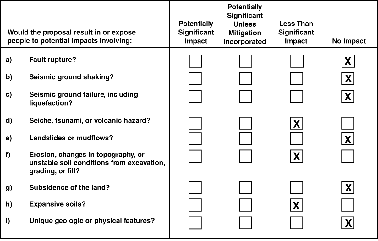
a) Fault Rupture
In major earthquakes, fault displacement can cause rupture along the surface trace of the fault, leading to severe damage to any structures or other improvements located on the fault trace. Surface rupture generally occurs along an active fault trace, but displacement along faults with much older displacement history also occurs. No aspect of the project would alter seismic hazards at the respective plant sites.
Morro Bay
The site is not located in the immediate vicinity of an earthquake fault. (The nearest fault is 4 miles from the site.) Therefore, no impact related to fault rupture would occur (Jennings, 1994).
Moss Landing
The site is not located in the immediate vicinity of an earthquake fault. (The nearest fault is 11 miles from the site.) Therefore, no impact related to fault rupture would occur (Jennings, 1994).
Oakland
The site is not located in the immediate vicinity of an earthquake fault. (The nearest fault is 4 miles from the site.) Therefore, no impact related to fault rupture would occur (Jennings, 1994).
Conclusion
Because none of the three plants to be divested would be located very near a fault, no impact related to fault rupture would occur.
b) Seismic Ground Shaking
Morro Bay
For an earthquake similar in magnitude to the Loma Prieta quake but occurring on the San Andreas or Rinconada Faults near Morro Bay, the site would lie outside the area of strongest ground shaking. The maximum credible rock acceleration that could affect the Morro Bay site is estimated to be between 0.3 and 0.4g for a Richter magnitude 7.0 or higher quake (7.5 on the Rinconada Fault) (Greensfelder, 1974).
Moss Landing
For an earthquake similar in magnitude to the Loma Prieta quake but occurring on the San Andreas, Rinconada, Sargent, Hayward or Calaveras Faults near Moss Landing, the site would lie just outside the area of strongest ground shaking. The maximum credible rock acceleration that could affect the Moss Landing site is estimated to be between 0.4 and 0.5g for a Richter magnitude 7.0 or higher quake (7.5 on the Rinconada or Calaveras Faults) (Greensfelder, 1974).
Oakland
For an earthquake greater in magnitude to the Loma Prieta quake but occurring either on the San Andreas Fault near San Francisco (maximum expected magnitude 8.25), or the Calaveras or Hayward Faults near Oakland (maximum expected magnitude 7.5), the Oakland site would lie just inside the area of strongest ground shaking. The maximum credible rock acceleration that could affect the Oakland site is estimated to be between 0.4 and 0.62g for a Richter magnitude 7.5 or higher quake (8.25 on the San Andreas Fault) (Greensfelder, 1974).
Conclusion
Because the project involves a change of ownership of the plants, and that significant new construction at the plants is not reasonably foreseeable as a consequence of the project, it would not affect the nature of ground shaking at any of the sites. Therefore, no impact related to seismic ground shaking would occur.
c) Seismic Ground Failure
Earthquakes or aftershocks may cause secondary ground failures. Ground failures are caused by soil losing its structural integrity. Examples of seismically-induced ground failures are liquefaction, lateral spreading, ground lurching, and subsidence. Liquefaction (the rapid transformation of soil to a fluid-like state) affects loose saturated sands. Earthquake ground shaking induces a rapid rise in excess pore pressure and the soil loses its bearing strength, and it may spread laterally, undergo settlement and form fissures and sand boils (upwellings of sand at the surface). Lateral spreading is the horizontal movement of loose, unconfined sedimentary and fill deposits during seismic activity. Ground-lurching is the horizontal movement of soil, sediments, or fill located on relatively steep embankments or scarps as a result of seismic activity, forming irregular ground surface cracks. The potential for lateral spreading or lurching is highest in areas underlain by soft, saturated materials, especially where bordered by steep banks or adjacent hard ground. Subsidence is vertical downward movement of the ground surface.
The potential for ground failure is described for each site below. However, the effects at each site produced by amplification of ground shaking in soft Bay muds and overlying fill and potential ground failure are reduced by construction measures which address both the geologic materials and structure design considerations.
Morro Bay
The Morro Bay site is located in an area of moderate seismic activity, in relatively close proximity to several major active faults and with an underlying geologic base that may be prone to amplify ground shaking. Ground shaking in the area is an unavoidable hazard, since it is impossible to prevent the area from being affected by major earthquakes. Because of the nature of the sand and gravel fill and underlying Pleistocene sediments, ground failure of one sort or another is expected in the area during or following a seismic event. The ground failure may be liquefaction of sand beds or lenses, lateral spreading or lurching of sediments, or subsidence of fill and underlying sediments. On-site facilities could be damaged or destroyed as a result of seismic shaking.
Moss Landing
The Moss Landing site is located in an area of high seismic activity, in relatively close proximity to several major active faults and with an underlying geologic base that may be prone to amplify ground shaking. Ground shaking in the area is an unavoidable hazard, since it is impossible to prevent the area from being affected by major earthquakes. Because of the nature of the interbedded sands and clays, ground failure is most likely to occur as liquefaction of sand beds or lenses. Lateral spreading or lurching of sediments is not anticipated, however, subsidence of fill may occur. On-site facilities could be damaged or destroyed as a result of seismic shaking.
Oakland
The Oakland site is located in an area of high seismic activity, in relatively close proximity to several major active faults and with an underlying geologic base that is prone to amplify ground shaking. Ground shaking in the area is an unavoidable hazard, since it is impossible to prevent the area from being affected by major earthquakes. Because of the nature of the artificial fill and underlying Bay muds and alluvial soils, ground failure of one sort or another is expected in the area during or following a seismic event. The ground failure may be liquefaction of sand beds or lenses, lateral spreading or lurching of Bay muds, or subsidence of fill and underlying Bay muds. On-site facilities could be damaged or destroyed as a result of seismic shaking.
Conclusion
If new owners wish to modify the plants, developed entitlement and associated environmental review would be required. Appropriate geotechnical design and adherence to the seismic requirements of the Uniform Building Code would be required and would reduce impacts from ground failure to acceptable levels of risk for any construction that may result from the project. However, substantial new construction is not a foreseeable consequence of the project. The project would not alter the hazards of ground failure resulting from seismic events. Therefore, no impact of the project is anticipated.
d) Seiche, Tsunami, and Volcanic Hazards
Earthquakes can cause tsunami ("tidal waves"), seiches (oscillating waves in enclosed water bodies), and landslide splash waves in enclosed water bodies such as lakes, reservoirs, and the San Francisco Bay. Earthquakes can also result in dam failures at reservoirs. Each of the plants are located near the coast and construction of new facilities on the sites resulting from the project could therefore be vulnerable to damage from tsunami. Because of the remote likelihood of occurrence, this impact would be less than significant. The sites are not located in the vicinity of a volcano. Therefore, no impact related to volcanic hazards would occur.
Conclusion
Less than significant tsunami hazard could occur to any new construction generated by the project at the Morro Bay Power Plant, but new construction is not foreseeable, and the project would not alter conditions that create tsunami and seiche hazards. No tsunami-related impacts would occur at Moss Landing or Oakland, nor would impacts related to seiche, or volcanic hazard occur.
e) Landslides and Mudflows
Morro Bay
The power plant site is relatively flat and would not be subject to landslides or mudflows. The tank farm site is located in a hilly area which could be subject to landslide hazard. However, no new construction at the tank farm site is deemed reasonably foreseeable, therefore no changes in conditions or impacts related to the project would occur.
Moss Landing
With the exception of the northeastern corner of the tank farm site, the site is characterized by gentle slopes of less than 10 percent. There is no historical evidence of landslide activity in the vicinity of the site, including the tank farm site. Therefore, no hazard or impact related to landslides or mudflows would occur.
Oakland
Since the site is essentially flat, no hazard or impact related to landslides or mudflows would occur.
Conclusion
Because the power plant sites to be divested are either flat or gently sloping, no hazards or impacts related to landslides or mudflows would occur as a result of the project.
f) Erosion, Changes in Topography, and Unstable Soil Conditions
Local Issues
Unstable soil conditions include settlement and low strength. Settlement can occur either uniformly or differentially. Uniform settlement of a building can cause poor drainage and potential failure of underground utility connections. Differential settlement can damage a foundation and cause mechanical and structural problems within a structure. The magnitude of settlement of a fill will depend on the quality of the fill material and the manner in which it is placed, the thickness of the fill, and the type of subsurface soil. Differential settlement, such as could occur under facilities built on artificial fill, could cause cracking of foundations and roadbeds. The magnitude of the settlements at the three power plant sites cannot be estimated without subsurface exploration and laboratory testing. For any new construction on any of the sites, a site-specific geotechnical investigation would be required as appropriate to determine the presence and characteristics of potentially compressible soils on the site, the engineering properties of the foundation materials at the site, the depth and thickness of soil layers, and the depth(s) of the water table(s). Assuming that standard engineering, design and construction practices were adhered to (see discussion regarding checklist item 4.3), impacts resulting from unstable soil conditions would be less than significant. In any event, however, no substantial plant modification or construction is anticipated as a result of divestiture.
All three power plant sites are almost flat. The Morro Bay tank farm site is located in an area with moderate to high erosion potential. However, no reasonably foreseeable changes to the tank farm operation would result from the project and no changes in topography or erosion would be expected. Any construction resulting from the project would not involve changes in topography and would have little risk of erosion. On-site erosion and sedimentation from minor construction projects and soil remediation activities that may be part of the ownership transition, however, could result in contact of stockpiled soil with runoff and wind. As described in Section 4.9(d), Hazards, soil contamination that may be exposed due to on-site erosion or sedimentation during minor construction or during remediation activities can be reduced under the oversight of regulatory authorities, such as the California Department of Toxic Substances Control or local county health departments. Worker safety related to remediation activities is promoted by federal and state OSHA regulations.
Permits may need to be obtained prior to any remediation work, and a remediation plan is usually prepared before such work begins. Remediation plans, and sometimes permits themselves, require that specified precautions be taken during remediation in order to protect human health and the environment. Examples of such procedural and operational controls that typically are implemented during remediation activities include covering soil stockpiles to prevent erosion and reduce infiltration, installation of a leachate control system to capture any leachate generated, construction of a containment cell to prevent run-off, installing treatment systems for treating ground water, surface water, or air containing hazardous substances, collecting and analyzing test samples, watering disturbed areas to reduce dust generation, and requiring workers to wear proper personal protective equipment to prevent worker contact with contaminated soil or ground water. Many of these controls are contained in permit requirements that are issued by regulatory agencies overseeing remediation activities.
Whatever entities own these plants, PG&E or any future purchaser, they would be subject to the same environmental and worker safety laws, rules and regulations. The plants, under whatever ownership, would be expected to conform to all pertinent environmental and safety requirements.
Conclusion
The project could result in erosion and unstable soil conditions due to minor construction activities and required soil remediation. Required remediation necessary to protect human health and the environment would be conducted in accordance with applicable laws and regulations under the oversight of local agencies. Further, under the terms and conditions of the purchase and sale agreement, PG&E has agreed to be responsible for any legally required remediation of existing contaminated soil and ground water at divested plants and therefore will be responsible for remediation activities that are a part of the ownership transition. Therefore, the impact would be less than significant because of current agreements and the regulatory environment.
g) Subsidence of the Land
Subsidence is caused by the removal of ground water and resultant aquifer draw down. The project would not reasonably result in either a dramatic increase in water use at any of the sites, or the installation of ground water wells.
Conclusion
Because the project would not affect the potential for ground water subsidence, no impact would occur.
h) Expansive Soils
Expansivity, or shrink-swell, is the cyclic change in volume that occurs in fine-grained sediments because of expansion and contraction of clay caused by wetting and drying. The potential for shrink-swell is greatest in areas underlain by fine-grained basin deposits. This problem can usually be overcome with proper foundation engineering (Helley & LaJoie, 1979).
If new owners wish to modify the plants, developed entitlements and associated environmental review would be required. Assuming that appropriate engineering, design and construction practices are adhered to, as would be expected, impacts resulting from expansive soil conditions would be less than significant.
Conclusion
No substantial construction or earthmoving activities are reasonably foreseen as a result of the project. Should any minimal construction be undertaken as part of the project, it would be conducted with the use of standard construction practices. Thus the impact of expansive soils would be less than significant.
i) Unique Geologic or Physical Features
Morro Bay
Morro Rock is a unique geologic feature located approximately 2,000 feet from the site boundary. Morro Rock would not be affected by any activity on the power plant site. There are no other unique geologic or physical features located on or near the site.
Moss Landing
The Moss Landing site is characterized by gentle slopes with no unusual rock outcroppings or other noteworthy physical features. There are no unique geologic or physical features located on the site.
Oakland
The site is completely developed and located in an urban area. There are no unique geologic or physical features located on the site.
Conclusion
Because the project would not affect any unique geologic or physical features, no impact related to such features would occur.