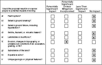
- -e) The proposed project is not anticipated to result in or expose people to potential impacts involving fault rupture, seismic ground shaking, seismic ground failure, seiche, tsunami, volcanic hazard, landslides or mudslides.
III. GEOLOGIC PROBLEMS
The Geysers and Fulton sites are located within a seismically active area of Northern California. The project sites are within the San Andreas Fault System (SAFS), a complex regional tectonic zone characterized by several large active right-lateral, strike-slip faults and numerous smaller active and potentially active faults. This region is within Seismic Zone 4, the highest seismic hazard zone designated by the Uniform Building Code. The PG&E substation facilities and power lines would be designed in conformance with CPUC General Order 95 to withstand earthquakes, and substantial seismic damage to the Geysers and Fulton substations or power lines from earthquakes is not anticipated.
No known active faults are located at either project site. The sites are not within an Alquist-Priolo Earthquake Fault Zone, and are not expected to be exposed to fault rupture. The project sites have the potential to be impacted by earthquakes and earthquake related hazards from the effects of ground-shaking. The level of seismic shaking at a site is a function of size and energy release at the source (magnitude), the distance between the site and the source, and the type of earth materials that underlie the site. The intensity of ground shaking decreases with distance from the source. In general, poorly consolidated sediments (soft soil) tend to amplify shaking relative to well-consolidated sediments (stiff soil) or bedrock.
The closest active fault zone to the Fulton Substation site is the Rodgers Creek Fault Zone, located approximately 1.3 miles northeast of the site. The fault is capable of generating a magnitude 7 earthquake (WGCEP) 1990, Toppozada et al. 1994). The likelihood of such an event occurring in the period between 1990 and 2020 is 22 percent. An earthquake of this magnitude on the Rodgers Creek Fault Zone would generate very strong seismic shaking of Modified Mercalli Intensity (MMI) VIII at the Fulton site.
Other fault zones could produce moderate to strong ground shaking that could potentially affect the project area. These include the San Andreas and the Maacama Fault Zones. The Maacama Fault Zone is the closest major fault to the Eagle Rock Substation. Located approximately eight miles to the west, the Maacama Fault Zone could generate a magnitude 7 earthquake. The probability of this event has not yet been calculated. The Big Valley and Collayomi Faults are smaller active faults in the Clear Lake Highlands. The Geysers site experiences microseismicity (magnitudes of less than 1 to 3) on a daily basis related to the natural movement of molten rock below the surface as well as effects of geothermal energy production activities.
Estimates of the peak ground acceleration in an earthquake have been made for the project area based on probabilistic models that account for multiple seismic sources. Under these models, consideration of the probability of expected seismic events is incorporated into the determination of the level of ground shaking at a particular location. The expected peak horizontal acceleration generated by any of the seismic sources potentially affecting the area, including the project site, is estimated by the California Division of Mines and Geology at greater than 0.7g (g = gravitational acceleration). The expected peak acceleration at the Geysers site would be 0.5 to 0.6g.
The facilities at the Geysers site would experience moderate ground shaking from a seismic event within the Rodgers Creek Fault Zone; however, the facility is not expected to sustain significant damage. PG&E power poles and lines are not anticipated to be damaged from ground shaking. Although local surface failures can cause collapse of poles, evidence of unstable soils or slopes were not identified at the proposed pole locations.
The Fulton site is underlain by young alluvial sediment. These sediments may contain relatively young, shallow, saturated granular sediments that may be susceptible to liquefaction or seismically induced compression and settlement. The Fulton site is located in an area identified as having a low to moderate potential for liquefaction (Toppozada et al. 1994).
The Geysers site is underlain with bedrock mantled by cohesive soil, thus the potential for liquefaction is low. This general site area may be affected by seismically-induced landslides, particularly if strong seismic shaking occurs during the rainy season when slopes are saturated. No evidence of active or inactive landslides was found at the proposed pole locations by PG&E’s geologist. Although the slopes may be subject to slope creep in the colluvial soils, the foundations for the poles would be set in bedrock, below the zone of active creep. Minor damage to the proposed maintenance road related to creep, minor landsliding, or erosion could occur. However, it is expected that such damage could be repaired by minor grading and would not be significant.
The proposed project at the Geysers and Fulton sites would comply with the seismic design requirements of the Institute of Electrical and Electronic Engineers Standard 693. The foundations for equipment would be designed by a licensed engineer in conformance with the requirements of the Uniform Building Code. No impacts to power lines and substation facilities are anticipated with the implementation of these standards.
The topography of the Geysers site is rugged. While the surrounding area is moderate to relatively steep, Geysers Unit 11 and the Eagle Road Substation are constructed on engineered flat pads. The first new pole near Unit 11 is located on a flat site where the road is widened. Erosion hazards for the Stonyford gravelly loam and Los Gatos loam soils mapped (USDA, 1971) along the proposed 115 kV power line alignment are high to very high.
Minor grading would be required at the Fulton site. PG&E will obtain a grading permit from the Sonoma County Permit and Resource Management Department prior to construction. Six new tubular steel poles would be installed at the Fulton site. The installation of three of these poles north of the existing substation security fence, but within the utility-owned property, would require leveling existing dirt piles that are 3 to 4 feet high to provide access for the foundation auger rig. The topography is flat at the pole locations and access would only require blading of the dirt piles and an adjacent field. No grading would be required for the other three poles which would be installed inside the substation fence.
Five new pole locations would be installed for the new 115 kV power line at the Geysers site. Accessing two of these pole locations with the foundation auger rig would require construction of two access spur roads that would total approximately 400 feet in length and 15 feet in width. Approximately 500 cubic yards of earth would be excavated. The grading would create a minor change in the topography at these sites. Because of the steep slope and generally higher erosion rates in the Geysers, the potential exists for significant erosion in graded areas including the two proposed access roads after the vegetation cover is removed. The impact is potentially significant.
Mitigation Measures:
M.IIIf.1. Engineered erosion control measures and drainage features to control runoff shall be employed consistent with Sonoma County grading ordinance requirements. The amount of vegetation cleared shall be kept to a minimum to accommodate the road. All cleared areas shall be immediately seeded.
M.IIIf.2. Consistent with Sonoma County grading requirements, the road shall be sloped as to promote natural sheet flow of water downhill and avoid concentrations in the roadway. Wide water bars shall be installed at appropriate intervals along the road. A culvert with rip-rap material at the outlet to dissipate energy shall be installed where the road crosses an existing swale. A water bar on the existing fire road immediately above the proposed access road shall be redirected so that runoff from the fire road is distributed along and down the slope into the swale.
M.IIIf.3. No excavated soils shall be sidecast unless they are graded to blend into the adjacent slope, resoiled and revegetated. Under no circumstances shall spoil be sidecast into or in close proximity to streams, gullies, drainage ditches or wetlands.
Significance After Mitigation: Less than Significant.
TOP
| Forward to Next Section (Water) |
Back to Previous Section (Population and Housing) |
Back to Nothern Geysers Area Reinforcement Project Main Page | CPUC Environmental Page | CPUC Home Page |