Introduction and Background
Welcome to the California Public Utilities Commission (CPUC) web page for the environmental review of Southern California Edison’s (SCE) proposed Control-Silver Peak Project (the “Proposed Project”). The CPUC is the lead agency under the California Environmental Quality Act (CEQA) for the Proposed Project, and is therefore responsible for evaluating the Proposed Project’s potential environmental impacts.
In 2006, SCE identified that the clearances along some of its circuits were not compliant with the clearances required by CPUC General Order (GO)95 (Rules For Overhead Electric Line Construction) due to the installation of additional infrastructure under SCE lines over time. This information was communicated to both the CPUC and the California Independent System Operator (CAISO) and prompted SCE to establish its Transmission Line Rating and Remediation (TLRR) program. Pursuant to the TLRR program, SCE identified discrepancies along its Control-Silver Peak 'A' and 'C' 55 kilovolt (kV) subtransmission lines, which run through the White Mountains in eastern California. The work proposed by SCE to remediate the discrepancies on these circuits consititutes the scope of the Proposed Project.
SCE formally submitted a Permit To Construct (PTC) application for the Proposed Project on August 13, 2021 (A.21-08-009), as specified in CPUC G.O. 131-D. The PTC application, Preliminary Environmental Assessment (PEA), and related project documents are available under the “Project Links and Documents” heading below. After review, CPUC has deemed SCE's application, including its PEA complete. The CPUC has initiated the CEQA review process by distributing a Notice of Preparation (NOP) and holding a scoping meeting, and is now in the process of preparing the Draft Environmental Impace Report (DEIR).
Because portions of the Proposed Project alignment are located within the Inyo National Forest managed by the U.S. Department of Agriculture, Forest Service (USFS) and other lands managed by the U.S. Department of the Interior, Bureau of Land Management (BLM), the Proposed Project will also be subject to review under the National Environmental Protection Act (NEPA). The NEPA process is being managed by the BLM. For information, please refer to the project homepage on the BLM's E-Planning website: https://eplanning.blm.gov/eplanning-ui/project/2024995/510.
Additional information on the Proposed Project and the CPUC’s environmental review process are provided below.
PEA Deficiency Letters, CPUC Data Request, and Applicant Responses
CPUC Request
|
SCE Response
|
Response Attachments
|
| Deficiency Letter #1 (Septermber 15, 2021) (716 KB) |
Response #1 to Deficiency Letter #1 - Batch #1 (November 16, 2021) (573 KB)
Response #2 to Deficiency Letter #1 - Batch #2 (December 17, 2021) (1,162 KB)
Response #3 to Deficiency Letter #1 - Batch #3 (March 16, 2022) (350 KB) |
None |
| Deficiency Letter #2 (July 15, 2022) (520 KB) |
Response #1 to Deficiency Letter #2 - Short Term Responses (September 16, 2022) (305 KB)
Response #2 to Deficiency Letter #2 - Long Term Responses (October 19, 2022) (110 KB)
Response #3 to Deficiency Letter #2 - Additional Wildfire-Related Responses (December 2, 2022) (215 KB) |
Construction Fire Management Plan (1,070 KB)
Invasive Plant Management Plan (790 KB)
Habitat Restoration Plan (2.83 MB)
Tree Assessment Summary (58.9 MB)
Revised Figure 5.20-5a, Fire Occurrence (2.57 MB)
Revised Historic-ERA Built Environment Survey Report (HBER) (March 2023 version) - confidential |
Data Request No. 1 (January 25, 2024) |
Response to Questions #001 through #006 Data Request No.1 (February 8, 2024) (116 KB)
|
Appendix L: Equipment List (February 8, 2024) |
| Data Request No. 2 (August 30, 2024) |
Response to Questions #001 through #017, Data Request No.2 (January 6, 2025) (4,930 KB) |
Historic Golden Eagle Nests Map (January 31, 2025) (2,091 KB)
Habitat Restoration Plan (October 2023) (1,532 KB)
Sensitive Species and Habitat Report - Botanical Addendum (November 2023) (143,203 KB)
Draft Bi-State Sage-Grouse on the Inyo National Forest Management Plan (April 2023) (338 KB) |
| Data Request No.3 (January 27, 2025) (302 KB) |
Response to Question #001 Data Request No.3 (February 18, 2025) (606 KB) |
Attachment A - TLRR Control-Silver Peak 55kV Project Highway 168 Alternative Analysis (February 18, 2025) (3,576 KB) |
| Data Request No.4 (February 28, 2025) (184 KB) |
|
|
Project Objectives
Applicant's Stated Objectives
The objectives of the Proposed Project, as stated by the Applicant in its PEA, are as follows:
- Ensure compliance with standards contained in CPUC GO 95 and North American Electric Reliability Corporation (NERC) Facility Ratings while also maintaining reliable service to customers served by the subject lines, substations, and metering stations.
- Remediate clearance discrepancies along two existing 55 kV subtransmission lines in order to comply with the standards contained in GO 95 Rule 37, Minimum Clearances of Wires above Railroads, Thoroughfares, Buildings, Etc., Table 1; Rule 38, Minimum Clearances of Wires from Other Wires, Table 2; and Rule 39, Minimum Clearance of Wires from Signs.
The Applicant also states that "remediating the identified discrepancies will bring the lines into operational compliance with SCE’s published facility rating, which requires a review of actual field conditions as recommended by NERC. Remediating the identified discrepancies will also comply with applicable Western Electricity Coordinating Council (WECC) reliability planning criteria."
Proposed Project
Project Description
The Proposed Project would consist of a variety of improvements to existing infrastructure, which would serve to correct identified discrepancies with the GO 95 standards. This would include rebuilding, replacement, and/or modification of existing subtransmission poles and conductors along portions of the Control-Silver Peak ‘A’ and ‘C’ 55 kV circuits. Additionally, SCE proposes to install overhead groundwire (OHGW) and optical groundwire (OPGW) along portions of the subtransmission line alignments, and transfer existing distribution circuitry underbuilt on the subtransmission structures to replacement poles. SCE would install additional telecommunications cables and equipment within and adjacent to existing substations, and would make other improvements within area substations that interconnect with the Control-Silver Peak ‘A’ and ‘C’ 55 kV subtransmission lines.
SCE has subdivided the Proposed Project into five segments based on the geographic extent and type of work proposed.
The segments and the specific work associated with each one are described below.
- Segment 1: Segment 1 of the Proposed Project is located west of the City of Bishop. Segment 1 is 3.4 miles in length. There are two single-circuit pole lines in Segment 1. In Segment 1, the existing overhead groundwire (OHGW) that is installed on existing poles along one of the two pole lines found in Segment 1 would be removed and optical groundwire (OPGW) would be installed on those existing poles.
- Segment 2: Segment 2 of the Proposed Project is located northwest of the City of Bishop. Two existing single-circuit pole lines are located in Segment 2. The existing poles and conductor would be removed, and new poles and conductor would be installed along the 1.4-mile length of Segment 2. OPGW would be installed on new poles along one of the pole lines, and OHGW would be installed on new poles along the other pole line.
- Segment 3: Segment 3 runs for approximately 37 miles from northwest of the City of Bishop to the California-Nevada border. Two existing single-circuit pole lines are located in Segment 3; the Proposed Project would result in removal of one of the pole lines and conversion of the remaining pole line from a single-circuit configuration to a double-circuit configuration. The existing poles and conductor would be removed, and new double-circuit poles and conductor would be installed along the length of Segment 3. OPGW would be installed on new poles.
- Segment 4: Segment 4 is located in the Chalfant Valley between the City of Bishop and the community of Hammil. InSegment 4, two existing poles would be removed and two replacement poles would be installed. Theexisting conductor attached to the poles would be transferred to the replacement poles. Insulators andother hardware on adjoining poles may be replaced or modified to accommodate the taller replacementpoles.
- Segment 5: Segment 5 is located in the Deep Springs Valley. In Segment 5, nine existing poles would be removed and nine replacement poles would be installed. The existing conductor attached to the poles would be transferred to the replacement poles. Insulators and other hardware on adjoining poles may be replaced or modified to accommodate the taller replacement poles.
No new substations would be constructed under the Proposed Project. However, modifications at and adjacent to existing substations (i.e., Control, White Mountain, Zack, and Deep Spring substation) and the Fish Lake Metering Station would be necessary to accommodate the installation of new conductor and systems protection equipment. Specifically, the Proposed Project would include the following work at substations:
- Disconnect existing conductor from existing positions at the White Mountain Substation and connect new conductor to existing positions.
- Install new OPGW and OHGW and make minor modifications to the exisitng terminal racks at White Mountain Substation to accomodate the new OPGW and OHGW.
- Install telecommunication equipment on existing rack structures, install cable in new or existing underground cable raceways, and install new or replacement telecommunications infrastructure within existing cabinets, control buildings, or Mechanical and Electrical Equipment Rooms within the Control Substation and at the Fish Lake Valley Metering Station.
- Update relay settings at Control, Deep Springs, White Mountain, and Zack Substations.
- Install a capacitor bank and circuit breaker at Fish Lake Valley Metering Station.
Project Location
The Proposed Project would be located within unincorporated Inyo County and unincorporated Mono County; an overview map of the Proposed Project alignment is provided here. The Project vicinity is within eastern California and is part of a region that extends from the eastern edge of the Sierra Nevada to the Colorado Plateau. This region is characterized by abrupt changes in topography, with steep, relatively narrow mountain chains, generally oriented on a north-south axis, that are separated by flat, arid alluvial valleys. Topography in the Proposed Project area extends from the Owens Valley on the west to Fish Lake Valley on the east and is dominated by the intervening White Mountains. Elevations in the Proposed Project area range from approximately 4,200 feet in the valley bottoms to over 10,000 feet above mean sea level at its high point.
Land uses in the Proposed Project area are a mixture of rural residential development, residential and commercial land uses in the vicinity of the City of Bishop, irrigated agriculture and associated residences in Fish Lake Valley and an institutional use (Deep Springs College). Portions of the Proposed Project alignment are located within the Inyo National Forest and on BLM desert lands.
Environmental Review
Overview
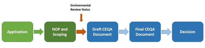
The CPUC has deemed A.21-08-009 complete; thus, the Proposed Project will now be subject to environmental review under CEQA. The CPUC's CEQA environmental review process is anticipated to be performed generally in parallel with the federal NEPA review process. The CPUC has distributed an NOP (available above under "Project Links and Documents") and held a CEQA scoping meeting for the Proposed Project, as discussed further below. The CPUC is now in the process of preparing the EIR.
Scoping
The issuance of the NOP marked the beginning of the scoping period for the Proposed Project, which initially lastd until September 18, and was later extended to October 27, 2023. During the scoping period, the CPUC accepted written comments on the scope and content of environmental analysis to be included in the EIR at the contact addresses shown below. The CPUC held a virtual scoping meeting on Wednesday, August 30th at 5pm. via Zoom
The scoping meeting featured a presentation by CPUC and consultant staff, describing the Proposed Project and CEQA process and was followed by an opportunity for meeting attendees to ask questions and submit oral comments. Written comments were accepted for the duration of the scoping period and five comments letters were received during this time. A copy of the scoping summary report, which includes the written comment letters received (see Attachment A to the report) can be found here.
Draft Environmental Impact Report Preparation
The CPUC is now preparing the DEIR for the Proposed Project. During the DEIR preparation, the CPUC will consider the comments received during the scoping period, as documented in the scoping summary report. When the DEIR is ready for circulation, the CPUC will issue a Notice of Availability (NOA) of a DEIR, which will provide information on whree and how to review the DEIR, attend a public meeting on the DEIR, and submit comments during the DEIR review period. The NOA will be distributed to interested parties and filed with the State Clearinghouse.
For Additional Information
The CPUC's Environmental Review Team is managing the environmental evaluation of the Proposed Project. To request additional information or to be added to the mailing list, please contact us by email, fax, or phone at:
|