III. GEOLOGIC PROBLEMS
The project site is located in the Santa Clara Valley, approximately 6 miles south of the southern margin of the San Francisco Bay. Geologically, the Santa Clara Valley is characterized by a deep structural depression filled with sediment derived from the erosion of adjacent uplands and marine deposition. The substation site is essentially flat and the overall project area for the power line ranges in elevation from 60 and 70 feet above mean sea level.
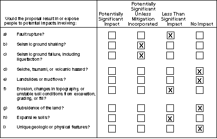
The Alquist-Priolo Earthquake Fault Zoning Act requires the delineation of zones along sufficiently active and well-defined faults. The purpose of the Act is to restrict construction of structures intended for human occupancy along traces of active faults, thus reducing the hazards associated with fault rupture. There is no evidence of the presence of an active fault at the site. The project site is not located within an Alquist-Priolo Earthquake Fault Zone established for the active faults in this region. The presence of a concealed fault, e.g., a low angle thrust fault, buried at great depth under the thick sediments of the area is a potential hazard that cannot be determined with available information. (An undiscovered concealed fault of this type was the source of the 1994 Northridge Earthquake in the Los Angeles area that damaged substation and transmission facilities.) While the possibility for a concealed fault cannot be entirely discounted, given the seismic history of the Santa Clara Valley, the potential hazard posed by a concealed undetected fault is considered speculative and a less than significant hazard.
The main potential project-related hazard to structures and people in the project area would be from seismic activity. The project site is located in the Coast Range Geomorphic Province, which is an area of relatively high seismic activity. Several major northwest-trending fault zones are anticipated to generate major earthquakes that could induce significant ground shaking at the site, including the San Andreas Fault Zone (the dominant fault zone in California), and a number of smaller fault zones are located within 40 miles of the project site. In addition to the San Andreas and Hayward faults, other potentially active faults are listed in Table III-1. A major earthquake on any of the faults listed in Table III-1 could produce strong groundshaking at the site, affecting the proposed facilities (see discussion under [a], above). Shaking amplification is rated as "very high"(7 on a scale of 1 to 8, with 8 rating the highest amplification) and the modified Mercalli intensity is rated as high as IX-Heavy (9 on a scale of 1 to 10, with 10 rating as extreme) for a major 7.3 earthquake on the entire Hayward Fault (ABAG, 1995). In an earthquake of that magnitude, damage to structures, roads and infrastructure would be heavy throughout the project area.
Because the substation site would be fenced and locked, direct public access would be prevented. Therefore, unless workers were present onsite, no injuries to people on the site would occur during earthquakes. The earthquake hazards are potentially significant only for the substation facilities themselves. To the extent that these would be rendered inoperable by an earthquake, the result could be a loss of power in the service area. However, a major earthquake that could affect the site is also likely to affect a wide area in the South Bay. By providing better linkage of power transmission in the area, the project would likely result in a net improvement to system reliability during and following a major earthquake.
PG&E, in conjunction with other utilities and equipment vendors throughout the country, have revised IEEE 693, "Recommended Practices for Seismic Design of Substations," to address equipment and voltage-specific seismic qualification requirements. These requirements are generally more stringent than the Uniform Building Code (PG&E, 1998). Equipment for the FMC Substation will be procured using the seismic qualification requirements of IEEE 693. Following these requirements, it is anticipated that no structural damage would occur if the substation were subjected to peak ground accelerations levels approaching 1 g (gravitational acceleration). Compliance with the IEEE 693 and, where applicable, the Uniform Building Code, would reduce groundshaking effects to levels of acceptable risk and result in a less than significant impact from seismic hazard.
Groundshaking, and in some project areas liquefaction, could result in damage to power lines. The conductor wires are strung with sufficient length and catenary (sag) to accommodate vibratory motions and tensions set up by ground motions in earthquakes or high winds. In other words, it is considered a remote hazard that the power lines would "snap" because of earthquake groundshaking. On the other hand, earthquake induced vibratory motions in power lines have resulted in "wrapping" of the lines in which the separate conductor lines come into physical contact with each other. For example, wrapping was recorded as an effect of the 1989 Loma Prieta Earthquake. Wrapping is a potentially hazardous situation because the "hot wires" come into contact, although it would not likely cause the lines to break and fall. PG&E’s design and spacing requirements would be expected to be in conformance with requirements and industry standards for conductor separation.
The primary potential cause of failure of power lines would result from the failure of one or more of the poles supporting the conductors. Tubular steel poles are structurally extremely strong and able to resist earthquake induced vibratory motions (or high winds) without failure, as evidenced by their performance in the Loma Prieta Earthquake, the 1994 Northridge Earthquake, and other earthquakes. Bending or breaking of the poles would be a remote hazard. The failure of poles is more likely potentially related to a failure of the foundation support as a result of liquefaction and/or lateral spreading (or landsliding, which is not a hazard present in the project area). See the discussion under item III.c, below.
Earthquakes or aftershocks may cause secondary ground failures. Ground failures are caused by soil losing its structural integrity. Examples of seismically induced ground failures are liquefaction, lateral spreading, ground lurching, and subsidence. Liquefaction (the rapid transformation of soil to a fluid-like state) affects loose saturated sands. Earthquake ground shaking induces a rapid rise in excess pore pressure and the soil loses its bearing strength, and it may spread laterally, undergo settlement and form fissures and sand boils (upwellings of sand at the surface). Lateral spreading is the horizontal movement of loose, unconfined sedimentary and fills deposits during seismic activity. Ground lurching is the horizontal movement of soil, sediments, or fills located on relatively steep embankments or scarps as a result of seismic activity, forming irregular ground surface cracks. The potential for lateral spreading or lurching is highest in areas underlain by soft, saturated materials, especially where bordered by steep banks or adjacent hard ground. Subsidence is vertical downward movement of the ground surface.
Previous geotechnical studies determined the soil stratigraphy beneath the project site consists of stiff clays and dense sands and gravels (Dames and Moore, 1997). The FMC Substation site is located in an area considered to have a low to moderate liquefaction potential. Analyses show that the probabilities for liquefaction in areas with groundwater elevations similar to those in the project area are 1% to 1.5 % annually and 40 % to 50 % in a 50-year period. Soils in the vicinity of Substation "B" have a high potential for liquefaction (PG&E, 1998). Secondary hazards from seismic activity that could affect the site are lateral spreading and ground settlement (subsidence). The potential for liquefaction causing extensive soil deformation (lateral spreading and subsidence) is less than that of liquefaction resulting in small surface deformations (PG&E, 1998). Lateral spreading or lurching could occur along the banks of the Guadalupe River, threatening the integrity of the proposed transmission poles. The hazard would be greatest for poles in the area nearest to Substation B, where liquefaction and lateral spreading are possible hazards. A loss of foundation support for the poles could cause them to tip or collapse, bringing down the conductors. If the wires were energized at the moment of tipping or collapse, the "hot" wire would pose a potential hazard to people in the area and could ignite fires. While the potential for earthquake induced hazards are unavoidable, conformance with industry standard design requirements for the poles and their foundations would reduce the hazard to an acceptable level of risk. Therefore, the impact, with mitigation, is considered less than significant.
Mitigation
The following mitigation measure would reduce the potential impact of earthquake hazards to an acceptable level of risk, and therefore, to a less-than-significant level.
Mitigation Measure III.c.1. PG&E shall undertake geotechnical studies for the sites of all new power line poles to determine the hazards of liquefaction, lateral spreading, lurching, weak soils subject to settlement, or other forms of failure under design forces for a maximum credible earthquake (MCE) in the area. The report shall summarize findings about the hazards and provide the recommendations of the certified engineering geologist to ensure that the foundations of power line poles will be designed to prevent their failure under MCE ground motions and coseismic hazards. PG&E will implement the recommendations of the engineering geologist as requirements in the design and construction of the poles. A copy of the report shall be filled with the CPUC.
Earthquakes can cause tsunami ("tidal waves"), seiches (oscillating waves in enclosed water bodies), and landslide splash waves in enclosed water bodies such as lakes and reservoirs. The project site is not located near a tsunami run-up area or near an enclosed body of water such as a reservoir or lake. Therefore, this is considered a less than significant impact.
The project site is essentially flat, and is not located in the vicinity of uplands characterized by unstable slopes; therefore, hazards associated with landsliding are not considered a hazard on the project site.
Unstable soil conditions include settlement and failure from low strength. Substation site soils are not of the types characterized by low strength. Settlement can occur either uniformly or differentially. Uniform settlement of a structure can cause poor drainage. Differential settlement can damage foundations and cause mechanical and structural problems within a structure. The magnitude of settlement of a fill or native clay material will depend on their properties, the manner in which the fills are placed, the thickness of the material, the type of underlying subsurface soil, and the load placed on the material. Settlement beneath the proposed transformer bank foundations is expected to occur due to compressibility of native, near-surface "Adobe-clay". Total settlement is expected to range between 1.5 and 2 inches. This could be accommodated within the project design. As standard engineering, design, and construction practices are proposed in conformance with PG&E construction guidelines, impacts resulting from settlement would be minor and the hazard would be less than significant.
The project site would require minimal additional grading of the flat site to construct the proposed substation and would not result in any changes in topography. Construction of the substation foundation and a cement block wall along the eastern perimeter of the site would disturb site soils: temporarily exposed site soils may be subject to erosion by rain splash and overland flow of stormwater for the duration of the construction activities. Site preparation would entail minor regrading, resurfacing, and paving of portions of the site, eliminating any long-term hazard. Because the site is flat and the soils have a high clay content, soil erosion from construction activities would not result in significant hazards of gully formation. Runoff from the site could entrain loose soil and discharge it into storm drains. While the hazard is deemed less than significant, the impacts from erosion and sediment discharges could be eliminated by implementation of standard best construction management practices, as contained in Mitigation Measure IV.c.1, below.
Historic land subsidence due to extraction of groundwater from the underlying Santa Clara Formation has been recorded in this portion of the Santa Clara Valley. However, subsidence was virtually halted by 1971 due groundwater recharge and importation of water. The project would not require the removal of groundwater or any change in groundwater use; therefore, there would be no impact related to ground subsidence.
Expansivity, or shrink-swell, is the cyclic change in volume that occurs in fine-grained sediments because of expansion and contraction of clay caused by wetting and drying. Soils that are expansive (have shrink-swell potential) can damage foundations and other structures. This problem can be overcome with proper foundation engineering (Helley, 1979). Soils on the project site were observed to be clay mixtures with varying degrees of expansive potential. Foundation designs were based on assumptions of groundwater depth. A rise in groundwater following construction at the facility could cause the lean clays (encountered at depths between 5 and 20 feet) to swell. The near-surface Adobe-clay is expected to have high swell potential under no load and marginal swell potential under a load of 2,000 pounds per square foot.
Mitigation
The following mitigation measure would reduce the potential impact of soil expansivity to a less-than-significant level.
Mitigation Measure III.h.1. Foundation engineering design and construction practices should consider the impact of shallow groundwater affecting swell potential of the lean clay. This may entail removal of expansive clays and their replacement with engineered fill, or alternative foundation systems and moisture barriers, which eliminate the shrink-swell effects on the load-bearing foundations. Recommendations of a foundation engineer should be implemented to eliminate or reduce any impacts resulting from expansive soils to a less than significant level. A copy of the recommendations shall be filed with the CPUC.
i) The project area is essentially flat and has no unusual or unique geological features; therefore, there would be no impacts related to unique geologic or physical features.
TOP
| Forward to Next Section (Water) |
Back to Previous Section (Population and Housing) |
Back to FMC Substation Main Page | PG&E Substation Projects Main Page | CPUC Home Page |