IV. WATER
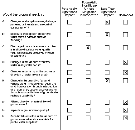
The proposed project would require paving an added portion of the substation site, which would reduce infiltration and slightly increase the amount and rate of runoff. Because the existing site is partially paved and the soils are compacted, a slight increase in runoff at the site could result from the project. Stormwater collected in the Spill Prevention Control and Countermeasure system and pond would contain some of the site runoff and regulate the peak discharge offsite, compared to the current conditions. The impact would be less than significant.
Storm water runoff from other portions of the yard would be directed separately and be discharged to a storm drainage pipe system. This storm drainage pipe system would discharge to the existing 48" city storm pipe located adjacent to Interstate 880. The proposed mitigations would be adequate to reduce operational impacts related to storm water discharge to a less than significant level. Additional mitigation is not required.
The project area is not within a zone of flood hazard as defined by the Federal Emergency Management Agency, Flood Insurance Program. A large earthquake potentially could result in dam failures at reservoirs upstream of the project area. According to dam failure inundation maps (ABAG, 1980) the project site could be impacted by flooding in a dam failure of the Lexington and Vasona Reservoirs, the latter located approximately 8 miles to the southwest. Considering the distance of the two reservoirs from the FMC Substation, topography, and flood control structures currently in place on Los Gatos Creek and Guadalupe River, and the protection created by the Interstate 880 embankment, inundation in this area is likely to be shallow and the quantity of flood water and entrained debris from a dam failure flood would not impair operations at the substation. Therefore, this is considered to have a less than significant impact.
Stormwater discharges during construction might contain high concentrations of pollutants from spills of hazardous substances and total suspended solids. Since this project includes proposed construction activity that would disturb less than five acres (less than 0.2 acre per year) of land, the project is not subject to regulation by the state General Storm Water National Pollution Discharge Elimination System (NPDES) permit. The project would discharge into the city storm drains, that in turn empty into surface waters (Guadalupe River) and San Francisco Bay. Construction of foundations for poles would require borings to a depth of 10-25 feet. If rain occurs during the construction period, some of the removed soil could be discharged in runoff into storm drains, clogging or reducing their capacity. Mitigation included in this Initial Study would result in a less than significant effect on surface waters.
Surface water runoff from the substation site after construction is expected to contain minor concentrations of a variety of pollutants typical of electrical substations (e.g., automobile fluids, suspended solids, metals, and organics), but is not expected to be substantially different than the pollutants currently released from the project site, which is now a parking and storage area. It is not expected that surface water runoff pollutants from long-term operations would occur in concentrations that would be acutely toxic to aquatic life.
Each of the three proposed electrical transformer banks would contain up to 6,500 gallons of inert mineral oil. The transformer would be installed on sealed concrete foundations, and the substation would be surfaced to direct any leaks into an on-site, concrete-lined SPCC pond, to be designed in accordance with PG&E DCS Guideline D-G0052 (January, 1998). The SPCC pond would be designed to contain up to 150% of the oil from the largest piece of equipment. A built-in weir system with a skimmer to collect oil would be constructed to segregate oil from the water, providing stormwater spillover and oil retention. The DCS Guideline requires that the skimmer weir accommodate discharge for a 25-year design storm in combination with no oil. In heavy storm periods, the SPCC pond would be monitored for operational effectiveness of the containment system and proper release of storm discharge. Oil released from a transformer would be directed to the SPCC pond through bermed surface drainage or through underground piping. The SPCC pond would be equipped with a manually operated isolation valve. Pursuant to Environmental Protection Agency requirements, the equipment and spill containment area are inspected on a monthly basis. Operators would not release accumulated rainwater until the SPCC pond is inspected for oil or sheen. This should be adequate to prevent unplanned releases and overflows.
Mitigation
The following mitigation measure would reduce the potential impact of surface water discharge to a less-than-significant level.
Mitigation Measure IV.c.1. If construction is scheduled during the rainy season, PG&E shall employ best construction management practices to prevent discharges of silt and other substances from construction into storm drains. PG&E shall develop and implement a plan to control excavated soils and runoff, specifying practices such as the use of detention basins, straw bales, silt fences or other deterrents, and site clean-up procedures and practices to minimize contact of construction materials with stormwater. PG&E shall file a copy of the plan with the CPUC and shall certify compliance with this measure in progress reports to the CPUC.
No water bodies are present at the substation site or in areas of the proposed power line. The Guadalupe River could be spanned by the power line without impact to the river channel. The project would result in no quantifiable change in impervious surface area and associated storm water runoff. This level of increase would not result in a significant change in the amount of water in any water body.
No watercourse is present on the proposed site. The proposed project would have no effect on the course or direction of surface waters. Installation of the new power line spanning the Guadalupe River is not expected to disturb the riverbed within the limits of the floodplain.
The proposed project is located in the Santa Clara County Groundwater Basin, which is managed by the Santa Clara Valley Water District. Historic groundwater pumping from the underlying Santa Clara Formation has caused land subsidence in portions of the Santa Clara Valley. However, subsidence was virtually halted by 1971 due groundwater recharge and importation of water (Helley and Lajoie, 1979). The project area is located at an elevation between 60 and 70 feet above sea level and is underlain by two groundwater-bearing aquifers. The shallow, unconfined aquifer, referred to as the A-zone, is encountered at depths between 20 to 50 feet below ground surface (bgs). The B-zone is confined to semi-confined and is encountered at depths ranging from 55 to 90 feet bgs. The regional confined aquifer is encountered below the A- and B-zone aquifers at a depth of at least 250 feet bgs. Groundwater flow direction in the A- and B-zones is to the north-northwest (PG&E, 1997). Groundwater beneath the site was measured at 10.5 feet bgs in April 1997 (Dames and Moore, July 1997). It is likely that groundwater depth fluctuates seasonally with rainfall. Substation construction would not require deep cuts that would intercept shallow groundwater or require significant construction de-watering. Construction of some poles for the power line would require bores to a depth of up to 25 feet, potentially penetrating into the upper unconfined aquifer. The small size of the holes is unlikely to have any identifiable effect on the aquifer. Minor temporary dewatering of the bore hole may be required until the cement foundation is poured. The impact would be less than significant.
The project would result in a negligible increase in impervious surface area and would not create other features that would reduce the potential for groundwater recharge. Therefore, there would be no impact related to any change in the quantity of groundwater.
The project would not require removal of substantial amounts of groundwater during construction and none during operation. The project would not include any substantial deep cuts or other features that would intercept or impede the flow of groundwater. The cement foundations to support the power lines poles would have a negligible effect as a barrier to groundwater movement: in most cases they would not intercept the water table at all. Therefore, the project would have no impact on the direction or rate of flow of groundwater.
The compacted fills and impervious surface areas would prevent infiltration of contaminants into the soils. The proposed SPCC pond at the substation would be concrete-lined to prevent infiltration of contaminants from the pond into the subsurface soils. Run off or percolation from the proposed project would not be expected to impact groundwater quality in the area (See also the discussion under checklist item IV.c). After constructing the bore holes for the power line poles, the holes would be immediately filled with cement. This would create a seal that would prevent infiltration of surface contaminants into the groundwater. Therefore, the project would have no impact on groundwater quality.
The proposed project would not use groundwater or impact a local aquifer. Therefore, the project would have no impact on the availability of groundwater for public water supply.
TOP
| Forward to Next Section (Air Quality) |
Back to Previous Section (Geologic Problems) |
Back to FMC Substation Main Page | PG&E Substation Projects Main Page | CPUC Home Page |