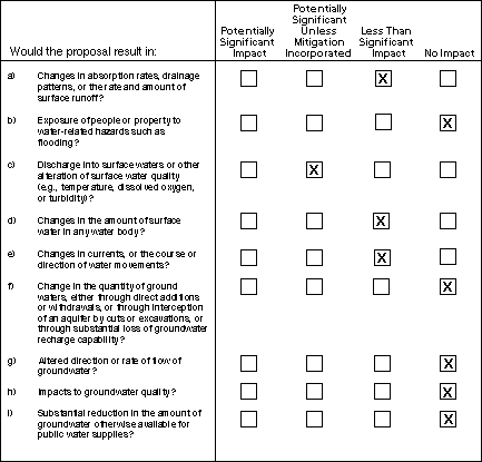
IV. WATER
According to the applicable Flood Insurance Rate Maps (FIRMs) produced by the Federal Emergency Management Agency under the National Flood Insurance Program, the project does not enter into the 100-year floodplain of either Heney or Stevens Creek. The project does lie within Zone B of the FEMA maps. This indicates that the project would lie between the 100-year and 500-year floodplain levels. The Heney Creek Watershed is only 0.64 square miles (409 acres) in size; therefore, it does not generate large flows (270 cfs estimated peak flow compared to 6,000 cfs for Stevens Creek) within the creek channel (PG&E, 1998). Only minimal increases in runoff are anticipated as a result of the project. Therefore, no increase in flood hazards would be expected in downstream areas due to project construction. The above ground project structures do not present any impediment to flood flows, so no exposure of people or property to water-related hazards is expected.
Stormwater discharges during construction could contain pollutants, including suspended sediments from exposed soils and oil from construction equipment. Erosion is expected to be minimal due to the already graded nature of the Monta Vista substation and the project-proposed mitigation listed below. The proposed project would only require limited new grading for installation of the poles and take-off structure, and trenching within roadways for installation of the duct bank. All spoils from excavation would be loaded into dump trucks and removed from the site for disposal at an approved dump location. Trenching near Heney Creek would involve directional drilling with setbacks of 50 feet from both sides of the channel. Construction of the project would have a 100-foot setback from Stevens Creek at the closest point of construction to the creek. Erosion of exposed soils would be controlled by necessary stormwater Best Management Practices (BMPs) as part of a developed erosion control plan (prior to initiation of construction). BMPs for erosion and sediment control would be implemented to avoid impacts to Heney and Stevens Creek. Discharge of sediment or other contaminants into Heney Creek would be minimal under the proposed construction methods. To ensure protection of the water quality of Heney and Stevens Creek, mitigation described at the end of this section has been proposed by the applicant. No other water bodies could be impacted by the proposed project.
The proposed project would cross beneath Heney Creek by directional drilling at an approximate depth of 10 feet below the channel bottom. The project would come within 100 feet of Stevens Creek at its closest point. The minimal increase in surface runoff from the concrete foundations is expected to disperse and infiltrate among the vegetated landscape between the concrete areas and any drainage channels. It is possible that this infiltrated runoff could enter the subsurface flow of the area that adds to Heney Creek during storm events. Subsurface flow is infiltrated surface flow that passes through the vadose or soil zone and may enter the groundwater body or may reemerge to the surface at a lower elevation and enter a surface water body. The movement of subsurface flow into groundwater is dependent upon the existing soil conditions. Groundwater can be defined as water that occurs in saturated zones beneath the soil surface (Brooks et. al, 1991). The distinction between groundwater and subsurface flow can be indistinguishable, but since the normal aquifer level is estimated at 150 feet below the surface in the Monta Vista substation area (PG&E, 1998), the two can be separated. Due to the minimal increase in possible infiltrating surface runoff towards Heney Creek and the relatively flat nature of the site, increases to subsurface flow and subsequent surface flow are expected to be minimal. Therefore, no significant changes in the amount of surface water are anticipated.
The project would not enter into the channel of either Heney or Stevens Creek. Placement of the duct bank below Heney Creek could minimally alter the interaction of surface water and underflow. Water flowing beneath Heney Creek in the underlying channel configuration is considered to be part of the stream system and is identified as underflow (Littleworth and Garner, 1995). Due to the expected depth of placement of the duct bank (10 feet below the creekbed bottom), only minimal or nonexistent changes to the movement of water in the Heney Creek stream system are anticipated.
The quantity of groundwater would not change either through direct additions or withdrawals, or through interception of an aquifer by cuts or excavation, or through substantial loss of groundwater recharge capability. The project is located in the 350 square-mile Santa Clara County Groundwater Basin, which is managed by the Santa Clara Valley Water District. The groundwater basin has experienced significant drawdown historically. The project area is located in a transition zone where soil types from the foothills, consisting mainly of bedrock, meet with the alluvial sands of the valley floor (ESA, 1997). Groundwater is anticipated to lie at 150 feet below the surface in the project area and would not expect to be encountered during construction (PG&E, 1998). Underflow could be encountered during directional drilling (horizontal dry boring) at the Heney Creek site, but it is anticipated that any amount would be minimal and insignificant. If water were encountered during horizontal dry boring, it would be discharged in compliance with the Regional Water Quality Control Board’s Water Quality Control Plan and Santa Clara Valley Water District’s Ordinance No. 83-2. Any minor quantities of water needed during construction for dust control would be supplied by an outside water source.
The groundwater basin is located approximately 150 feet below the surface in the project area. The duct bank would lie between six to ten feet below the impervious road surface. The concrete pads would require excavation to a maximum of 20 feet below the surface. Therefore, the project would not alter the direction or rate of groundwater flow.
The project would not impact groundwater quality. Stormwater Best Management Practices (described below under Applicant Proposed Mitigation) implemented for surface water runoff would keep possible contaminants from groundwater during construction, and placement of the duct bank would not introduce any groundwater contaminants following construction. Construction of the impervious concrete pads for the poles and lattice take-off structure would lessen infiltration and percolation of stormwater into the groundwater aquifer in the immediate area but would not affect groundwater quality.
The proposed project is not anticipated to reduce the amount of groundwater available for public water supply. The proposed project would not use groundwater and would have no measurable effect on recharge or local groundwater use.
Applicant Proposed Mitigation
The following mitigation measures proposed by PG&E would ensure that all impacts to water quality resulting from the project would be less than significant:
· No work would be permitted within 50 feet of Heney Creek and 100 feet of Stevens Creek. Designation of a buffer zone between disturbed soils and nearby creeks would reduce the potential for transport of pollutants to the creeks from the construction site.
·
All spoils would be loaded directly into dump trucks and hauled to approved dumping locations. Collection and disposal of spoils would remove a potential source of sediments for entrainment in stormwater runoff and possible discharge to nearby creeks.·
Implementation of an erosion control plan using Best Management Practices for control of stormwater runoff from the construction site near Heney and Stevens Creek. When correctly implemented and managed, a suitably developed erosion control plan can adequately control erosion and the possible discharge of suspended sediment into waterways.TOP
| Forward to Next Section (Air Quality) |
Back to Previous Section (Geologic Problems) |
Back to Monta Vista/Wolfe/Stelling Looping Project Main Page | CPUC Environmental Page | CPUC Home Page |