III. GEOLOGIC PROBLEMS

The proposed project area lies on an alluvial fan along the northeast margin of the Santa Cruz Mountains, at the base of Monte Bello Ridge. The elevations range from approximately 400 feet at the Monta Vista substation to 165 feet at the Wolfe substation. The Monta Vista, Stelling and Wolfe substations, as well as the transmission line easements, are located in previously developed areas that have been graded and are essentially flat.

  1. The San Andreas and Berrocal Fault Zones and the Monta Vista fault lie in closest proximity to the project area. The San Andreas is an active fault and the Monta Vista and Berrocal are considered potentially active. The San Andreas is located 4.5 miles from the project area and extends through the Santa Cruz Mountains. The Monta Vista fault and the Berrocal Fault Zone lie within two miles of the project area and trend northwest along the eastern foothills of the Santa Cruz Mountains. The San Andreas Fault Zone and Monta Vista fault exhibit relative horizontal movement in an earthquake while the Berrocal Fault Zone can exhibit vertical displacement.

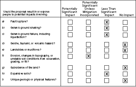
    Faults with the greatest potential for ground-surface rupture are those considered active by the state of California and which are zoned under the Alquist-Priolo Earthquake Fault Zoning Act. In the vicinity of the project area, the San Andreas Fault Zone is active, and could experience surface displacement in the event of an earthquake on its peninsula segment. The project area is not located within the fault rupture hazard zone for the San Andreas Fault Zone. Considering the distance from the San Andreas Fault Zone, there is a low potential that ground-surface rupture would occur in the project area during a San Andreas Fault Zone earthquake. It is possible that San Andreas Fault Zone activity could trigger secondary movement and possibly ground-surface rupture on the Monta Vista fault and in Berrocal Fault Zone. However, considering the distance of these faults, the potential for ground-surface rupture occurring is remote.

  2. The project site is located in the Santa Cruz Range foothills in the Coast Range Geomorphic Province, which is an area of high seismic activity. Several major northwest-trending faults, (especially the dominant San Andreas Fault Zone) and a number of smaller fault zones located within 40 miles, are anticipated to generate major earthquakes that could induce significant ground shaking in the project area. In addition to the San Andreas, the Monta Vista Fault and the Berrocal Fault Zone, other active and potentially active faults are listed in Table III-1.

    The main potential hazard to structures and people on site would be from ground movement associated with seismic activity. Because the substations would be fenced and locked, direct public access would be prevented. Therefore, no injuries to people on the substation properties would be expected to occur during earthquakes. Damage to PG&E power poles and lines from ground shaking is not anticipated. Although local surface failures can cause collapse of poles, evidence of unstable soils or slopes were either not identified or corrected prior to construction of the existing pole locations. The earthquake hazards are potentially significant only for the facilities themselves. To the extent that these would be rendered inoperable by an earthquake, resulting in a loss of power in the service area, the project could affect population in the service area. However, a major earthquake that could affect proposed project components also is likely to affect a wide area in the South Bay. By providing better linkage of power transmission in the area, the project likely would result in a net improvement to system reliability during and following a major earthquake.

    PG&E’s overhead and underground electrical facilities are constructed to exceed the safety standards established in the Commission’s General Orders, which generally far exceed the seismic load required to sustain a maximum credible earthquake. For example, utility poles built in accordance with General Order 95 are generally more than twice as strong as

    required to withstand the seismic load of a maximum credible earthquake. Compliance with these and the California Building Code would reduce groundshaking effects to levels of acceptable risk, and would result in a less than significant impact from groundshaking (PG&E, 1998).

TABLE III-1

LOCATIONS AND CHARACTERISTICS OF EARTHQUAKE FAULTS

THAT MAY AFFECT THE PROPOSED MONTA VISTA SITE


Causitive Fault


Approximate Time Since Last Activity

Approximate

Distance & Direction (miles)

Maximum Probable Magnitude

San Andreas (Loma Prieta segment)

Historic (1989)

4.5, East

7.25

San Andreas (San Francisco segment)

Historic (1906)

30, Northwest

8.0

San Gregorio/Hosgri

Holocene
(<11,000)

20, West

7.75

Hayward (southern segment)

Historic
(1836, 1868)

16, East

7.5

Calaveras (southern segment)

Historic (1861)

18, East

7.25

Sargent

Holocene
< 10,000

16, South

6.75

Berrocal

(Early Quaternary)
< 1.6 million

2, East

6.0

Monta Vista

(Late Quaternary)
< 700,000

2, North

6.5

_________________________

Source: ESA, 1997; PG&E, October 1998; Jennings, 1994.

  1. Earthquakes or aftershocks may cause secondary ground failures. Ground failures are caused by soil losing its structural integrity. Examples of seismically-induced ground failures are liquefaction, lateral spreading, ground lurching, and settlement. Liquefaction (the rapid transformation of soil to a fluid-like state) affects loose saturated sands. Earthquake ground shaking induces a rapid rise in excess pore pressure and the soil loses its bearing strength; it may spread laterally, undergo settlement and form fissures and sand boils (upwellings of sand at the surface). Lateral spreading is the horizontal movement of loose, unconfined sedimentary and fill deposits during seismic activity. Settlement is vertical downward movement of the ground surface resulting from the compaction of granular materials during seismic shaking.

    The project area susceptibility to liquefaction is considered low (ABAG, 1980). Localized areas of liquefiable materials are possible within the project area. However, the potential for ground failure would be evaluated by design-level geotechnical investigations, and if necessary, standard engineering design and construction practices typically used within areas with such soils would eliminate or minimize potential for damage due to liquefaction (PG&E, 1998).

  2. Earthquakes can cause tsunami ("tidal waves"), seiches (oscillating waves in enclosed water bodies), and landslide splash waves in enclosed water bodies such as lakes and reservoirs. Earthquakes can also result in dam failures at reservoirs. The project site is not located near an enclosed body of water (PG&E, 1998), and is outside the inundation zone from a dam failure at Stevens Creek Reservoir (ABAG, 1980). Therefore, there would be no impact from tsunami, seiche, or seismically induced dam failure related to the proposed project.

  3. The topography of the area ranges from nearly flat terraces and graded areas to gently rolling hills, with slopes generally less than 15 degrees. Local fill and creek bank slopes range up to 25 degrees (PG&E, 1998). Considering the topography and the granular, well-drained alluvial soils, potential for slope instability and consequential slope failure in the project area is low.

  4. Potential unstable soil conditions include settlement and failure from low strength soils. Project area soils are not of the types characterized by low strength. Settlement can occur either uniformly or differentially. Uniform settlement of a structure can cause poor drainage and potential failure of underground utility connections. Differential settlement can damage a foundation and cause mechanical and structural problems within a structure. The magnitude of fill settlement will depend on the quality of the fill material and the manner in which it is placed, the thickness of the fill, the type of subsurface soil and the load placed on the material. Settlement is anticipated to be minor within the project area. As standard engineering, design and construction practices are proposed, including compaction of engineered fills, impacts resulting from settlement would be minor and the hazard would be less than significant.

    The project site would require minimal to no additional grading of the flat site to construct the proposed substation and will not result in any changes in topography. Construction of the additional towers at the Monta Vista substation could disturb site soils and may be subject to erosion by rain splash and overland flow of stormwater for the duration of the construction activities. Site preparation would entail minor re-grading, resurfacing and paving of portions of the site. Because the site is flat, soil erosion from construction activities would not likely result in significant hazards of gully formation. Runoff from the site could entrain loose soil and discharge it into storm drains. While the hazard is deemed low, and less than significant, the impacts from erosion hazard could be reduced to an absolute minimum by implementation of standard erosion control measures. These control measures would include the following:

    · Maintaining construction setbacks of 100 feet from Stevens Creek, and 50 feet from Heney Creek.

    · All excavated materials would be hauled away immediately after excavation and no excavated materials would be stored on the sites.

    · PG&E’s standard construction methods include use of erosion control measures such as hay bales and silt fences to protect biological resources, roadways, and adjacent property (PG&E, 1998).

  • The proposed project would not require the removal of groundwater or any change in groundwater use. Therefore, there would be no impact related to ground subsidence.

  • Expansive soils can exhibit shrink-swell behavior. Shrink-swell is a cyclic change in volume that occurs in fine-grained sediments because of expansion and contraction of clay caused by wetting and drying. Soils that are expansive can damage foundations and structures. Due to their granular nature, the susceptibility of the project area soils to exhibit expansive properties and ultimately damage proposed and existing facilities is low. However, the extent of expansive soils, potential effects of these soils, and possible remedial measures would be evaluated by design-level geotechnical investigations. Design and construction measures would be taken to eliminate or minimize effects to a less than significant impact (PG&E, 1998).

  • The site is essentially flat and has no unique geological features. Therefore, there would be no impacts related to unique geologic or physical features (PG&E, 1998).

  • Applicant Proposed Mitigation

    Although all geologic impacts would be less than significant, PG&E proposes standard mitigation to be incorporated into the project.

    PG&E, in conjunction with other utilities and equipment vendors throughout the country, has revised IEEE 693, "Recommended Practices for Seismic Design of Substations" ("IEEE 693") to address equipment and voltage-specific seismic qualification requirements. These requirements are generally more stringent than the Uniform Building Code (PG&E, 1998). All equipment for the proposed project will be procured using the seismic qualification requirements of IEEE 693. In addition, PG&E will comply with all requirements set forth in General Orders 95 (overhead line construction) and 128 (underground electric line construction).

    General Order 128 was created to promote and safeguard public health and safety in the construction and maintaining of underground electrical and communications facilities. This set of rules is a foundation of broad principles upon which more detail and safe systems will be built. To ensure the proper design and construction of underground systems, important components of an underground system are analyzed for seismic stability, especially components mounted on above ground support structures. PG&E civil engineers and geologists will specify expected vertical and horizontal accelerations from expected local seismic events. Based on this data, manufacturers will provide data on the stability of the component under such conditions. Company geologists have also reviewed existing cable routes, looking for severe ground movements in seismic events that could jeopardize the integrity of the buried portion of the cable circuits (PG&E, 1998).

    TOP
    Forward to Next Section
    (Water)
    Back to Previous Section
    (Population and Housing)
    Back to Monta Vista/Wolfe/Stelling Looping Project Main Page CPUC Environmental Page CPUC Home Page