SECTION 4
ENVIRONMENTAL CHECKLISTS
4.1 LAND USE AND PLANNING
SETTING
The 12 Southern California Edison generating plants are located in Los Angeles, Orange, San Bernardino, Santa Barbara and Ventura counties. The following section examines land use and planning implications of the project within the context of the regions and communities in which generating stations are located.
Regional Setting
Huntington Beach
The Huntington Beach power plant is located in Orange County. More than 44% of the existing land in the county, representing the single largest land use category, is currently undeveloped in large part due to the topographical constraints of eastern Orange County. Of the remaining developed land within the county, 22% is devoted to low density residential uses, and six percent multi-family residential uses. Commercial and public facilities and institutional land uses represent the next largest land use category in the region, each accounting for about five percent of its developed area.
Planned land uses in this region consist of 38% designated for open space and recreational uses and 33% designated for non-urban and low density residential uses. The remaining one-third of the region is planned for the following uses: public facilities and institutions (eight percent), medium and high density residential (seven percent), industrial (six percent) and commercial uses (five percent). Less than one percent of the region is planned for agricultural. Based on projected growth in residential uses in the region, additional planning for employment generating uses, such as commercial and industrial developments, will assist the local jurisdictions in maintaining a balanced mix of use patterns.
Cool Water, Etiwanda, Highgrove, and San Bernardino
The Cool Water, Etiwanda, Highgrove, and San Bernardino generating plants are located in San Bernardino County. Due to the large overall land area and the prevalence of federal and state owned lands, existing land uses within the region are predominantly agricultural, vacant, or in recreational open space lands. Urban land uses occupy a relatively small fraction of the total region. Single-family residential uses, for example, comprise only two percent of the region's total land area. Commercial land uses comprise less than one percent and industrial areas less than one percent. In contrast with such small percentages is the fact that total acreages in residential and industrial uses are greater numerically than comparable acreages in the City of Los Angeles.
General plan patterns tend to reflect an extension of existing land use patterns. However, substantial acreages exist to provide extensive new urban and suburban growth, depending upon market forces and local policy. The region's urban areas are likely to remain predominantly in single-family residential uses, with accelerated multi-family, commercial and industrial growth.
Alamitos and Long Beach
The Alamitos generating plant and Long Beach power plant are located in southeast Los Angeles County. Approximately five percent of the area is vacant, 41% is occupied by low-density residential uses, 14% industrial, nine percent medium/high density residential and transportation/utilities, eight percent commercial, and six percent public facilities and institutional land uses. As shown by the above land use characteristics, the region is a highly urbanized, mixed use area with relatively little available vacant land. Therefore, not including redevelopment potential, this region is virtually built-out. Although residential land uses are scattered throughout the region, commercial areas tend to be linear, located along roadways. Industrial uses are generally located adjacent to freeway and major arterial intersections.
Approximately 40% of the region is planned for low density residential uses with an additional 19% planned for industrial uses. Medium to high density residential, open space and recreation, commercial, and public facilities and institutions are also predominant uses in the region's general plans. Because of the existing relatively high urban density in the region, coordinated land use planning between the jurisdictions is necessary to reduce the potential for conflict that results from locating incompatible uses adjacent to one another.
El Segundo and Redondo
The El Segundo and Redondo power plants are located in the south bay area in Los Angeles County. Existing land uses within this region represent a greater mixture of land uses also reflecting a generally built-out condition. Low density residential uses still are the largest single land use category, comprising 25% of the region's total land area. Commercial land uses represent five percent and industrial areas nine percent. Vacant and agricultural lands represent only six percent of the region and open space and recreation lands three percent. Significant industrial concentrations are found in this region, generally in association with railroad lines and refineries. The region has long been a major center for oil refineries and in more recent decades for aerospace and defense industries.
General plan land use patterns reflect a general continuation of the existing patterns of residential, commercial and industrial uses. A residual supply of open space and recreation lands of three percent of the region is estimated at buildout.
Mandalay and Ormond Beach
The Mandalay and Ormond Beach power plants are located in Ventura County. Approximately 80% of the lands within Ventura County are vacant or undeveloped. An additional one percent is occupied by open space and recreational land uses. Approximately 10% of the area is currently occupied by agricultural uses, while an additional five percent are currently in low density residential uses. The majority of the vacant land is located in the northern portion of the county while developed lands, though fairly scattered, are located in the southern portion. Smaller portions of lands are devoted to commercial and industrial land uses, and are located almost exclusively in the southern half of the region, including Mandalay and Ormond. The coastal portion of the region is relatively undeveloped; single-family residential, public facilities, institutions, scattered commercial and office uses, and open space and recreational uses are the predominant existing land uses.
The general plans for the region have anticipated and accommodated growth by providing for a mix of uses that continue existing land use patterns. Additional land area within the city limits, planned for residential, industrial, commercial and mixed urban uses, is available in this region to accommodate projected growth. Further, substantial amounts of open space and agricultural lands are available for annexation and incorporation into the municipal planning areas to accommodate projected urban growth.
Ellwood
The Ellwood Energy Support Facility is located in the County of Santa Barbara. Land uses in the county are widely varied and dominated by a variety of residential uses. Commercial uses are concentrated almost entirely along the main east-west traffic corridors. The land use plan allows for the continued expansion of the region's commercial base on vacant or undeveloped lands. The region also has a diverse industrial base and agricultural lands that created new jobs which have outpaced the production of new housing. Approximately 21% of the region is planned for commercial and industrial uses with an additional 16% is planned for residential uses.
Local Setting
Alamitos
The Alamitos generating plant an located is a 234-acre site at 690 North Studebaker Road in the southeastern portion of the City of Long Beach. Additional facilities on the site include the Edison Pipeline & Terminal Company (EPTC), a desalination plant, and an active nursery. The project site and surrounding area are under the jurisdiction of several local plans, including the Long Beach General Plan, the Southeast Development Improvement Plan (SEADIP), and the Long Beach Local Coastal Program. The SEADIP Plan has been incorporated by reference into the Long Beach Local Coastal Program.
Cool Water
The Cool Water generating station is an approximately 2,400-acre site at 3700 Sante Fe Road in the unincorporated community of Daggett, within San Bernardino County's North Desert region. In addition to the generation facility, the site accommodates a farm, Daggett Leasing, the Los Angeles Department of Water and Power (LADWP) Hoover transmission line, the Solar Two solar generating project, and Airco. The project site and surrounding area fall under the jurisdiction of the San Bernardino County General Plan.
Ellwood
The Ellwood facility is located on a 3.5-acre site at 30 Los Armas Road in the unincorporated Santa Barbara County community of Goleta. No other developed uses occupy the Edison property. The project site and surrounding area fall under the jurisdiction of the Santa Barbara County Comprehensive Plan and the Goleta Community Plan.
El Segundo
The El Segundo generating station is located on a 33-acre site at 301 Vista Del Mar Road in the City of El Segundo. In addition to the generating station, the site contains a park facility. The project site falls under the jurisdiction of the El Segundo General Plan and the El Segundo Local Coastal Program.
Etiwanda
The Etiwanda plant is located on a 209-acre site at 8996 Etiwanda Avenue in the City of Rancho Cucamonga, in the West Valley region of San Bernardino County. Of the 209 acres occupied by Edison, 86 acres are vacant land and 4 acres house the Edison Pipeline and Terminal Company. The project site and surrounding area fall under the jurisdiction of a variety of local plans, including the City of Rancho Cucamonga General Plan and the Industrial Area Specific Plan.
Highgrove
The Highgrove plant is located on a 79-acre site at 12700 Taylor Street in the City of Grand Terrace, in the East Valley region of San Bernardino County. A local municipal park, Cage Park, occupies a portion of the site. The project site falls under the jurisdiction of the City of Grand Terrace General Plan, as do most adjacent properties. Lands bordering the southernmost site boundary are subject to the Riverside County General Plan.
Huntington Beach
The Huntington Beach generating facility is located on a 106-acre site at 21730 Newland Street in the southeastern portion of the City of Huntington Beach. In addition to the generating station, the site accommodates a desalination test plant and coastal wetlands. The project site and surrounding area fall under the jurisdiction of the Huntington Beach Draft General Plan dated December 12, 1995, and the Huntington Beach Local Coastal Plan.
Long Beach
The Long Beach facility is located on a 43-acre site at 2665 West Seaside Boulevard on Terminal Island in the City of Long Beach. In addition to the generating station, the property contains the 14-acre Edison Pipeline and Terminal Company. The project site and surrounding area fall under the jurisdiction of a variety of local plans, including the City of Long Beach General Plan, the Long Beach Local Coastal Program, and the Port of Long Beach's Port Master Plan. Activities within the boundaries of the Port of Long Beach are primarily designated and controlled by the Port Master Plan. Consequently, the City's General Plan relegates all but the most general discussion of the Port to the Port Master Plan and contains no goals, objectives, or policies relevant to the Long Beach facility. Furthermore, although the generating station falls within the Coastal Zone, the City's Local Coastal Program does not address the Port area directly; instead, the Port Master Plan fulfills the State's Coastal Program requirements for the Port District and is incorporated by reference into the Local Coastal Program.
Mandalay
The Mandalay generation facility is located on a 205-acre site at 393 North Harbor Boulevard in the City of Oxnard in central Ventura County. The project site falls under the jurisdiction of the City of Oxnard 2020 General Plan and the City of Oxnard Coastal Land Use Plan.
Ormond Beach
The Ormond Beach generating station is located on a 693-acre site at 6635 South Edison Drive in the southern portion of the City of Oxnard, Ventura County. In addition to the generating station, the site contains farmland, wetlands, and a mariculture laboratory. The mariculture laboratory has been used by Edison and consulting scientists to conduct marine research. Topics of study have included the use of heated effluent to increase growth rates of lobsters, abalone and white sea bass; and studies to determine the feasibility of developing profitable aquaculture ventures associated with the generating station. No Edison-sponsored research is currently underway at the facility, but consultants maintaining the lab are conducting in-plant fish impingement monitoring required by the station's National Pollutant Discharge Elimination System (NPDES) permit. The facility occupies approximately one quarter acre near the intake screen wells on the west side of the facility.
The Ormond plant is under the jurisdiction of the City of Oxnard and the County of Ventura. The parcels that are located within the County's jurisdiction are undeveloped farmland parcels. The generating station portion of the site is under the City of Oxnard's jurisdiction. Although some of the undeveloped parcels are under the jurisdiction of the County, they are within the "sphere of influence" of the City of Oxnard. A sphere of influence provides a plan for the probable ultimate physical boundaries and service area of a local agency. Properties located within a city's sphere of influence may be annexed into such city after following the procedures provided for in the California Government Code. This designation is a necessary prerequisite for annexation.
Redondo
The Redondo plant is a 56-acre site at 1100 Harbor Drive in the City of Redondo Beach. Additional land uses situated on the site include a railroad right-of-way, the Redondo Marine Biology Laboratory, and the Redondo Marine Education Center. The laboratory and education center occupy the plant 1 (Units 1-4) pump room and screen well areas. The facilities are located in a compound west of the generating station and separated from the station by Harbor Drive. Ownership of the Marine Education Center is encumbered by a settlement agreement between Edison and Earth Island Institute. The agreement stipulates that Edison will renovate the facility and provide additional funds for development of an education plan. The renovation and education plan are now complete. The agreement also requires Edison to support operation of the facility for 10 years and provide $400,000 per year to the facility to cover operating expenses. The 10-year obligation commenced August 15, 1996. The facility is operated jointly by Edison and Earth Island Institute with the goal of providing marine education and career development opportunities to disadvantaged youth. The project site falls under the jurisdiction of a variety of local plans, including the City of Redondo Beach General Plan and the City of Redondo Beach Harbor/Civic Center Specific Plan. The project site is within the California Coastal Commission's Coastal Zone. The City does not have a fully certified Local Coastal Plan; therefore, the Coastal Commission retains permitting authority for land use changes at the plant.
San Bernardino
The San Bernardino generating station is a 103-acre site at 25770 San Bernardino Avenue, just outside of the City of San Bernardino, in an unincorporated area of San Bernardino County. Portions of the site are currently used as farmland. The site is surrounded by incorporated areas of the City of Redlands on the north, east, and south and the City of San Bernardino on the west. The San Bernardino generating station is under the jurisdiction of the County of San Bernardino (the "County") and the City of Redlands. The power plant site is located within an unincorporated area of San Bernardino County and is under the County's jurisdiction. The eastern portion of the property, which is used for agricultural purposes, is located within the City of Redlands.
CHECKLIST ISSUES
a) General Plan Designations and Zoning
Alamitos
The City of Long Beach General Plan designates the power plant property as Land Use District (LUD) No. 7, Mixed Use District. The range of land uses allowed within this district includes employment centers, such as retail, offices, and medical facilities; higher density residences; visitor-serving facilities; personal and professional services; and recreational facilities (City of Long Beach, 1989). Uses that may have a detrimental effect on the ambiance, environment or social well-being of the area are not intended for inclusion in the district (City of Long Beach, 1989). Such uses consist of industrial and manufacturing uses, warehousing activities, and outside storage (City of Long Beach, 1989). In addition, the General Plan contains the following stipulation regarding appropriate and inappropriate uses:
[The determination of appropriate uses] is not to preclude the assignment of this district designation to areas which have as their base industrial/manufacturing/warehousing uses. In these cases, the appropriate accompanying land uses include offices, visitor-serving uses, retail and restaurants, and services, all for the purpose of supporting the working population within the district complex. Along major thoroughfares in this district, large-scale wholesale and retail uses may be appropriate, as permitted by the respective planned development ordinances. Residential uses are not permitted in these cases. (City of Long Beach, 1989.)
Thus, it appears that the District permits properties with industrial/ manufacturing/warehousing uses as their base use.
The City of Long Beach has adopted a Local Coastal Program ("LCP") pursuant to the California Coastal Act. The facility lies within the Coastal Zone and is designated as PD 1 - Planned Development District, Subarea 19 pursuant to the LCP. The LCP requires a coastal development permit or exemption from such permit for development of property. The facility is also located within the Southeast Area Communities ("SEADIP") area, which is administered by a Specific Plan and Planned Development Ordinance allowing "residential, commercial and recreational" uses.
Within the SEADIP, Subarea 19 is designated as Industrial and the SEADIP states that "this area is fully developed in accordance with the provisions of the MG Zone." The MG Zone has subsequently been changed to the "IG" designation. The IG zone, as described in Title 21 of the Long Beach Municipal Code ("LBMC"), allows a wide range of industrial uses. "Electrical services," defined as "establishments engaged in the generation, transmission, and/or distribution of electrical energy for sale," are allowed in the IG zone, subject to a conditional use permit for such use (LBMC, Table 33-2).
Cool Water
The Cool Water plant is located in an unincorporated area of San Bernardino County and is under the jurisdiction of the County of San Bernardino. Under the County's General Plan, the area encompassing the Cool Water generating station is designated for Regional Industrial ("IR") land uses. The purposes of the IR designation are (1) to identify and establish areas suitable for major industrial centers or a single large industrial plant; (2) to provide sites for industrial uses which have severe potential for negative impacts on any nearby uses, and (3) to identify areas intended to be eventually utilized for industrial purposes (General Plan, II-D6-22). The General Plan states that this designation is applied to areas of existing industrial uses and areas adjacent to major energy facilities. The General Plan does not define "major energy facilities." This facility is not subject to any General Plan Overlay designations.
The zoning requirements applicable to the Cool Water generating station are found in the San Bernardino County Development Code. According to the San Bernardino County zoning maps, the Cool Water generating station is located in the Regional Industrial ("IR") Zone. The Development Code lists the permitted and conditionally permitted uses in the IR Zone (Sec. 84.0375). This section of the code does not list generating stations or switchyards as either permitted or conditionally permitted uses. The Development Code provides for the establishment of Additional Uses, including new electrical generating stations and electrical substations, in any zone, subject to one of two review processes (Sec. 84.0410(1)). The storage of fossil fuels is listed as a conditionally permitted use in the IR zone under Sec. 84.0240(a)(2). The Development Code permits the establishment of this use with the approval of a conditional use permit by San Bernardino County (Sec. 84.0401). In addition, the Development Code provides for the establishment of this use with the approval of a federal or state agency (including the State Energy Commission), subject to certain additional requirements described in the Development Code (Sec. 84.0405).
Ellwood
The Ellwood facility is subject to the jurisdiction of the County of Santa Barbara. Pursuant to the Santa Barbara County Goleta Community Plan, the facility site is designated as Public Utility ("UT"). The Santa Barbara County Comprehensive Plan defines the Public Utility designation as "an area designated for the facilities and service of a public utility or public service entity." The balance of the property is designated Industrial Park with a Proposed Public or Private Park Recreational Facility Overlay.
The County of Santa Barbara Inland Zoning Ordinance designates the applicable zoning requirements for the site. The zoning designation for the generating station site is Public Works, Utilities and Private Service Facilities ("PU"). The zoning designation for the balance of the property is Industrial Research Park ("M-RP"). Zoning Ordinance Sec. 35-238.1 states that the purpose of the PU zone is "to provide areas for the siting of large scale public works, utilities and private service facilities appropriate for location in the PU district." Under the Definitions section of the Zoning Ordinance, the term "private services" is defined as "all production, storage, transmission, treatment and recovery facilities for water, sewerage, energy and other similar utilities and facilities owned or operated by any business organization, person or private entity. . . ." The permitted uses on PU-zoned sites include "operating bases and service centers for public utilities" and "major electric transmission substation." (Zoning Ordinance Section 35-238.4).
El Segundo
The El Segundo site is subject to the jurisdiction of the City of El Segundo, and the applicable zoning for the site is designated by the City of El Segundo Subdivision and Zoning Code. Under the City's Zoning Code, the facility is zoned as Heavy Industrial ("M-2"). Permitted uses under this zoning designation include "generating stations." This use does not require a conditional use permit.
The El Segundo generating station is also located in the Coastal Zone and is therefore subject to the City of El Segundo Coastal Zone Specific Plan. Pursuant to the Coastal Zone Specific Plan, the facility site is zoned as Power Plant ("PP"). The uses listed under the PP designation include "Energy Generating Station" and "accessory buildings and uses customarily incidental to [use as an energy generating station] when located on the same site with the main facility."
Properties south of the El Segundo site within the City of Manhattan Beach carry a land use designation of High Density Residential. Typical uses allowed under the High Density Residential designation include residential densities up to 65 dwelling units per acre.
Etiwanda
The Etiwanda site is under the jurisdiction of the City of Rancho Cucamonga. Pursuant to the Land Use Element of the City's General Plan, the site has a Heavy Industrial designation. The General Plan describes Heavy Industrial uses as "generally large scale developments whose activity includes heavy manufacturing, compounding, processing or fabrication" and may also include warehousing, storage, freight handling, truck services and terminals. The General Plan provides that specific uses in Heavy Industrial areas will be defined in the Industrial Specific Plan, as discussed below.
The specific zoning requirements for the Etiwanda site are set forth in the City's Industrial Specific Plan ("ISP"). The property is within Subarea 15 of the ISP. The corresponding zoning designation is Heavy Industry. Conditionally permitted uses in Subarea 15 include "Extensive Impact Utility Facilities," "Utility Services," and "Petroleum Storage." The City of Rancho Cucamonga has not issued any conditional use permits for the site since the incorporation of the City.
Prior to incorporation of the City, the site was subject to the jurisdiction of San Bernardino County. On November 10, 1950, a permit was granted to Edison by the San Bernardino County Board of Supervisors. The permit was for the "erection, construction, operation, maintenance, occupancy and use" of the property for a steam electric generating station, with switchyard and appurtenant facilities.
Highgrove
The Highgrove generating station is subject to the jurisdiction of the City of Grand Terrace. Under the Land Use Plan of the City of Grand Terrace's General Plan, the area encompassing the entire Highgrove property is designated for Light Industrial uses. The General Plan describes Light Industrial uses as "[n]on-polluting, light manufacturing, warehousing, and distribution uses," including a wide range of industrial uses that would be constructed under special industrial development standards, as provided for in the City of Grand Terrace Zoning Code. The General Plan further provides that only light non-polluting industrial uses shall be allowed in Grand Terrace. The General Plan discussion of Light Industrial land uses recognizes two Southern California Edison facilities within the City, the subject generating station and a switching substation at the northern border of the City.
According to the City of Grand Terrace Zoning District Map, the Highgrove generating station site is located in the Industrial District ("M2") zone. The Grand Terrace Zoning Code states that the purpose of the M2 zone is to provide for the development of medium manufacturing and industrial uses. Zoning Code Sec. 18.40. This designation includes "various manufacturing and industrial uses which operate free of overly excessive noise, dust, odor or other nuisances and yet may be objectionable to other (non-industrial) districts." The Permitted Uses (Sec. 18.40.020 ) and Conditionally Permitted Uses (Sec. 18.40.030) sections of the Grand Terrace Zoning Code do not expressly list electrical generating stations or similar facilities, fuel tanks or switchyards as either permitted or conditionally permitted uses in the M2 zone.
The Grand Terrace Zoning Code provides for an Unlisted Use Determination ("UUD") for uses which are not listed as permitted or conditionally permitted uses. This involves review of the use by the Planning Commission for its determination of whether the use is permitted, conditionally permitted or prohibited in a certain zoning district. No discretionary approvals concerning the property were identified during an inspection of the City's records.
A portion of the property located to the east of Taylor Street is zoned Restricted Manufacturing ("MR"). The easternmost portion of the property located along Pico Street, licensed to the City of Grand Terrace for use as a park, is zoned Public Facilities District ("PUB"). The use of these properties appears to be unrelated to the generating facility uses.
Huntington Beach
The Huntington Beach plant is subject to the jurisdiction of the City of Huntington Beach. According to the City of Huntington Beach's draft General Plan dated December 12, 1995, the area encompassing the facility is designated as "Public," with a small portion of the site designated as "Industrial." The General Plan defines uses permitted under the Public designation to include "Governmental, administrative and related facilities such as public utilities, schools, public parking lots, infrastructure, religious and similar uses." Uses permitted under the Industrial designation include "light manufacturing, research and development, warehousing, business parks and professional offices, supporting retail, financial and restaurants, and similar uses, warehouse and sales outlets." The infrastructure of the facility, including the switchyard and other accessory uses, are located within the "Public" designation.
The property encompassing the facility is zoned "IG O FP2 CZ" under the City of Huntington Beach Zoning and Subdivision Ordinance, ("HBZSO"). The property is also located within the designated Coastal Zone and subject to the City's LCP.
The "IG" or Industry General zone classification includes power generation. The IG zone allows "Utilities, major" as a use permitted with a conditional use permit approved by the planning commission. Accessory uses and structures are permitted with respect to such permitted use, but these uses require a conditional use permit. "Utilities, major" is defined as "[g]enerating plants, electrical substations, above-ground electrical transmission lines, switching buildings, refuse collection, transfer, recycling or disposal facilities, flood control or drainage facilities, water or wastewater treatment plants, transportation or communications, utilities, and similar facilities of public agencies or public utilities."
The "O" designation for the site refers to an Oil Production Overlay District which, among other things, requires a re-use plan before any land division or development may occur. The "FP2" designation for the site refers to a Flood Plain Overlay District which applies to all areas of special flood hazard within the City and development in FP2 areas must comply with provisions of this district designation. The "CZ" designation refers to the Coastal Zone Overlay District, which means that a coastal development permit is required for development of any property under the LCP unless it is exempt or categorically excluded, as provided for in HBZSO Sections 245.08, 306.1b(e) and 306.10.5.
Long Beach
The Long Beach generating station is subject to the jurisdiction of the City of Long Beach. Under the City of Long Beach General Plan, the area encompassing the Long Beach generating station is designated as Land Use District No. 12 - Harbor/Airport. The General Plan states that the land uses within these areas should support and promote primary functions appropriate to each subdistrict.
The Long Beach property is located within the Port of Long Beach area. Land uses within the boundaries of the Port of Long Beach are designated and controlled by the Port Master Plan and the Port's Local Coastal Program, which is incorporated into the City's LCP. Under the Port Master Plan, the property is located within District 3, North West Harbor Planning District which allows "Utilities" as a permitted use.
Under the Long Beach Municipal Code, the property is zoned IP-Port Industrial. Uses in this designation are primarily port-related or water-dependent, but also may include: "water oriented commercial and recreational facilities primarily serving the general public, and utility installations and rights of way." A coastal development permit is also required for the development of this property under the LCP. Projects in the IP district are subject to review by the Harbor Department. Utilities, defined as "installations and rights of way, including the Edison station on Terminal Island," (i.e., the Long Beach Generating Station) is a class of use that is permitted by right.
Mandalay
The Mandalay power plant is subject to the jurisdiction of the City of Oxnard. Under the City of Oxnard General Plan 2020, the area encompassing the Mandalay generating station is designated as an Industrial Area Public Utility/Energy Facility. Under the General Plan description, a Public Utility/Energy Facility designation "applies to the Southern California Edison electrical generating and transmission facilities located within the City as well as facilities related to oil and gas development within the City."
The City of Oxnard has developed an LCP and the Mandalay plant lies within the Coastal Zone. Pursuant to the LCP, the applicable land use designation for the site is found in the City of Oxnard Coastal Zoning Ordinance ("CZO"). The City of Oxnard Zoning Map designates a large portion of the site as Coastal Energy Facilities Zone ("EC"), with a designation of Coastal Recreation Zone ("RC") for the western portion of the site immediately adjacent to the coastal beach area. The generating station is located within the EC zone. CZO Sec. 37-2.11.0 states that the purpose of the EC zone is to provide areas that allow for "siting, construction, modification and maintenance of power generating facilities and electrical substations." CZO Sec. 37-2.11.2 lists the following conditionally permitted uses for this site: (1) off-street public parking facility; (2) electrical power generating plant and accessory uses normally associated with power-generating facility; (3) electrical sub-station; and (4) natural gas pumping and extraction facilities.
Portions of the Edison owned facilities are located within the County of Ventura and are within the County Local Coastal Plan. These areas are designated as Coastal Open Space and are zoned C-O-S in the Coastal Zoning Ordinance (Turner, 1997).
Ormond Beach
Under the City's General Plan 2020, the area encompassing the generating station is designated as an Industrial Area - Public Utility/Energy Facility. A Public Utility/Energy Facility designation "applies to the Southern California Edison electrical generating and transmission facilities located within the City as well as facilities related to oil and gas development within the City."
Like the Mandalay generating station, the Ormond plant lies within the City of Oxnard Coastal Zone and the applicable land use designation for the site is found in the CZO. The Zoning Map designates the Ormond Generating Station as predominantly Coastal Energy Facilities Zone ("EC"). The generating station is located in the EC-zoned portion of the site. A small area on the westerly portion of the site is designated as a Coastal Resource Protection Zone ("RP"). Additionally, a small area on the eastern corner of the site which is located beyond the Coastal Zone is zoned as Heavy Manufacturing ("M-2") under the City of Oxnard Zoning Ordinance. One of the permitted uses listed pursuant to this zoning designation is "steam electric generating stations operated by gas or fuel."
CZO Sec. 37-2.11.0 states that the purpose of the EC zone is to provide areas that allow for "siting, construction, modification and maintenance of power generating facilities and electrical substations." Section 37-2.11.2 lists the conditionally permitted uses for EC zoned sites. The conditionally permitted uses listed in this Section are: (1) off-street public parking facility; (2) electrical power generating plant and accessory uses normally associated with power-generating facility; (3) electrical sub-station; and (4) natural gas pumping and extraction facilities.
Portions of the Edison owned facilities at the Ormond Beach station are also located within the County of Ventura and are within the County Local Coastal Plan. These areas are designated as Coastal Open Space and are zoned C-O-S in the Coastal Zoning Ordinance (Turner, 1997).
Redondo
The Redondo generating facility is under the jurisdiction of the City of Redondo Beach. Pursuant to the Land Use Element of the City's General Plan, the site has a Public and Institutional ("P") designation. The General Plan describes this designation as being "comprised of lands for the P designation that are owned by public agencies, special use districts and public utilities." The permitted uses described in the General Plan are to "accommodate governmental administrative facilities. . . public utility and infrastructure, public and private secondary uses. . . ." General Plan Section 1.46.1. In addition, Section 1.46.2 states that as permitted uses, the P designation will "allow for the reuse of public and utility properties for private use . . .with the type and density/intensity of use to be permitted on the site determined by . . ." factors such as compatibility with adjacent uses and revenue contribution to the City.
The facility is located within the Harbor/Civic Center Specific Plan's Catalina Avenue Sub Area Policy Zone 2. The primary land use for the region encompassing the site is "Public Utility Land Uses, subject to the granting of a Conditional Use Permit (including, but not limited to, facilities, structures, equipment, and storage related to the operation of a public utility) to the extent determined to be legally permissible. Minor additions or changes may be exempted from the requirement of a Conditional Use Permit." In addition, the Supplemental Land Use Policies for the site state that "[i]n anticipation of the end of the useful economic and physical life of the Southern California Edison Company Generating Plant, take necessary steps within an appropriate time frame to establish a plan for the comprehensive reuse of the site for non-industrial uses."
The City of Redondo Beach Zoning Ordinance defines the zoning designation for the generating station. Map 9 of the City's Zoning Map designates the site as Public-Generating Plant ("P-GP"). Zoning Ordinance Sec. 10-2.1114. One of the permitted uses pursuant to its designation is "public utility facility." This designation is defined in the ordinance as "a building or structure used or intended to be used by any public utility including, but not limited to, any gas treatment plant, reservoir, tank or other storage facility, water treatment plant, well, electric generating plant, distribution or transmission facility, any storage yard for public utility equipment." This use requires a conditional use permit. Zoning Ordinance Sec. 10-2.1110. In addition, accessory uses and structures in the P-GP zone are subject to special use regulations applicable to public utility facilities. Zoning Ordinance Sec. 10-2.1111. Pursuant to Sec. 10-2.1614, conditional use permits are required for modifications and additions to public utility facilities.
San Bernardino
Under the County's General Plan, the area encompassing the San Bernardino generating station is designated for Regional Industrial ("IR") land uses. The Land Use Element of the General Plan states that the purpose of the IR designation is: (1) to identify and establish areas suitable for major industrial centers or a single large industrial plant; (2) to provide sites for industrial uses which have severe potential for negative impacts on any nearby uses; and (3) to identify areas intended to be eventually utilized for industrial purposes. San Bernardino County General Plan, II-D6-22. The General Plan states that the IR designation applies to areas of existing industrial uses and areas adjacent to major energy facilities. The General Plan does not define "major energy facilities."
The General Plan applies two Liquefaction Hazard Overlay designations to the property. The southern portion of the facility, generally occupied by fuel tanks and the switchyard, is designated as being within a low liquefaction susceptibility area and the northern portion of the property, generally occupied by the property cooling towers, is designated as being within a medium susceptibility liquefaction area. Pursuant to Policy GE-12 of the General Plan, power plants are considered unsuitable uses in medium susceptibility areas. As such, new power plants are prohibited within these designated areas unless site investigation demonstrates that the site is suitable or that hazards will be adequately mitigated.
The San Bernardino County Development Code (the "Development Code") designates the zoning requirements applicable to the San Bernardino Generating Station. According to the San Bernardino County zoning maps, the San Bernardino Generating Station is located in the Regional Industrial ("IR") Zone. Section 84.0375 of the Development Code lists the permitted and conditionally permitted uses in the IR zone. This section of the code does not list generating stations as either a permitted or conditionally permitted use. The storage of fossil fuels is listed as a conditionally permitted use in the IR zone under Sec. 84.0240(a)(2). Section 84.0410(1) of the Development Code (concerning Additional Uses) provides for the establishment of electrical generating stations and electrical substations in any zone, subject to one of two review processes. The Development Code permits the establishment of this use with the approval of a conditional use permit by the County (Sec. 84.0401). The Development Code also provides for the establishment of this use with the approval of a federal or state agency (including the State Energy Commission), subject to certain additional requirements (Sec. 84.0405). No record of any discretionary approval for the use of the property was identified during an inspection of the County's records concerning this property.
The Development Code requires an administrative Land Use Compliance Review for development permits on sites that were subject to a conditional use permit or that were legally established prior to establishment of regulations that required the approval of a conditional use permit or similar authorization. Sec. 83.030305.
The eastern portion of the San Bernardino Generating Station property is located within the incorporated City of Redlands. This portion of the property is designated for Commercial-Industrial ("IC") by the City of Redlands' General Plan. The property is located within the East Valley Corridor Specific Plan - Concept Area 2. Under this Specific Plan, the property is zoned Regional Industrial ("IR"). Under this designation, public utilities and services are permitted with approval of a conditional use permit. The portion of the property located within the City of Redlands is currently used for agricultural purposes.
Conclusion
The 12 generation facilities indicated for divestiture are in areas zoned and designated for uses that include power generating facilities, generally as a conditionally permitted use. Edison is not proposing modifications to any permits to be transferred or reissued to the new owners, nor is it proposing changes to current land use designations or zoning for any of the plants.
Although the plants are consistent (or, in the case of the Highgrove site in Grand Terrace, not inconsistent) with the uses intended under the applicable general plans and zoning ordinances, the new owners may in some instances need to obtain certain entitlements (such as conditional use permits), and the local agencies may need to alter portions of their general plans and zoning ordinances to reflect the fact that the power plants will no longer be owned by public utilities or that the properties have been subdivided.
In the case of the properties not included in this divestiture application at the Redondo Beach plant, the continued use of this land for fuel oil storage would be consistent with the P-GP use designation. The change in ownership of a portion of land does not involve a change in the land use nor the vested right of Edison to use the land as historically designated.
CEQA Guidelines Section 15382 defines significant effect on the environment as "a substantial, or potentially substantial, adverse change in any of the physical conditions within the area affected by the project, including land, air, water, minerals, flora, fauna, ambient noise, and objects of historic or aesthetic significance" (emphasis added).
Nonconformance of a proposed land division with local zoning and general plan designations would not in itself directly entail any change in conditions in the physical environment. The division of Edison properties into parcels to be retained and parcels to be divested would therefore not in itself result in a change in physical conditions that would constitute a significant impact under CEQA. No change in physical conditions would occur directly as a result of such a land division.
Moreover, no substantial adverse change in physical conditions may be reasonably expected to result indirectly from a land division, or subsequent change in ownership, because substantial changes in the nature, type, and intensity of the current uses of the subject lands would not flow from the division of land or change in ownership.
Any physical alterations to the divided properties that would be associated indirectly with land division and subsequent change in ownership (e.g. impaired access) could be avoided by conditions of property sale or transfer (e.g. provision of access easements) to ensure that any adverse change would not occur. Note that where a land division requires discretionary approval by the local land use jurisdiction, the land division must conform to the applicable zoning and general plan designations, before it may be approved. If the land division as proposed is not in conformance with zoning, building, or general plan requirements, either the land division must be changed to conform to the requirements, or the requirements must be changed to conform to the land division. Regardless of which occurs, the land division and the requirements will be in conformance before the land division may be approved.
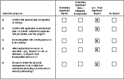
Since no substantial land use or zoning conflicts would occur as a result of this project, the project would have a less-than-significant impact related to general plan designation and zoning.
b) Applicable Environmental Plans
For a full discussion of the 12 Edison generating station's consistency with the applicable environmental plans, please see corresponding sections of this Initial Study (e.g., Air Quality, Biological Resources, Noise, etc.) and section (a) above concerning compliance with local coastal plans. No new construction is foreseeable as a result of the project. With or without divestiture, the uses at each site would be expected to remain the same.
Edison proposes to reparcelize several of the plants, which would involve a modification of lot lines. The proposed lot line adjustments conform to all jurisdictional zoning requirements including development standards for street frontage, minimum lot area width, building set backs, floor area ratios, parking, and loading.
Alamitos
The Alamitos generating station is consistent with the land use designated by the City of Long Beach General Plan. A review of the environmental impact reports for the general plan and also the Southern California Association of Government's Regional Comprehensive Plan and Guide indicates no conflicts with applicable environmental plans or policies at the local and regional level.
Cool Water
The Cool Water generating station is consistent with the land use designated by the County of San Bernardino General Plan. A review of the environmental impact reports for the general plan and also the Southern California Association of Government's Regional Comprehensive Plan and Guide indicates no conflicts with applicable environmental plans or policies at the local and regional level.
Ellwood
The Ellwood facility is consistent with the land use designated by the County of Santa Barbara for the Goleta Community Plan. A review of the environmental impact report for the general plan indicates no conflicts with applicable environmental plans or policies at the local level.
El Segundo
The El Segundo generating station is consistent with the land use designated by the City of El Segundo General Plan. A review of the environmental impact reports for the general plan and also the Southern California Association of Government's Regional Comprehensive Plan and Guide indicates no conflicts with applicable environmental plans or policies at the local and regional level.
Etiwanda
The Etiwanda generating station is consistent with the land use designated by the City of Rancho Cucamonga General Plan. A review of the environmental impact reports for the general plan and also the Southern California Association of Government's Regional Comprehensive Plan and Guide indicates no conflicts with applicable environmental plans or policies at the local and regional level.
Highgrove
The Highgrove generating station is consistent with the land use designated by the City of Grand Terrace General Plan. A review of the environmental impact reports for the general plan and also the Southern California Association of Government's Regional Comprehensive Plan and Guide indicates no conflicts with applicable environmental plans or policies at the local and regional level.
Huntington Beach
The Huntington Beach generating station is consistent with the land use designated by the City of Huntington Beach General Plan. A review of the environmental impact reports for the general plan and also the Southern California Association of Government's Regional Comprehensive Plan and Guide indicates no conflicts with applicable environmental plans or policies at the local and regional level.
Long Beach
The Long Beach generating station is consistent with the land use designated by the City of Long Beach General Plan. A review of the environmental impact reports for the general plan and also the Southern California Association of Government's Regional Comprehensive Plan and Guide indicates no conflicts with applicable environmental plans or policies at the local and regional level.
Mandalay
The Mandalay generating station is consistent with the land uses designated by the General Plans for the City of Oxnard and the County of Ventura. A review of the environmental impact reports for the general plan and also the Southern California Association of Government's Regional Comprehensive Plan and Guide indicates no conflicts with applicable environmental plans or policies at the local and regional level.
Ormond Beach
The Ormond Beach generating station is consistent with the land uses designated by the General Plans for the City of Oxnard and the County of Ventura. A review of the environmental impact reports for the general plan and also the Southern California Association of Government's Regional Comprehensive Plan and Guide indicates no conflicts with applicable environmental plans or policies at the local and regional level.
Redondo
The Redondo generating station is consistent with the land use designated by the City of Redondo Beach General Plan. A review of the environmental impact reports for the general plan and also the Southern California Association of Government's Regional Comprehensive Plan and Guide indicates no conflicts with applicable environmental plans or policies at the local and regional level.
San Bernardino
The San Bernardino generating station is consistent with the land use designated by the County of San Bernardino General Plan. A review of the environmental impact reports for the general plan and also the Southern California Association of Government's Regional Comprehensive Plan and Guide indicates no conflicts with applicable environmental plans or policies at the local and regional level.
Conclusion
The 12 Southern California generating stations proposed for divestiture are consistent with the land uses designated by the applicable General Plans. A review of the environmental impact reports for the general plans and also the Southern California Association of Government's Regional Comprehensive Plan and Guide indicates no conflicts with applicable land use plans or policies at the local and regional level. Therefore, no conflicts with applicable environmental plans or policies would occur as a result of this project, and the impact is less than significant.
c) Existing Land Uses
Alamitos
The generating station is located in the City of Long Beach's Southeast Area Development Improvement Plan (SEADIP) planning area. SEADIP is developed with a variety of residential, commercial, retail, office, hotel, and light industrial development. The SEADIP area is primarily a residential community, although it also contains substantial commercial development and Edison's Alamitos Generating Station. Housing, primarily detached single-family or attached townhouse units, is clustered within nine residential villages (City of Long Beach, 1989). In addition, vacant land and active oil operations exist near the San Gabriel River (City of Long Beach, 1989). A wide variety of land uses characterize the area immediately surrounding the Alamitos Generating Station. East of the generating station, across the San Gabriel River, is Los Angeles Department of Water and Power's (LADWP's) Haynes Generating Station. Beyond the Haynes Generating Station lie residential areas within the City of Seal Beach. North of the facility is State Highway 22 (Seventh Street), beyond which lies a large area of residential and commercial uses. The south side of the generating station is bordered by Westminster Avenue. Across Westminster Avenue to the south is an area of open space and oil fields. In addition, a variety of uses west of the generating station (across Studebaker Road and the Los Cerritos Channel) include an oil field, open space area, commercial development, and residential areas.
Cool Water
The Cool Water generating station is located in an area characterized by a variety of rural land uses. The generating station is bordered by the Mojave River on the north. Much of the property surrounding the generating units is currently in agricultural and open space use, interspersed with a variety of plant-related facilities such as evaporation ponds, tanks, and the Solar Two Project. The Union Pacific Railyard borders the western edge of the Edison property, and an LADWP transmission corridor bisects the southeastern portion of the site. In addition, a county road and Santa Fe Street run northwest-southeast along the southern portion of the site, abutting the northern side of the Atchison Topeka & Santa Fe Railroad line (AT&SF). The National Trails Highway (Interstate-40) passes through an area of undeveloped open space in the southernmost portion of the property. Land south of the property is currently in open space use. Areas to the east consist primarily of undeveloped open space with scattered agricultural uses. Farther east lies the Barstow-Daggett Airport.
Ellwood
The Ellwood power plant lies in the western portion of the unincorporated Santa Barbara County community of Goleta. The generating station is located in a suburban-scale area characterized by a variety of land uses, including commercial, residential, public facility, and recreational uses. Lands immediately surrounding the generating station are currently undeveloped. Armas Road abuts the western edge of the site, and Hollister Avenue runs east-west approximately 500 feet south of the property. Properties west and southwest of the facility consist of a large tract of fenced, currently undeveloped land and a locally designated historic site, the Barnsdall-Rio Grande Gas Station and Restaurant. The Sandpiper Golf Course lies southwest of the generating station, across Hollister Avenue.
A fenced parking lot begins approximately 100 feet south of the site and extends to the northern side of Hollister Avenue. South across Hollister Avenue is an undeveloped open space area owned by the Santa Barbara County Parks Department, abutted on the east by the Santa Barbara Shores residential development. North of Hollister Avenue and east of the Edison property are Viajero Drive, a vehicle storage facility, and the Ellwood Elementary School. The Southern Pacific Railroad right-of-way lies immediately adjacent and parallel to the northern property boundary. North of, and paralleling, the Southern Pacific Railroad right-of-way is U.S. Highway 101.
El Segundo
The plant lies in the City of El Segundo's Planning Area 8, the city's Coastal Zone. Industrial development and ocean views characterize the area. In addition to the generating station, a three-acre privately owned beach, the Chevron Refinery's Marine Terminal and Effluent Treatment Plant, and a Chevron service station occupy the area. Most of the coastline in the area is owned by the City of Los Angeles, which operates the Hyperion Sewage Treatment Plant and LADWP's Scattergood Generating Station north of the Chevron refinery. South of the Chevron service station is the El Porto district of the City of Manhattan Beach. The El Porto area is developed with a mixture of residential and commercial uses and, at approximately 23 units per gross acre, has the highest residential density of any area of Manhattan Beach.
Etiwanda
The generating station is located in the southeast portion of the City of Rancho Cucamonga, in an area characterized primarily by industrial uses. The site falls within the city's Industrial Area Specific Plan area. Immediately north of the generating station is the AT&SF Railroad line. A metal manufacturing facility occupies the area directly north of the railroad line. Properties east and south of the station across Etiwanda Avenue and Sixth Street, respectively, are primarily industrial in nature, with some undeveloped areas to the east and some commercial uses mixed in with the industrial uses to the south. The Chino Basin Reclamation Wastewater Treatment Plant, currently under construction, lies across Sixth Street from the southeast corner of the generating station. Lands west of the Etiwanda facility are devoted to agricultural uses.
Highgrove
The Highgrove facility lies in a rapidly urbanizing area of San Bernardino County. The generating station lies on the westernmost portion of the Edison property, between the AT&SF Railroad line that runs north-south along the western site boundary and the Southern Pacific railroad line that bisects the property along Taylor Street east of the AT&SF line. West of the AT&SF line, Interstate-215 (the Riverside Freeway) runs north-south. East of the Southern Pacific Railroad line, the Edison property is in agricultural use. On the easternmost site boundary, Pico Park separates the agricultural area from adjacent residential development northeast, east, and southeast of the property. The Riverside Water Company Canal borders the northwestern edge of the generating station. Land uses north of the facility include open space and industrial areas. Properties south of the site are developed in industrial and commercial uses.
Huntington Beach
The facility lies in the City of Huntington Beach's Southeast Industrial Area, approximately 1.25 miles west of the Santa Ana River, mostly southwest of and straddling the Orange County Flood Control District's Talbert Channel. Downtown Huntington Beach is approximately 1.5 miles northwest of the generating station. Huntington State Beach lies directly across the Pacific Coast Highway from the Huntington Beach generating station. Newland Street and Edison Avenue border the west and north edges of the site, respectively, and Magnolia Street defines the property's eastern boundary. The southeast area of Huntington Beach contains many single-family residential units, including a large concentration of mobile homes (City of Huntington Beach, 1993). The area surrounding the generating station reflects this pattern, accommodating residential development on the west, northwest, east, and southeast. West of the site is a vacant parcel, which abuts a mobile home park and the Pacific Coast Highway. In addition, Huntington Beach State Park lies southwest of the facility across the Pacific Coast Highway. Open space and wetland areas are situated southeast and northwest of the generating station, and commercial uses predominate north of the plant.
Long Beach
The generating station is situated within the Port of Long Beach, an area characterized by primarily industrial land uses that includes railroad lines, cranes, open storage lots, warehouses, and other shipping terminal facilities. The facility is adjacent to the Cerritos Channel and Long Beach Inner Harbor, immediately northwest of the Terminal Island (Gerald Desmond) Bridge. The Cerritos Channel borders the eastern end of the generating station site. The Union Pacific Land Resources Corporation property abutting the Long Beach generating station's northern and western edges is currently undeveloped. A Union Pacific Railroad right-of-way runs parallel to the generating station's southern boundary; and a small oil production field, the Tidelands Oil Production Field, lies southwest of the plant. Farther south, Ocean and Seaside Boulevards run roughly southwest-northeast. Ocean Boulevard leads into the Terminal Island (Gerald Desmond) Bridge southeast of the Edison property. An open storage yard for Weyerhaeuser lumber products lies south of the Terminal Island Bridge. Beyond Seaside Boulevard, the Long Beach Naval Shipyard occupies the remainder of the eastern end of Terminal Island.
Mandalay
The generating station is located in an area primarily characterized by agricultural and open space uses. Land use features north of the facility consist of McGrath State Beach, McGrath Lake, and the Jim Hall Go-Kart School. Harbor Boulevard bisects Edison's property from northwest to southeast, separating the generating station from a tank farm leased to Unocal. The Pacific Ocean borders the western edge of the generating station facility. Areas northeast, east, and southeast of the site are currently in agricultural use. Mandalay State Beach occupies the area directly south of the generating station, continuing approximately 0.5 mile south to Fifth Street. Fifth Street runs east-west, separating the state beach from residential uses to the south. The western end of Fifth Street provides public access to Mandalay State Beach.
Ormond Beach
The Ormond Beach facility is located in an area primarily characterized by agricultural, industrial, and federal government uses. The Pacific Ocean abuts the southwest side of the property, and the U.S. Navy's Mugu Naval Air Missile Test Center lies southeast of the facility. The plant itself is surrounded by farmland on the remaining sides. Most of the Edison site is in agricultural use, except for southernmost area, adjacent to the ocean, which houses the generating station and tanks. Land uses north of the Edison agricultural lands consist of a variety of heavy industrial facilities.
Redondo
The generating station is located in an area characterized by a variety of land uses, including residential, commercial, and light industrial uses. Properties immediately northwest of the facility across Herondo Street consist of professional office and high-density residential uses, and are located within the City of Hermosa Beach. Two hotel properties are located immediately south of the facility, and another lies across Harbor Drive near the western corner of the property. An assortment of light industrial uses occupies the area east of the generating station across Francisca Avenue and Catalina Avenue, and commercial areas prevail to the south and southwest across Beryl Street and Harbor Drive. The west side of Harbor Drive, adjacent to King Harbor, is lined with a variety of restaurants, boat yards, and commercial uses.
San Bernardino
The generating station is located in an area characterized by a variety of land uses, including industrial, residential, and agricultural uses. Mountain View Avenue runs north-south along the western site boundary. Across Mountain View Avenue to the west lies an area of industrial development. The 1989 City of San Bernardino General Plan proposes low- and medium-density residential development west of Mountain View Avenue and heavy industrial uses along the Santa Ana River (City of Redlands, 1995b). Lands southwest of the property are developed in residential uses. The facility's southern and eastern sides abut agricultural uses, and the northern edge of the site borders the San Bernardino County Flood Control Channel. Farther north of the facility lie currently undeveloped open space lands.
Conclusion
The 12 Southern California Edison plants have been in operation for over twenty years at each site. The project does not include any changes in permitted operational levels or land use conditions at the plants or changes to the surrounding land uses. A review of the environmental impact reports for the general plans indicates that the generating stations are compatible with existing land use designations. Any possible future changes in land uses of the project are not reasonably foreseeable at this time and would be subject to future environmental review and discretionary action. Therefore, no issues of incompatibility with existing land uses would occur as a result of this project, and the impact would be less than significant.
d) Agricultural Resources
The properties and vicinities of the Alamitos, Ellwood, El Segundo, Etiwanda, Huntington Beach, Long Beach and Redondo facilities do not support agricultural resources. Agricultural resources on or near the other sites are discussed below.
Cool Water
The Cool Water generating station is located in the North Desert region of San Bernardino County, an area which has historically accommodated a variety of agricultural uses along the Mojave River between Silverwood Lake and Newberry Springs (County of San Bernardino, 1995). The County considers the Desert region to have a long-term agricultural future due to a lack of the development pressures that are associated with many other urbanizing areas (County of San Bernardino, 1995). Much of the flat undeveloped land surrounding the Cool Water plant is considered Prime Farmland, Farmland of Statewide Importance, or Unique Farmland, as defined in the State Important Farmlands Inventory. The State Department of Conservation defines Prime Farmland as land that has the best combination of physical and chemical characteristics for the production of crops and characterizes Farmland of Statewide Importance as land that has a good combination of physical and chemical qualities for the production of crops (California Department of Conservation, 1994b). Unique Farmland is defined as land of lesser quality soils used for the production of the state's leading agricultural cash crops (California Department of Conservation, 1994b).
Highgrove
Agriculture is the second largest industry in San Bernardino County (County of San Bernardino, 1989). Approximately eight percent of the land in San Bernardino County is farmed. Agricultural lands totaled 1,010,640 acres of the 12,904,960 acres in the county in 1994 (California Department of Conservation, 1994a, 1996). Much of the flat, undeveloped lands near the Highgrove plant are considered Prime Farmland or Grazing Land, as defined in the State Important Farmlands Inventory. The State Department of Conservation defines Grazing Land as land on which the existing vegetation is suited to grazing livestock (California Department of Conservation, 1994b). Lands in the vicinity of the Highgrove facility range in quality from Prime Farmland to Urban and Built-Up Land and Other Land. The State Department of Conservation defines Urban and Built-Up Land as land occupied by structures or infrastructure to accommodate a building density of at least one unit to 1.5 acres, or approximately six structures to 10 acres (California Department of Conservation, 1994b). The State Department of Conservation defines Other Land as land that does not meet the criteria of any other category (California Department of Conservation, 1994b).
Mandalay
The Mandalay Generating Station is located among the western dunes on the Oxnard Plain, adjacent to unincorporated agricultural land. Ventura County's Oxnard Plain is an area of preeminent agricultural production and prime agricultural lands. Over 28% of the land in Ventura County is farmed. Agricultural lands totaled 333,896 acres of the 1,192,680 acres in the county in 1994 (California Department of Conservation, 1994a, 1996). Most of the flat, undeveloped lands in central Ventura County are considered Prime Farmland or Farmland of Statewide Importance, as defined in the State Important Farmlands Inventory. The County of Ventura considers both categories prime farmland (County of Ventura, 1988). Lands in the vicinity of the Mandalay plant range in quality from Prime Farmland to Urban and Built-Up Land and Other Land.
Ormond Beach
The Ormond Beach generating station is located among the southwestern dunes on the Oxnard Plain and encompasses actively farmed land.
As mentioned above, Ventura County's Oxnard Plain is an area of preeminent agricultural production and prime agricultural lands. Lands in the vicinity of the Ormond Beach facility range in quality from Prime Farmland to Urban and Built-Up Land and Other Land.
San Bernardino
Much of the flat, undeveloped lands near the San Bernardino plant are considered Prime Farmland or Grazing Land, as defined in the State Important Farmlands Inventory. Lands in the vicinity of the San Bernardino plant range in quality from Prime Farmland to Urban and Built-Up Land and Other Land.
Conclusion
Portions of some of the generating sites and nearby lands are used for agricultural purposes. The project would not affect nearby agricultural uses if the new owners continue to operate the plants within their current permitted levels. No new construction or changes in operation are contemplated for the divestiture project that would affect the agricultural uses of these lands. Therefore, the impacts are less than significant.
e) Physical Arrangements of Communities
Alamitos
The station is located in an established community that is developed with a variety of residential, commercial, retail, office, hotel and light industrial development. The plant has been in operation since 1956. The closest residences are 300 feet west across Studebaker Road and Los Cerritos Channel, and 500 feet north across SR-22.
Cool Water
The generating station is bordered by the Mojave River on the north. Much of the property surrounding the generating units is currently in agricultural and open space use, interspersed with a variety of plant-related facilities such as evaporation ponds, tanks, and the Solar Two Project. The adjacent lands are mostly open space with irrigated agricultural lands on the north, east and west. The plant has been in operation since 1961.
Ellwood
The Ellwood facility is located in a fully developed area. Adjacent land uses include a school approximately 200 feet to the east, a golf course to the west and southwest, residential areas 500 feet to the north across U.S. Highway 101, and residential areas 1,000 feet to the east and southeast. The plant has been in operation since 1973.
El Segundo
Adjacent land uses to the El Segundo Generating Station include a Chevron Oil refinery one-half mile to the east, a Los Angeles Department of Water and Power generating station one-mile to the north, Manhattan Beach State Park to the south, Dockweiler State Beach Park to the west, and high-density residential areas 150 feet south of the fuel oil storage tanks. Multi-family homes in Manhattan Beach are located 2,000 feet south of the generating units. The plant has been in operation since 1955.
Etiwanda
The generating station is located in an area characterized primarily by industrial uses. Adjacent land uses are heavy industrial to the north and east, and open space and agricultural fields to the west and south. A water treatment plant is under construction adjacent to the plant. A railroad line runs east-west along the eastern boundary of the property, and Metropolitan Water District's Upper Feeder Canal runs east-west through the middle of the property. The closest residences are located approximately one mile to the northwest. The plant has been in operation since 1953.
Highgrove
An Edison substation is located one mile to the northwest of the station. Adjacent land uses are mostly industrial and commercial. On the west side of the station are the Union Pacific and Atchinson Topeka and Sante Fe railroad tracks and the Riverside Gauge Canal. Land use in the area is mixed agricultural, light industrial and residential. Low-density residential areas are located approximately 1,000 feet to the east and south, and open space is located to the north. The plant has been in operation since 1952.
Huntington Beach
The Huntington Beach generating station falls within a district, termed the "Edison and Sanitation District," distinguished by large, isolated industrial plant facilities with conspicuous structures and restrictive fencing. This area is primarily characterized by industrial and open uses. Existing park facilities and open space are in the vicinity of the station. There are low-density residential areas located approximately 1,000 feet to the east and southeast of the generating plant. The plant has been in operation since 1958.
Long Beach
The Long Beach plant is located in an highly industrialized area of the Port of Long Beach. There are no residences present in the site's vicinity. The plant has been in operation since 1976.
Mandalay
The generating station is located in an area primarily characterized by agricultural and open space uses among the western dunes on the Oxnard Plain, adjacent to unincorporated agricultural land. There are no residences present in the site's vicinity. The plant has been in operation since 1959.
Ormond Beach
The generating station is located in an area primarily characterized by agricultural, industrial and federal government uses. The ocean abuts the southwest side of the property and the U.S. Navy's Mugu Naval Air Missile Test Center lies southeast of the facility. The plant itself is surrounded by farmland on the remaining sides. Most of the Edison site is in agricultural use, except for the southernmost area, adjacent to the ocean, which houses the generation station and tanks. Land uses north of the Edison agricultural lands consist of a variety of heavy industrial facilities. There are no residences in the vicinity of the station. The plant has been in operation since 1971.
Redondo
The generating station is located in an area characterized by a variety of land uses, including residential, commercial and light industrial uses. A variety of commercial, residential and coastal-related development fills most of the foreground in areas adjacent to the facility. The closest residences are located across Herondo Street approximately 50 feet north of the plant fence line. The plant has been in operation since 1948.
San Bernardino
The generating station is located in an area characterized by a variety of land uses, including industrial, residential and agricultural uses. Southwest of the property are residential uses. The facility's southern and eastern sides abut agricultural uses, and the northern edge of the site borders the San Bernardino County Flood Control Channel. Farther north of the facility lie currently undeveloped open space lands. The residential areas closest to the plant are the houses on the western side of Mountain View Avenue, opposite the plant. The plant has been in operation since 1957.
Conclusion
The project would not include any change in land use conditions of the power plant sites (since they will continue to operate as generation facilities) or the surrounding properties. No new construction or changes in generation are completed for the divestiture project that would not disrupt or divide the physical arrangement of any community. Therefore, the project would have less-than-significant impacts on the physical arrangement of the established communities.