4.3 GEOLOGIC PROBLEMS
SETTING
The following regional and local setting sections were largely taken from Edison's Technical Resources Document (Entrix, 1997), with review by Environmental Science Associates.
Regional Setting
Edison’s gas and oil-burning steam electric power plants, with one exception, are located on the Pacific coast side of the Transverse and northern Peninsular mountain ranges.
The Transverse Ranges are predominantly east-west trending ranges, extending from Point Arguello and the Santa Ynez Mountains in the west to the San Bernardino Mountains in the east and including the Topatopa Mountains, Santa Monica Mountains, and San Gabriel Mountains. The ranges are very rugged with high local relief and consist of folded and faulted sedimentary rocks to the west and block-faulted igneous and metamorphic rocks to the east. The ranges increase in elevation from west to east, from 4,000 feet in the Santa Ynez Mountains to over 11,000 feet in the San Bernardino Mountains.
The Peninsular Ranges are north-northwest trending ranges with rugged, block-faulted granitic plutons dipping to the west. The ranges have characteristically high local relief and reach over 10,000 feet elevation in the San Jacinto Mountains at their northern edge, terminating just south of the San Bernardino Mountains.
Edison’s power plants on the Pacific side of the ranges are mostly located on broad, gently sloping coastal plains or inland alluvial valleys. Mandalay and Ormond Beach Stations in Ventura County are located on the coastal margin of the Oxnard Coastal Plain between the Topatopa Mountains to the north and the Santa Monica Mountains to the south. The plain is wedge shaped, with its apex inland to the east, and is about 20 miles north-to-south along the coast, and 20 miles from its apex to the coast. The plain consists of Late Quaternary and Holocene alluvium deposited by the Santa Clara and Calleguas Rivers and is currently divided between agricultural and urban land uses. The power plant sites are located on several hundred feet of Late Quaternary alluvium and Holocene beach and dune sand deposits and tidal marshes.
The expansive Los Angeles Basin and Coastal Plain is predominantly an urbanized landscape situated on gently sloping Late Quaternary and Holocene alluvial deposits from the Los Angeles, San Gabriel, and Santa Ana Rivers and Ballona Creek. These stream systems drain the eastern Transverse Ranges and northern Peninsular Ranges. The Los Angeles Basin and Coastal Plain stretches 50 miles from the San Gabriel Mountains south to the Pacific Ocean and 35 miles from Santa Monica Bay to the Santa Ana Mountains and San Joaquin Hills. The coastal stations that use ocean cooling waters are located predominantly on Holocene dune sand deposits and other very recent, unconsolidated alluvium that is up to several hundred feet in depth. These stations include, from south to north, Huntington Beach, Alamitos, Long Beach, Redondo, and El Segundo.
The Los Angeles Basin is a large, structural syncline with its central axis trending northwest from Santa Ana to Beverly Hills. A network of mostly northwest-trending faults traverse the basin until they transect the Santa Monica-Raymond Hill Fault that trends west along the southern margin of the Santa Monica Mountains. The Palos Verdes and the Foothill Faults define the southwestern and northeastern boundaries of the basin, respectively. The Newport-Inglewood Fault Zone is marked by a series of low mesas and hills that punctuate the basin from Newport Bay to Beverly Hills.
The geology of the Los Angeles area is comprised of igneous and metamorphic Mesozoic crystalline basement to the east, Mesozoic-Tertiary pre-basin sedimentary rock, and Late Quaternary basin fill deposits. Late Cretaceous and Lower Miocene sedimentary deposits overlie the crystalline basement rocks. The Palos Verdes Hills consist of upfaulted metamorphic Catalina schist. The subsidence of the Los Angeles depositional basin began approximately 20 million years ago accompanied by a period of volcanism, which deposited up to 10,000 feet of volcanic material. Uplift and erosion, followed by renewed subsidence, led to marine deposition during the Miocene, Pliocene, and Pleistocene. As the basin filled, the surface rose above sea level and terrestrial deposition followed the receding shoreline southward. Most of the sediments at Edison’s facilities in the Los Angeles and Santa Ana Basins are Holocene basin fill sediments and coastal dune deposits. These alluvial and colluvial deposits are complexly interbedded sequences of clays, silts, sands, and gravels.
The Cool Water power plant is located in the central Mojave Desert in the Sonoran Desert section of the southwestern Basin and Range Physiographic Province near the Mojave River. Basement rocks are mostly metamorphic dating from Precambrian to younger, but also including granite rocks and volcanics. Intense deformation of the rocks occurred in the late Mesozoic and early Cenozoic with faulting in the tertiary to the present. The area is characterized by low block-faulted mountains interspersed with wide alluvial aprons. The Mojave Desert lacks thorough drainage, so that closed basins are formed in series over deep alluvial sediments.
Regional Seismicity
Southern California as a region is considered very seismically active. The California Division of Mines and Geology considers a fault segment active if it has experienced a displacement in the historical record (last 200 years) or during the Holocene (last 11,000 years). A fault segment is considered potentially active if there is evidence of a displacement during the Late Quaternary (last 700,000) or the Quaternary (last 1.6 million years).
Only one power plant, Alamitos, is located adjacent to an Alquist-Priolo Earthquake Hazard Zone (earthquake fault zone, or EFZ), which is a designated active fault area prone to surface rupture, usually within 0.5 mile of the surface trace of the fault. However, the regional network of designated Alquist-Priolo EFZs, and other active and potentially active faults place virtually all of Southern California at risk due to ground shaking, liquefaction, and other seismic hazards associated with major earthquake events. In general, the coastal power plants are located in areas more prone to liquefaction, lateral spreading, and intense shaking during an earthquake due to their location on unconsolidated sediments with shallow depths to groundwater.
The coastal plants are also situated in tsunami hazard zones due to their low-lying oceanside locations. The inland stations in southwestern San Bernardino County- Etiwanda, Highgrove, and San Bernardino- are located near the San Andreas and San Jacinto Faults, two of the largest and most active fault systems in California. Much of the Los Angeles Basin and Coastal Plain and the Santa Barbara Channel offshore are underlain with a series of unmapped blind thrust faults that have no surface trace and can generate earthquakes of magnitude (M) 6.8 to M 7.1-7.4 on the Richter scale, respectively. The M 6.7 Northridge Earthquake of January 17, 1994 occurred on a blind thrust fault.
The main northwest-trending active fault systems of the Peninsular Ranges, from west to east, are the Palos Verdes, Newport-Inglewood, Elsinore, San Jacinto, and San Andreas Faults. All these faults can generate earthquakes of magnitudes over 7.0 on the Richter scale, and some of magnitudes over 8.0. Several active fault systems offshore in the Santa Catalina Channel, include the Rose Canyon, Palos Verdes-Coronado Bank, Cabrillo, and San Diego Trough Fault Zones.
The San Andreas Fault runs along the northern and eastern edge of the Transverse Ranges. Within the Transverse Ranges, a series of smaller east-west-trending fault systems can generate major earthquakes with magnitudes on the order of 6.0-7.0. The main faults include, from south to north, Cucamonga, Raymond Hill-Santa Monica-Malibu, San Fernando, Ventura, and Santa Ynez Faults. Offshore, the Santa Cruz Island Fault Zone runs along the southern portions of the Santa Barbara Channel. In Ventura County, the main faults are the Oak Ridge and San Cayetano faults.
Table 4.3.1 lists earthquake faults in the vicinity of Edison’s fossil fuel electrical generating plants. Table 4.3.2 lists historical earthquakes with epicenters near the plants. These tables should not be interpreted as the degree of risk of earthquake damage at any given site. Historical displacement along a fault is generally interpreted as the activity status of the fault but is not a direct indicator of potential future displacements. Edison’s power plants are widely spaced throughout Southern California, and the similar number of earthquake epicenters and active faults nearby each station are testimony to the generally active seismicity of the region as a whole. The selection of any 12 random points in Southern California could generate data similar to those in Tables 4.3.1 and 4.3.2.
Proximity to an earthquake epicenter and the magnitude of the earthquake are only approximately related to the damage a structure incurs during an earthquake. The type, direction, and wavelength of the motion generated by the earthquake will have differential effects on structures located at a site. Also, the site-specific geologic setting is important for the transmission and amplication of shock waves. The underlying texture, depth, moisture content, and degree of consolidation of the bedrock or alluvium of the site and the depth to the water table are important site-specific influences on ground-shaking motions. Moreover, building construction and design are key site-specific factors in assessing risk from ground shaking.
In accordance with the Uniform Building Code, all of Edison’s power generation facilities are built to withstand at least a 0.2 horizontal g-force induced by an earthquake. Most thermal electric generating plants in Los Angeles and Orange Counties are constructed to withstand lateral forces double that required for other structures. Relative to other structures, power plants are expected to behave very well in the strong ground motions of a major earthquake. Power plants are expected to suffer minimal or slight damage: 5% in Modified Mercalli Intensity VIII zones, and 10% in Intensity IX zones. In a Division of Mines and Geology planning scenario for a M 8.3 earthquake on the San Bernardino segment of the San Andreas fault, the Etiwanda plant is expected to suffer only 10% damage. Power plants at Mandalay, Ormond Beach, Long Beach, Alamitos, and Huntington Beach, however, are situated on soils with a high potential for liquefaction or other ground failure, and potential damage is estimated at 25%. At all of the sites, it is estimated that damage would limit energy production for a maximum of only four to five days.
All power plants under study are built to meet or exceed the Uniform Building Code standards in place at the time of their construction, which provide for earthquake- and other geologically-induced loading. Only one station (Cool Water) has been damaged by an earthquake, and the damage was minor and did not disrupt power generation.
Local Setting
Alamitos
Geologic Setting
The Alamitos power plant is situated at sea level on Holocene alluvium on the coastal margin of the Los Angeles Coastal Plain. The coastal plain is a nearly flat to gently sloping alluvial fan surface of mixed, deep Quaternary sediment deposited by the Los Angeles, San Gabriel, and Santa Ana Rivers. The sediment sources are the largely sedimentary and igneous rocks of the eastern Transverse Ranges and northern Peninsular Ranges. The Alamitos power plant is adjacent to the estuarine reach of the San Gabriel River channel, approximately one mile inland from where the river enters San Pedro Bay.
The San Gabriel River eroded the Alamitos water gap through Miocene and Pliocene age marine sediments during the Pleistocene, when sea levels were lower and stream competence greater. The gap was backfilled with Holocene alluvial floodplain, lagoonal, and tidal marsh deposits. The Alamitos power plant is situated on the recent, poorly consolidated sediments. The area is considered to have a high liquefaction and ground failure potential in a major earthquake.
Geologic Hazards
The southwest corner of the station property (the corner of Westminister and Studebaker) is within 150 feet of the Seal Beach segment of the Newport-Inglewood Fault, a designated Alquist-Priolo. The fault trace trends northwest, roughly parallel to the coastline, to the west and southwest of the station. All of the generating units are within 0.75 mile of the fault trace and within 0.5 mile of the EFZ. Alamitos power plant is located four and seven miles east of active segments of the Palos Verdes and Cabrillo Faults, respectively.
Cool Water
Geologic Setting
The Cool Water power plant is located on undifferentiated Holocene alluvium on a broad, gently sloping, slightly convex alluvial fan and river terrace. The terraces are above the Mojave River channel, which is approximately two miles north of the generating units. The low-lying fan surface is situated in a region of northwest-trending downfaulted basins and upfaulted mountain ranges. To the south and east, the ranges consist of largely Cretaceous and Jurassic quartz monzonite and granite, with some Mesozoic metavolcanic and basaltic rocks. To the north, the ranges consist of mostly nonmarine sedimentary rocks. The basins contain several hundred feet of Pleistocene and Holocene alluvium and Pleistocene lake deposits. Cool Water Station is situated on several hundred feet of sandy alluvial deposits interbedded with clay and silt lenses. The groundwater table occurs at a depth of 130 feet, and the groundwater is of good quality.
Most of the Cool Water property is Cajon sand, with 0%-2% slopes. Construction activities are limited by the hazards of wind erosion/blowing soil and sloughing. There is a low shrink-swell potential. The rapid infiltration capacity poses severe limits to pond or reservoir development.
Cajon gravelly sand, with 2-15% slopes is at the very southern edge of Edison’s property, at the site of the power generation units. The soil characteristically has very rapid permeability (6.0-20.0 inches per hour), slow runoff, slight hazards of wind erosion/blowing soil and water erosion, and severe flood hazards in some areas. The sandy texture of the soil renders slopes and banks unstable. There is a low shrink-swell potential. The rapid infiltration capacity poses severe limits to pond or reservoir development.
Geologic Hazards
An unnamed fault 10 miles east near Troy Lake was the site of several earthquakes in 1992. Segments of the Calico and Lenwood Faults are designated EFZs.
The station is located on unconsolidated alluvium, which carries greater risks to ground shaking and other seismic hazards related to earthquakes. The risks of liquefaction may be somewhat moderate, however, due to great depth to the groundwater table. One study estimated a less than 25% probability of an earthquake causing peak ground acceleration exceeding 0.2g on rock or stiff soil sites in the Cool Water area.
Ellwood
Geologic Setting
The Ellwood power plant is situated approximately 100 feet above sea level on Quaternary, nonmarine, dissected alluvial terraces. The seacliffs south of the station consist of middle Miocene marine sediments, and the foothills of the Santa Ynez Mountains to the north consist of Oligocene nonmarine sedimentary rocks. The Santa Ynez Mountains are mostly Eocene marine sedimentary rocks.
The Ellwood power plant is located on the Milpitas-Positas-Concepcion soil association, which is characteristically on nearly level to steep, moderately well-drained fine sandy loams on terraces. The station is on Milpitas-Positas fine sandy loam, which has 2%-9% slopes. The soil consists of 40% Milpitas fine sandy loam and 40% Positas fine sandy loam. There are medium levels of runoff and moderate levels of drainage and erosion hazards. These soils are used for urban development, range, and orchard crops. There is a claypan layer 18-30 inches below the surface; consequently, effective rooting depth is shallow and subsoil permeability is very slow (<0.2 inches per hour). Erosion and gullying can be a serious hazard where the top layer has been removed and the clay layer is exposed at the surface. There may be severe limitations to shallow excavations, the construction of small buildings without basements, and road construction because the very clayey subsoil has a high shrink-swell capacity and low strength.
Geologic Hazards
The station is located within 0.5 mile north of the west-trending More Ranch Fault. A fault evaluation report concluded that the fault is not sufficiently active nor well defined to warrant its zoning as an EFZ.
El Segundo
Geologic Setting
The El Segundo power plant is situated on Holocene dune sands deposits on the Santa Monica Bay margin of the Los Angeles Coastal Plain. The coastal plain is a nearly flat to gently sloping alluvial fan surface of mixed, deep Quaternary sediment deposited by the Los Angeles, San Gabriel, Ballona, and Santa Ana Rivers. The sediment sources are the largely sedimentary and igneous rocks of the eastern Transverse Ranges, such as the Santa Monica and San Gabriel Mountains. ESGS is approximately five miles south of the Ballona Rivermouth and eight miles north of the Wilmington anticline axis, which trends west-northwest from San Pedro Harbor and enters Santa Monica Bay approximately one mile south of the station.
The El Segundo power plant is located on graded Holocene dune and beach sand deposits. The soils generally consist of fine- to medium-grain sands. The groundwater table occurs at mean sea level, which is approximately 30 feet below the graded surface of the site.
Geologic Hazards
The station is located about six miles west of active strands of the Newport-Ingelwood Fault Zone, a designated EFZ. The station is situated on Holocene dune sand deposits, immediately inland of the high tide line and active beach sand depositional and erosional areas. The young, unconsolidated dune sand deposits along the shore of Santa Monica Bay on which the station is situated have been identified as having a high liquefaction potential associated with ground shaking during an earthquake. Historical aerial photographs show that significant beach erosion has occurred since the construction of the station in the early 1950s.
The City of Rancho Cucamonga has adopted an earthquake special study zone on the City's General Plan Geotechnical hazard map for the area around the Red Hill Fault. The plant is not within this zone.
Etiwanda
Geologic Setting
The Etiwanda power plant is located at approximately 1,110 feet elevation on Pleistocene alluvial fan deposits and recent Holocene wash deposits up to 1,000 feet in depth. The station is located approximately midway up broad coalescing gently south-sloping alluvial fans at the base of the San Gabriel Mountains, which rise sharply to the north of the station to elevations over 10,000 feet. The soils are generally well-graded sand and gravelly-sand to a depth of 40 feet. The groundwater table occurs at a depth of 340 feet, and the groundwater is of good quality. The San Gabriel Mountains consist mostly of plutonic granitic rocks, especially Cretaceous granites and quartz diorites. Large bodies of metasedimentary rocks, Black Belt Mylonite, and other high-grade metamorphic rocks also are prominent in the San Gabriel Mountains. The range is toward the southeastern extension of the Transverse Ranges, and its eastern terminus is at the confluence of the San Andreas and San Jacinto Fault Zones.
The Etiwanda power plant is located on Hanford series coarse sandy loam and Tujunga series loamy sand, of the Hanford-Greenfield-San Emigdio and Tujunga Soboba Associations, respectively.
Runoff from Hanford coarse sandy loam is slow to medium, and hazard of erosion is slight to moderate where the soil is unprotected. This soil is suitable for irrigated and nonirrigated agriculture, as well as urban areas; it has few limitations that restrict land uses. Natural vegetation is mostly grasses and forbs.
Runoff from Tujunga loamy sand and coarse sand is slow to very slow, the hazard of water erosion is slight, and the soil blowing hazard on unprotected soil is moderate to high. Natural vegetation includes chamise, big sagebrush, and annual grasses and forbs.
Geologic Hazards
The San Jacinto, Cucamonga, Red Hill, and San Andreas Faults are in the vicinity of the plant and have perhaps the greatest recognized potential for seismicity of area faults. The southern boundary of the San Gabriel Mountains is defined by the trace of the active Cucamonga thrust fault zone, approximately six miles north of the power plant. All three faults are designated as EFZs, considered very active, and capable of generating earthquakes of magnitude greater than 8.0 on the Richter scale.
Highgrove
Geologic Setting
The Highgrove power plant is located at approximately 950 feet elevation on several hundred feet of Pleistocene alluvial fan deposits. The fan surface slopes gently to the southwest. The groundwater table occurs at a depth of 85 feet. The north-northwest trending Box Springs Mountains rise one mile to the east to elevations of approximately 2,500 feet, and La Loma Hills rise 0.5 mile to the west to 1,400 feet elevation. These ranges are northern extensions of the Peninsular Ranges.
The station is located on Monserate series sandy loam of the Hanford-Greenfield-San Emigdio Association, which are nearly level to moderately sloping, well drained, very deep soils on alluvial valley floors and fans. These soils have moderately coarse texture throughout. Runoff is medium, and the hazard of erosion is slight to moderate where the soil does not have a protective vegetative cover. The underlying indurated hardpan layer restricts permeability, rooting depth, and agricultural uses. The hardpan layer also poses moderate to severe limitations to the construction of buildings and shallow excavation but renders the soil more suitable to reservoir areas. Natural vegetation is typically annual grasses and forbs.
Geologic Hazards
The closest trace of the San Jacinto Fault Zone lies approximately six miles to the east, and the San Andreas Fault Zone is approximately 12 miles to the northeast. The San Andreas Fault Zone demarcates the southern border of the San Bernardino Mountains. The Cucamonga Fault Zone, a thrust fault that forms the southern border of the San Gabriel Mountains, runs 14 miles to the northwest. All three faults are designated Alquist-Priolo Earthquake Zones, considered very active, and capable of generating earthquakes of magnitude greater than 8.0 on the Richter scale.
Huntington Beach
Geologic Setting
The Huntington Beach power plant is situated on Holocene alluvium on the coastal margin of the Los Angeles Coastal Plain. The coastal plain is a nearly flat to gently sloping alluvial fan surface of mixed, deep Quaternary sediment deposited by the Los Angeles, San Gabriel, and Santa Ana Rivers. The sediment sources are the largely sedimentary and igneous rocks of the eastern Transverse Ranges and northern Peninsular Ranges.
The station is located within the ancestral water gap of the Santa Ana River. With lower sea levels and higher stream competence during the Pleistocene, the Santa Ana River incised a small canyon to a depth of about 180 feet below the current sea level. With rising sea levels and lowering stream competence in the Holocene, the river deposited coarse sand, gravel, and boulders, backfilling the canyon. Aggradation continued until the coarse material was within 60 feet of the current ground surface. The lower reach of the river then became a meandering, low gradient stream and gradually built up the region with fine-grained deltaic and floodplain deposits. The station is situated on this fine-grained Holocene alluvium and coastal dune and tidal marsh and wetlands complex. The groundwater table is at mean sea level, which is 6-10 feet below the graded surface of the site.
The generating units, substation, and most of the property on the coastal side of the Huntington Beach Channel are located on tidal flat soils, whereas the storage tanks, oil sump, and other facilities inland of the channel are mostly on Bolsa silt loam. Runoff and percolation is very slow, and the erosion hazard is slight. The flooding potential, low strength, and shallow depth to the water table poses severe limits to construction and moderate limitations to shallow excavations, recreation, and streets. The soil has a moderate shrink-swell potential and slow permeability (0.2-0.6 inch per hour).
Tidal flats are nearly level areas adjacent to a bay, lagoon, or the coastline. These areas are subject to periodic tidal overflow and storm surges. Tidal flats are stratified, clayey to sandy deposits, poorly drained, with a high salt content. Runoff typically ponds, and deposition from surrounding areas is a hazard. These soils have little or no agricultural value and are suited to recreation, open space, and wildlife habitat, although some areas have been drained for urban use.
Geologic Hazards
The station is located 0.5 to three miles west of several active segments of the Newport-Inglewood Fault. The generating units are located one mile south of the nearest designated EFZ along the fault. The station is also located 7, 10, and 13 miles northwest of the Pelican Hill, Laguna Canyon, and Temple Hill Faults, respectively. The station is 11 miles east of active, offshore segments of the Palos Verdes Fault Zone.
The South Branch of the Newport-Inglewood Fault trends northwest through the middle of the station. A fault evaluation report concluded that this segment of the fault is not sufficiently active nor well-defined to warrant its zoning as an EFZ.
Huntington Beach power plant is in an area considered to have high susceptibility to seismically induced differential settlement (>1.5 feet), and high levels of susceptibility to liquefaction.
Long Beach
Geologic Setting
The Long Beach power plant is situated on backfilled Holocene alluvium on Terminal Island (a constructed island) in Long Beach Harbor. The harbor is located at the coastal margin of the Los Angeles Coastal Plain, a nearly flat to gently sloping alluvial fan surface of mixed, deep Quaternary sediment deposited by the Los Angeles, San Gabriel, and Santa Ana Rivers. The sediment sources are the largely sedimentary and igneous rocks of the eastern Transverse Ranges and northern Peninsular Ranges. Long Beach Harbor is located at the Los Angeles Rivermouth.
The station is located at 26 feet below mean sea level. At the time of construction in 1927, the station was above sea level, but oxidation, compaction, and subsidence have lowered the elevation of the land surface at the site. Dikes and groundwater extraction pumps prevent flooding of the property. Pumping attempts to maintain the saline groundwater at a depth of 8 feet below the ground surface.
The soils consist of silts, silty clays, and silty sands. Pumping is required to prevent saline groundwater from seeping up through the soil surface.
Geologic Hazards
The station is four miles west of the Cherry Hill segment of the Newport-Inglewood Fault, a designated EFZ. The station is also located 2.5 miles northeast of active segments of the Palos Verdes and Cabrillo Faults, respectively, and 13 miles southeast of the active Redondo Canyon Fault.
Long Beach power plant is situated on soils with a high potential for liquefaction and other ground failures associated with the strong motions of an earthquake.
Mandalay and Ormond Beach
Geologic Setting
Mandalay and Ormond Beach power plants can be considered together due to their proximity and similar environmental settings. Both stations are located on the coastal margin of the Oxnard Plain. The Oxnard Plain is a broad, very gently sloping area of 1,960 feet deep, poorly consolidated alluvial sediments. Holocene sediments are estimated at 225-250 feet in thickness at Ormond Beach, and 250-275 feet at Mandalay. The stations are located in the coastal sand dune and wetland formations where a combination of gentle wave action and wind transport has resulted in the accumulation of low, partially vegetated, coastal sand dunes and small wetlands and tidal marshes. Recent deltaic deposits underlie, and are inland of, the dune complexes. Underlying the power plants and the Oxnard Plain are a series of sand and gravelly sand interbedded with peat layers and silt, clay and mud lenses that function as aquicludes for a series of aquifers. Shallow clay and mud lenses maintain a perched water table generally within 10 feet of the surface, and within the upper 5 feet seasonally and where irrigation occurs. The seasonal high water table is typically at a depth of 2-5 feet; consequently, construction activities may require site drainage to enhance structure stability.
Geologic Hazards
Neither the Ormond Beach nor the Mandalay power plant is located in an EFZ. Several active or potentially active faults in the vicinity have the potential to cause significant damage related to ground shaking and liquefaction during an earthquake, such as the Oak Ridge Fault, located approximately 1 mile north of the Mandalay station (Turner, 1997).
The Red Mountain and Ventura Faults are designated EFZs. These faults trend east-west south of Sulfur Mountain and along the northwestern edge of the Oxnard Plain, respectively. The faults show evidence of Holocene displacement and are considered active. The closest segments of the Red Mountain fault are 11 and 18 miles north of Mandalay and Ormond Beach, respectively. The closest segments of the Ventura Fault are six and 15 miles north of Mandalay and Ormond Beach, respectively.
Although no EFZs exist at or immediately adjacent to Mandalay or Ormond Beach, the entire Oxnard Plain is considered to have a very high potential for seismicity (the groundshaking that accompanies an earthquake). The earthquake history of southern Ventura County contains mostly small magnitude earthquakes; the largest recorded in the county since 1934 was A.7M on the Richter scale. However, the County is a very seismically active area, with the potential for very large magnitude quakes to occur, such as the estimated 7.1M earthquake on the Richter scale in 1812 on the Ventura Fault.
The deep (>100 feet), poorly consolidated sediment and shallow depth to groundwater (<15 feet) in the Oxnard Plain places both the Ormond Beach power plant and the Mandalay power plant in an Earthquake Ground Shaking Hazard Area (Zone A). The beach dune sands and deltaic deposits underlying the power plants create moderate to intense amplification of propagated waves and can lead to moderate to strong ground shaking. High-rise buildings are most susceptible to damage in Zone A.
Liquefaction can greatly compound the potential for structural damage due to ground shaking alone. The saturated, alluvial sediment underlying the Oxnard Plain has the potential to amplify seismic shock waves and would experience greater long-period wave shaking in the event of an earthquake. The shallow depth to the water table and extensive fine-grained alluvial deposits also create a designated area of high liquefaction potential at the Mandalay power plant, and high to moderate liquefaction potential at the Ormond Beach power plant and Ormond’s associated transmission lines, in the event of an earthquake. Both stations are located within areas identified as generally having high liquefaction risks.
The stations are situated in low-lying coastal areas where there has been overdraft of groundwater; therefore, high risks of differential compaction, subsidence, lateral spreading, submergence, and other quick condition ground failures also exist during an earthquake. Sites of subsidence have been documented 0.5 mile north and three miles south of Mandalay, and at sites 0.5 mile north and east of Ormond Beach. The seismic subsidence potential is estimated to be greater than 2 feet at Ormond Beach, and 1-2 feet at Mandalay power plant. Subsidence also could lead to the inundation of low-lying tidal marsh and sand dune sites.
Due to their low-lying coastal locations, both stations are located within the Tsunami Hazard Zone, and both are located in areas of Coastal Wave and Beach Erosion Hazard Zones.
Beach erosion and beach sand and dune stability are important concerns at Mandalay and Ormond Beach power plants; therefore, any potential construction or building activities should be designed with a minimal impact on beach and dune stability.
Throughout the Oxnard Plain, ground subsidence risks are associated with the overdraft of groundwater. The rate of subsidence is estimated at 0.05 feet per year on the western portion of the Oxnard Plain. Seawater has intruded into the Oxnard Plain groundwater aquifers, especially in the area from Port Hueneme to Point Mugu, which includes the Ormond Beach power plant. Subsidence has increased the risk of flooding near the Santa Clara River, which has also been aggrading its bed near its mouth due to a slight rise in sea level over the last century.
The entire Oxnard Plain is also subject to inundation in the event of the catastrophic failure of any one of several dams in Ventura County. Neither station is located within the 100- or 500-year floodplain; however, increased flooding risks are associated with ongoing subsidence and stream aggradation.
Redondo
Geologic Setting
The Los Angeles coastal plain consists of recent Quaternary (Pleistocene and Holocene) unconsolidated alluvium, Pleistocene marine and marine terrace deposits, and dune sands along the coast. The Redondo power plant is located on recent dune and beach sand deposits. The station property is situated one mile north of the Wilmington anticline axis, which trends west-northwest from San Pedro harbor and enters Santa Monica Bay approximately one mile south of the station. The bedrock and subsoil at the stations consists of Pleistocene dune sands deposits.
Geologic Hazards
Five active or potentially active faults are located within 10 miles of the Redondo power plant: the Newport-Inglewood Fault Zone, the Palos Verdes Fault Zone, the Redondo Canyon Fault, the Cabrillo Fault, and the Charnock Fault.
The Los Angeles County General Plan has designated the location of the Redondo power plant as a Seismic Zone 2: Moderate Ground Response Zone. The station is situated on poorly consolidated or unconsolidated dune sand deposits, with a relatively shallow depth to the water table; therefore, the site is inferred to have a high level of vulnerability to ground shaking, surface rupture, and liquefaction during an earthquake. The Redondo Beach Seaside Lagoon adjacent to the station sustained major damaged due to liquefaction from the Northridge earthquake (Jones, 1997) Edison estimates that a major earthquake (M7.0 or greater on the Richter scale) may result in the disruption of electrical service in some areas for approximately 72 hours following the quake due to damage to the generating units, transmission lines, or substations.
The low-lying, coastal location of the Redondo power plant places the station within the Tsunami Hazard Area of Los Angeles County. Kings Harbor Marina is identified as vulnerable to seiche, which may affect the power plant due to its elevation of 10 feet below sea level.
San Bernardino
Geologic Setting
The San Bernardino power plant is situated at approximately 1,100 feet elevation on a nearly level terrace above the Santa Ana River, which has incised its channel 20-25 feet. The terrace consists of younger alluvium of Holocene age and is located upstream of the confluence of San Timoteo Wash and the Santa Ana River. The alluvial surface is broad, flat, and gently west-sloping at 1-2%. The groundwater table has been measured at depths of 125 and 180 feet.
The San Bernardino power plant is located on Hanford series sandy of the Hanford-Greenfield-San Emigdio Association, which occurs on nearly level to moderately sloping, well drained, alluvial valley floors and fans. Runoff is slow, and the hazard of erosion is slight where the soil is left unprotected. This soil is used for irrigated agriculture and urban areas, and has few limitations that restrict land uses. Natural vegetation is mostly grasses and forbs.
Geologic Hazards
The San Bernardino power plant is located in a very seismically active region, where the eastern terminus of the Transverse Ranges meets the northern terminus of the Peninsular Ranges. The station is approximately five miles northeast of the trace of the San Jacinto Fault Zone and four miles southwest of the trace of the San Andreas Fault Zone. The station is also 14 miles southeast of the Cucamonga Fault. All three faults are designated as EFZs, considered very active, and capable of generating earthquakes of magnitude greater than M8.0 on the Richter scale.
The station is situated on low-lying, unconsolidated Holocene alluvium, which increases the potential risks of ground shaking, liquefaction, and other seismically-induced ground failures associated with the strong motions of a large earthquake.
CHECKLIST ISSUES
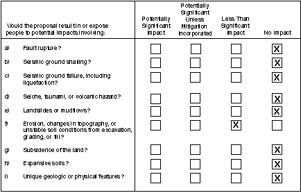
a) Fault Rupture
Construction envisioned for the project at each generation station includes only minor facilities to separate the new owner's generation facilities from the remaining Edison facilities, such as fencing. Any such minor construction activities would be required to follow appropriate design criteria for seismic loading and other geologic hazards as provided in the seismic elements of city and county general plans, which typically incorporate the design standards of the Uniform Building Code. These actions would not result in any change in the exposure of the public to geologic hazards.
Conclusion
No aspect of the project would alter seismic hazards at the respective plants. Therefore, the project would have no impacts related to fault rupture.
b) Seismic Ground Shaking
See response to checklist item 4.3a above.
Conclusion
Because the project involves a change of ownership of the plants, and no substantial construction is reasonably foreseeable as a consequence of the project, it would not affect the nature of ground shaking at any of the sites. Therefore, no impacts related to seismic groundshaking would occur.
c) Seismic Ground Failure
See response to checklist item 4.3a above.
Conclusion
The project would not alter the hazards of ground failure resulting from seismic events. Any construction activities would be required to meet current seismic design codes. Therefore, the project would have no impacts related to seismic ground failure.
d) Seiche, Tsunami, and Volcanic Hazards
The project would not involve any physical changes which could affect hazards related to seiche, tsunami, or volcanic eruptions and would not expose people to these hazards.
Conclusion
The project would not result in any physical modifications that would expose people to seiche, tsunami, or volcanic hazards. Therefore, the project would have no impact in these areas.
e) Landslides and Mudflows
The project would not involve any physical changes that would substantially increase the potential for landslides and mudflows.
Conclusion
The project would not result in any physical modifications that would expose people to landslides and mudflows. Therefore, the project would have no impact.
f) Erosion
The potential construction activities associated with the project (e.g. fences) would involve disruption of soils and could increase the potential for soil erosion. Soil remediation activities that may be a part of the ownership transition could result in the contact of stockpiled contaminated soil to runoff and wind. As described in Section 4.9, (d) Hazards, soil remediation activities are subject to oversight by the respective local agency and/or the California Department of Toxic Substance Control. Worker safety related to remediation activities is promoted by Federal and State OSHA regulations. Permits may need to be obtained prior to any remediation work, and a remediation plan is usually prepared before such work begins. Remediation plans, and sometimes permits themselves, require that specified precautions be taken during remediation in order to protect human health and environment. This oversight typically includes means to control erosion of stockpiled materials. Examples of procedural and operational controls that typically are implemented during remediation activities include covering soil stockpiles to prevent erosion and reduce infiltration, installation of a leachate control system to capture any leachate generated, construction of a containment cell to prevent runoff, installing treatment systems for treating groundwater, surface water, or air containing hazardous substances, collecting and analyzing test samples, watering disturbed areas to reduce dust generation, and wearing proper personal protective equipment to prevent worker contact with contaminated soil or groundwater. Many of these controls are contained in permits requirements that are issued by the regulatory agencies overseeing remediation activities. Whatever entities own these plants, Edison or any future purchaser, they would be subject to the same environmental and worker safety laws, rules, and regulations. The plants, under whatever ownership, would be expected to conform to all pertinent environmental and safety requirements.
The minor construction activities anticipated for the project, such as construction of fences, would involve minor disruptions of soils which may result in minor amounts of erosion. If these activities disturb over 5 acres of land, a NPDES Stormwater Pollution Prevention Plan, which would include erosion control measures, will be required by the appropriate Regional Water Quality Control Board. Erosion from projects less than 5 acres would normally not be significant.
Conclusion
The project would not result in significant impacts on erosion.
g) Subsidence of the Land
The project would not involve any physical changes related to land subsidence or that would contribute to land subsidence.
Conclusion
The project would not result in any physical modifications that would expose people to land subsidence. Therefore, no impact would be expected.
h) Expansive Soils
If new owners wish to modify the plants, developed entitlements and associated environmental review would be required. Assuming that appropriate engineering, design and construction practices are adhered to, as would be expected, impacts from expansive soil conditions would be less than significant.
Conclusion
No substantial construction or earthmoving activities are reasonably foreseen as a result of the project. Should any minimal construction be undertaken as part of the project, it would be conducted with the use of standard construction practices. Thus, the impact of expansive soils would be less than significant.
i) Unique Geologic or Physical Features
No unique geologic or physical features or mineral resources are known at this time that would be affected by the project.
Conclusion
The project would not result in any physical modifications that would affect any unique geologic or physical features or mineral resources. Therefore, the project would have no impact.