


PG&E Richmond-to-Pittsburg Pipeline
Section 2-V Cultural Resources
Previous Section | Next Section
SETTING
Numerous studies have shown that there is significant archaeological evidence that Contra Costa County has been inhabited for at least the last 5,000 years. Three Native American groups have been identified as inhabiting the area prior to initial European contact, including the Costanoans, Bay Miwoks, and the Northern Valley Yokuts. At the time of European contact, each tribe occupied the western, eastern, and southern portions of the county, respectively. Prehistoric remains are abundant with over 600 archaeological sites countywide having been recorded with the Archaeological Inventory (Pacific Gas and Electric, 2000). The pipeline alignment and associated structures travels through coastlines, wetlands, and stream courses, all of which are generally the most likely areas to contain archaeological sites. The most likely sites anticipated to reside within the pipeline route would consist of shell mounds or middens, sweat houses, cultural utensils, and hunting equipment (Pacific Gas and Electric, 2000).
A majority of the pipeline alignment traverses through urbanized areas, which have been previously disturbed by the construction of railroad tracks, spurs, underground pipelines, and a variety of other urban-related construction activities, such as grading, filling, etc. Previous construction of the existing railroad and utility lines presumably disturbed many prehistoric sites, since these sites are often located near major travel routes, such as the Union Pacific Railroad corridor.
ARCHAEOLOGICAL RESOURCES
Site records and literature searches were performed at the Northwest Information Center (Sonoma State University). These searches included a review of the National Register of Historic Places (NRHP) listings, the State of California Historic Landmarks registers and county and city registers for historic sites. Results of the listed historic and prehistoric archaeological sites are indicated below for the pipeline alignment. Portions of the alignment were previously surveyed during the pipeline's initial construction. Reconnaissance surveys were conducted in areas where native soils were present, where the built environment did not completely mask the ground surface, and at locations where records indicated were not previously surveyed. Because most of the alignment would be located in along the UPRR grounds visibility during field surveys was frequently severely inhibited.
Native American consultation for this project is an ongoing process. Letters have been sent to the Native American Heritage Commission (NAHC) requesting a search of their Sacred Lands files. Protocols for Native American consultation and involvement will comply with the standard procedures requested by the NAHC and with the recommendations discussed at the February 4, 2000, meeting of NAHC (i.e., continuous consultation with the affected groups and sincere consideration of Native American concerns regarding prehistoric sites and resources). It is assumed that Native Americans will serve as consultants and will be a part of the monitoring team in those areas containing resources that are important to local Native American people. Contact letters have been sent to the Native Americans recommended by NAHC to be contacted for this project.
City of Richmond
Remains from the prehistoric Costanoan culture are found in a number of archaeological sites that tend to be clustered along creeks, marshlands, and bayside coves. Artifacts located along the pipeline route within the city of Richmond include a minor shell midden site that was recorded near San Pablo Creek during pipeline construction. However, due to previous disturbance and lack of additional artifacts, no mitigation was recommended. The pipeline also crosses Wildcat Creek and Rheem Creek, however areas within Richmond that are typically considered archaeologically sensitive tend to be located along San Pablo Bay, west of the pipeline (City of Richmond, 1994).
By 1850, the Richmond area had changed from being a gathering center for prehistoric Native Americans to a European settlement. The oldest historical areas in the city are located in Point Richmond, which is south of the pipeline. Point Richmond began as the westernmost terminus of the Santa Fe Railway Company. Other industries later included oil and brick production, and wine exporting. Six sites are listed in the National Register of Historic Places, none of which are near the existing pipeline alignment.
City of Pinole
Mainly Spanish settlers displaced the Costanoan populations in the City of Pinole by the early 1800s (City of Pinole. 1995). Now the area is largely developed and according to the Contra Costa County General Plan, no sensitive prehistoric resource areas are listed as residing in the area. In addition, no prehistoric sites were reported in this area during original archaeological investigations for the pipeline (Pacific Gas and Electric, 2000). However, the route does follow the shoreline and crosses Pinole Creek, which allows for the possibility of finding subsurface prehistoric deposits if ground-disturbing activities are conducted in the area.
The City of Pinole was established around an early trading facility that was founded by a Portuguese immigrant on the shore of San Pablo Bay, known as the Fernandez Mansion (City of Pinole. 2000). This historic landmark still exists today and is located at the end of Tennent Avenue, which is just south of the pipeline and Union Pacific Railroad.
City of Hercules
Similar to Pinole, the land area encompassing the City of Hercules was inhabited by the Costanoans prior to European contact (City of Hercules. 1998). The pipeline follows the shoreline and crosses Refugio Creek, where prehistoric deposits could potentially reside; however no sites were discovered during the initial construction of the pipeline.
In 1881, the California Powder Works started operation in Hercules, originally producing black powder for dynamite and then other explosive substances during World War II. The historical district known as "Hercules Village" is located just to the south of the pipeline at Railroad Avenue (City of Hercules. 1998).
The Hercules Pump Station is located off San Pablo Avenue in the northeastern section of the City of Hercules. The site is situated on a hilltop on the eastern side of Refugio Valley. Refugio Creek winds through the valley to the west. The station would appear to be a typical location for prehistoric cultural resource sites, but none were reported from surveys and research associated with the initial construction of the pump station (Pacific Gas and Electric, 2000).
City of Martinez
Martinez is located at the base of the rolling hills to the south along the banks of the Carquinez Straits, near the mouth of Alhambra Creek, which once flowed into a ecologically diverse estuary. Native Americans tribes most likely took advantage of the location. An archaeological survey was performed along the northwest end of town near the old town cemetery when the pipeline was initially installed, however, no evidence of any archaeological site was found. It is assumed that there is low potential for Native American sites along the pipeline corridor in this area, due to it being inundated during historical time (City of Martinez. 1995). A few sites have been recorded on the backslopes of the hills to the south.
The city was originally utilized as a trading post in 1849, and by the turn of the century, abundant activity was occurring in the vicinity of the pipeline route, including railroad construction and the development of a fishing and shipping port. John Muir established a home in Martinez, which has been designated a national historic site. Four other sites are listed with the National Register of Historic Places, but none are located within a close proximity to the pipeline alignment (Northwest Information Center, 2000).
4,000-Foot Replacement Section
The immediate vicinity surrounding the 4,000-foot replacement section was examined in more detail, due to the potential for ground disturbing activities during the pipeline's replacement. A field inventory performed by Basin Research Associates found no evidence of significant historic or prehistoric archaeological resources within the existing pipeline alignment, which has been disturbed by railroad tracks and prior construction activities. The cultural resource investigation did not cover the northern end of the pipeline replacement section, which extends approximately 300 feet north of the study area to the Martinez Regional Shoreline Park. This portion of the replacement section is largely developed with paved roadways and commercial facilities, thereby making it highly unlikely that any intact cultural deposits would be encountered. Native American sites are unlikely north of the railroad tracks because the area was an inundated marshland in prehistoric times. The central portion (Alhambra Avenue to Ferry Street) of the replacement section was previously investigated for the Martinez Intermodal Station project and no cultural resources were identified within the area of potential effect (City of Martinez. 1994).
A record search was performed for this portion of the pipeline. No local, state, or federal historically or architecturally significant structures, landmarks, or points of interest have been identified within or adjacent to the existing pipeline right-of-way (Northwest Information Center, 2000). Two historic resources were reported within 0.25 mile of Grangers' Wharf and the Southern Pacific Railroad Depot, but they are not within a close proximity of the proposed pipeline replacement section (Northwest Information Center, 2000).
City of Pittsburg
The section of pipeline evaluated ends at the western end of the City of Pittsburg, which is recognized as one of the earliest industrial centers in Contra Costa County. Coal, steel, and canning are some of the industries that contributed to the city's early development. A historical district is located at the core of downtown Pittsburg, known as the New York Landing (City of Pittsburg. 1988). The district is located over a half mile east of the pipeline ending point.
UNINCORPORATED AREAS OF CONTRA COSTA COUNTY
Point Pinole Regional Shoreline Park
This area consists of sections of shoreline between Richmond and Pinole. It represents a potential location for prehistoric sites, due to the intact shoreline. An archaeological site located 0.5 mile west of Pinole at the water's edge was investigated during installation of the pipeline (Pacific Gas and Electric, 2000). The location was recently disturbed by machinery and no archaeological materials were discovered.
El Sobrante
Also located between Richmond and Pinole, El Sobrante is listed as particularly sensitive in the Contra Costa County General Plan with known archaeological sites. It is a likely place to find sites, though they may not be visible on the ground surface.
San Pablo Bay Regional Shoreline Park
This shoreline area is located along the southern end of San Pablo Bay within the cities of Pinole and Hercules. The easternmost section is near the Hercules Village historic landmark described above under the City of Hercules. No prehistoric sites were discovered during pipeline installation, and it is not considered to be a particularly sensitive cultural resource area according to the County Archaeological Sensitivity Map (Pacific Gas and Electric, 2000 and Contra Costa County. 1996).
Rodeo/Crockett
The unincorporated towns of Rodeo and Crockett are situated at the mouth of the Carquinez Strait, approximately 3-miles east of Hercules. Two archaeological sites were investigated during initial pipeline installation. One site was located at Lone Tree Point in Rodeo, near the mouth of Rodeo Creek. A remnant of the site was found on the northern side of the railroad tracks, however, no remains were visible on the inland side where the pipeline route is located (Pacific Gas and Electric, 2000). Construction of the railroad and pre-existing utility lines most likely destroyed a portion of the site. The other archaeological site was located in the town of Crockett, east of the Carquinez Bridge. For the most part, this site was buried by the freeway interchange and industrial complex that occupies the area, though a trace of a shell midden was found well outside the pipeline route (Pacific Gas and Electric, 2000).
The only paleontological deposits described as near the pipeline in the original investigations were also located on the shore, south of Lone Tree Point (Pacific Gas and Electric, 2000). These deposits were not disturbed by installation of the pipeline and are considered to be intact. The area along the coast west of Interstate 80, all the way to the Tosco Corporation property is listed in the Contra Costa County General Plan as extremely sensitive, with known archaeological sites (Contra Costa County Planning Department. 1989).
Carquinez Strait Regional Shoreline Park
The Carquinez Strait Regional Shoreline Park encompasses approximately 2,795 acres of bluffs and shoreline between Crockett and the City of Martinez. One prehistoric site record was investigated during the initial pipeline installation, and is located just east of a T-shaped dock approximately one-mile west of Martinez (Pacific Gas and Electric, 2000). This area is described as highly sensitive, with known archaeological sites. No evidence of the site was found, however, it was suspected that the site is actually located somewhat inland along an intermittent stream. The western portion of the park is not considered as sensitive; however, there is a possibility of cultural resources existing in the area, due to the lack of urbanization. At the northwestern edge of the Shoreline Park lie remnants of former brickworks, a grain wharf, and a resort, which all date back to the turn of the century (Contra Costa County, 1996).
Port Costa
The existing pipeline alignment traverses the shoreline through this unincorporated town and county lands to the east. No sites were mentioned in the original pipeline cultural resource investigation, but it is considered as a highly sensitive area with known archaeological sites documented in the Contra Costa County General Plan. Port Costa is one of the oldest towns in Contra Costa County and in the mid-1850s it was the largest port in the world for the export of farm goods.
Avon
This area is largely urbanized, and includes an operating oil refinery and chemical production plant. The pipeline alignment crosses through Pacheco Creek/Slough and other altered waterbodies, however, this area is not considered a sensitive area, as development most likely has disturbed any archaeological sites.
Port Chicago/Nichols
The pipeline passes through the U.S. Naval Weapons Station (Port Chicago), approximately a half-mile inland from the shoreline. No sites were observed along the pipeline route during its initial installation. Military bases often have land that has remained undeveloped, therefore this area could potentially contain sites associated with the various waterways and wetlands in the area.
Bay Point
Bay Point is located to the east of the U.S. Naval Weapons Station. A majority of the area in which the pipeline passes through was noted as sensitive for prehistoric cultural resources in the City of Pittsburg General Plan. Considering the industrial history of Pittsburg, there is a high possibility of finding historical resources somewhere in the vicinity of the pipeline, however, the pipeline travels through mainly marshland up to the Pittsburg Power Plant. One historic site is situated near the north end of Broadway Avenue. Because there was no mention of it in the original investigations for the pipeline, there is a high probability that it is outside of the pipeline's area of environmental effect (Pacific Gas and Electric, 2000).
PALEONTOLOGICAL RESOURCES
Paleontologists consider all vertebrate fossils to be of significance. Fossils of other types are considered significant as well if they represent a new record, new species, an oldest occurring species, the most complete specimen of its kind, a rare species worldwide, or a species helpful in the dating of formations. However, even a previously designated low potential site may yield significant fossils. The Contra Costa County Planning Department has prepared a general sensitivity map for the County and that mapping was used for the current study.
Paleontological information was obtained from available geologic maps, a review of previous environmental studies, and examination of records at Sonoma State University. Other resources considered in the determination of paleontologic potential are regional geologic reports, and site-specific field surveys. Geologic maps (available through the U.S. Geological Survey [USGS] or California Division of Mines and Geology [CDMG]) show the surface expression of geologic formations along with other geologic features such as faults, folds, and landslides.
Geologic formations in which fossils are found range in thickness from a few feet to hundreds of thousands of feet. Even though a geologic formation may be known to contain fossils, the fossils are not usually distributed uniformly. If the fossils were part of a bay environment, for example, a scattered layer of shells may be preserved over large areas. If, on the other hand, a whale died in this bay, fossilized whalebones might only be found in one small area of less than a few hundred square feet. In addition, fossil-bearing formations are frequently discontinuous. Although sedimentary formations are initially deposited one atop the other, much like a layer cake, over time the layers are squeezed, tilted, folded, cut by faults and vertically and horizontally displaced, so that today, any one rock unit does not usually extend in a simple horizontal layer. In addition, because paleontological resources usually are deeply buried, their presence in an area is difficult to predict from surface inventories and existing geological maps. Even in cases where a fossil-bearing formation is found in a surface outcrop, the fossil-bearing unit may occur at the surface for only a short distance and from this evidence its depth or lateral extent would be difficult to predict. The following types of paleontological resources are known to exist in California:
- True Fossils. Lithified or replaced remains of plants and animals preserved in a rock matrix (e.g., microfossils, shells, animal bones and skeletons, and whole tree trunks);
- Trace Fossils. Molds, casts, tracks, trails and burrow impressions made in soft clays and muds which subsequently were turned to stone, preserving the images of past life (e.g., shells, footprints, leaf prints, and worm tubes);
- Breas. Seeps of natural petroleum that trapped extinct animals and preserved and fossilized their remains.
The only potential for the project to disturb paleontological resources is during construction of the replacement section in Martinez. The entire replacement section would be constructed on intertidal bay deposits. As indicated above, these types of geological formations are not conducive to the formation of true fossils, trace fossils, or breas.
REGULATORY SETTING
FEDERAL REGULATORY OVERSIGHT
Federal regulations and policies pertain to those actions that involve federal funding, federal licensing, or federal permitting. Examples may include federal grants or licensing (FERC and ICC) and federal permits associated with vegetation and wetlands (U.S. Army Corps of Engineers [Corps] Section 404 permits). If it is determined that the 4,000-foot pipeline replacement section will require a Preconstruction Notification to the U.S. Army Corps of Engineers, SPBPC would be required to obtain a Nationwide 12 permit. The need for this permit is not presently clear, as the replacement section may be routed along existing bridges, rather than bored under any wetlands.
Section 106 Review
Section 106 of the National Historic Preservation Act (NHPA), and its amendments effective June 1999, requires that all federal agencies review and evaluate how their actions or undertakings may affect historic properties. Review under Section 106 is designed to ensure that historic properties are considered throughout the various stages of federal project planning and execution. Under Section 106, historic properties are those prehistoric and historic resources that are listed or eligible for listing in the National Register of Historic Places. The review process is administered by the Advisory Council on Historic Preservation and the State Historic Preservation Officer (SHPO). Recent changes to the Section 106 process have somewhat increased the role and authority of the SHPO and reduced the role of the Advisory Council.
For actions specific to the proposed project, the Section 106 process may apply if there is a later requirement for a Corps Section 404 permit for river and stream crossings or other waterways under the Corps' jurisdiction.
STATE REGULATORY OVERSIGHT
With the CPUC as the lead agency, California policies and regulations are the primary source of regulations and guidelines for the project.
State Historical Building Code
In California, the State Historical Building Code (SHBC) provides some degree of flexibility to owners of historic structures towards meeting building code requirements. The SHBC standards and regulations are performance-oriented rather than prescriptive unlike most housing codes which are more prescriptive. Jurisdictions must use the SHBC when dealing with qualified historical buildings, structures, sites, or resources in permitting repairs, alterations and additions necessary for the preservation, rehabilitation, relocation, related reconstruction, change of use, or continued use of a historic property. The State Historical Building Safety Board has adopted the following definition for a qualified historical house or resource:
A qualified historical building or structure is any structure, collection of structures, and their associates sites, deemed of importance to the history, architecture or culture of an area by an appropriate local, state, or Federal governmental jurisdiction. This should include designated structures declared eligible or listed on official national, state, or local historic registers or official inventories such as the National Register of Historic Places, State Historic Landmarks, State Points of Historical Interest, and officially adopted city or county registers or inventories of historical or architecturally significant sites, places, or landmarks.
Under the provisions of the SHBC, new construction or modifications, such as placing a generating station or other fiber optic facility in a historic building must conform to prevailing codes, although the elements of the existing structure are given the flexibility of reasonable and sensitive alternatives. The alternative building standards and regulations encompassed by the SHBC are intended to facilitate the renovation in a manner that assists in the preservation of original or restored architectural elements and features, encourages energy conservation, provides a cost-effective approach to preservation, and ensures the safety of occupants.
Local Regulatory Oversight
The policies and regulations of the various counties as they apply to historical resources in the project area are limited. Each affected county has policies (ordinances and General Plans) that mimic CEQA and also reflect local policy on the preservation and enhancement of cultural resources.
Contra Costa County General Plan
The Contra Costa County General Plan (1996) addresses policies and procedures to mitigate impacts to prehistoric and historic cultural resources. These policies and procedures were intended to provide direction in the event of the discovery of archaeological resources during development or construction activities. The Contra Costa County General Plan outlines the following policies, which pertain to historic and archaeological resources located within the county:
Policy 9-28 - Areas which have identifiable and important archaeologic or historic significance shall be preserved for such uses, preferably in public ownership.
Policy 9-29 - Buildings or structures that have visual merit and historic value shall be protected.
Policy 9-30 - Development surrounding areas of historic significance shall have compatible and high quality design in order to protect and enhance the historic quality of the area.
Policy 9-31 - Within the Southeast County area, applicants for subdivision or for land use permits to allow non-residential uses shall provide information to the County on the nature and extent of the archaeological resources that exist in the area. The County Planning Agency shall be responsible for determining the balance between the multiple use of the land with the protection of resources (Contra Costa County, 1996).
City of Richmond
The City of Richmond General Plan contains a set of polices within the Conservation Element that provides guidance for the preservation of local historical and archaeological resources. Policies that would be applicable to the Proposed Project include:
Policy OSC-E.1 - Require archaeology reconnaissance surveys for all projects within an archaeological sensitivity area. When cultural resources are located, measures to deal with the historic resource shall be recommended by a qualified archaeologist (Archaeological Sensitivity areas are identified on the Archaeology map prepared by the California Archaeological consultant, 1981, and is on file in the Planning Department).
Policy OSC-E.2 - Protect notable historic, archaeological, and cultural sites from destruction (City of Richmond, 1994).
City of Hercules
The City of Hercules General Plan contains a set of polices related to the preservation of local historical and archaeological resources. Policies that would be applicable to the Proposed Project include:
Policy 12a - Prehistoric Resources shall be identified and preserved to the extent feasible. If previously unknown subsurface cultural resources are discovered during excavation activities on identified parcels or elsewhere in the study area, excavation would be temporally halted and an archaeologist consulted as to the importance of the resources. Should the archaeologist determine that the resources are important, the project sponsor would follow the procedures described in Program 12a.2, outlined in the Parks and Open Space Element of the General Plan (City of Hercules. 1998).
The City of Hercules Zoning Ordinance identifies an Historic Town District, which contains specific design standards for the district, however, after further evaluation, it has been determined that the pipeline alignment does not pass through this district.
East Bay Regional Park District
Shoreline Regional Park is within the East Bay Regional Park District. Ordinance 38 provides the regulatory framework used by the Regional Park District to govern park uses within each of the parks under its jurisdiction. Chapter VIII of Ordinance 38 outlines policies for the protection of Important Park Features. Section 806 of Chapter VIII pertains specifically to Archaeological Features within park boundaries. Section 806 specifically states that: "No person shall damage, injure, collect or remove any object of paleontological, archaeological or historical interest or value located on District parklands. In addition, any person who willfully alters, damages, or defaces any object of archaeological or historical interest or value or enters a fenced and posted archaeological or historical site shall be arrested or issued a citation pursuant to Penal Code Section 622-1/2."
City of Martinez
Chapter 22.47 of Title 22 of the City of Martinez Zoning Code pertains to the preservation of structures and districts, which significantly contribute to the cultural and architectural heritage of the City. The ordinance bestows the Martinez Planning Commission with the responsibility of preserving the architectural heritage of the City of Martinez. It gives the Commission the authority to conduct surveys of structures, maintain a register of cultural and historic resources, and adopt guidelines for the designation of such resources. The ordinance requires the Commission to adopt prescriptive standards to be used in reviewing applications for permits to alter, remove, or destroy historic or cultural resources, or contributing structure to a historic district. From available maps, the project alignment does not intersect with any local historic district and as indicated in the Basin and Associates Report, no historic structures reside within project alignment. Consequently, Chapter 22.47 of the City of Martinez Zoning Code would not apply to this project.
CULTURAL RESOURCE IMPACT DISCUSSION
The greatest impact to cultural resources and, more specifically, to archaeological and paleontological resources in the ground, would occur as a result of construction-related activities from trenching operations involved with the installation of pipeline along 4,000-foot replacement section in the city of Martinez and other ground-disturbing activities. Excavation into a significant resource could compromise the significance of an historic or archaeological site, disturb the integrity and context, unearth human remains, impair the scientific value of the resource, or otherwise damage non-renewable resources. However, ground-disturbing activities associated with placement of the pipeline would be linear and relatively narrow. As a result, only a narrow section of the alignment, approximately 10 to 20 feet, would be exposed to trenching activities.
The original cultural resource investigation conducted for the pipeline in 1974 concluded, "no archaeological values of significance would be affected by the proposed pipeline." Ground disturbance, however, can uncover buried sites that were not visible during the original investigation.
- The definition of "historical resource" includes archaeological resources listed in or formally determined eligible for listing in the California Register and, by reference, the National Register of Historic Places, California Historical Landmarks, Points of Historical Interest, and local registers (Sections 5020.1(j) and 5024.1 of the Public Resources Code). Two historic land grants were found within the vicinity of the pipeline alignment, the Rancho Las Juntas east of the Arroyo Del Hambre and the Rancho Canada Del Hambrey Las Bolsas to the west of the 4000-foot replacement section. The record research gave no indication of historical archaeological sites or historic structures in the project area dating back to these occupants.
Historic maps dating 1870 to 1883 indicate that areas to the east and west of the Martinez Intermodal Station are considered to be highly sensitive for both surface and buried historic cultural resources based on the abundance of activity historically, including construction of the railroad, nearby Grangers' Wharf, and land reclamation. However, most of the pipeline construction would be within areas previously disturbed by construction of the railroad and paved roads. The archaeological field inventory conducted by Basin Research Associates concluded that no evidence of prehistoric or historically significant archaeological resources was observed within the disturbed railroad rights-of-way and paved roadways adjacent to the railroad (Basin Research Associates, 2000).
As currently proposed, no standing historical resources (buildings or structures) will be directly affected by the proposed project.
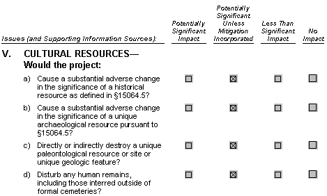
Impact V.1: Potentially undiscovered surface or subsurface historical resources could be damaged and/or destroyed by trenching activities proposed as part of the pipeline replacement. Therefore, the project could cause substantial adverse changes to the significance of historical resources. This is recognized as a potentially significant impact. However, this impact could be reduced to a less-than-significant with the incorporation of the following mitigation measures:
Mitigation Measure V.1a: SPBPC shall appoint a cultural resources specialist, or specialists, at least 15 days prior to the start of project-related vegetation clearance ground disturbance and grading, site or project mobilization, site preparation or excavation activities, implementation of erosion control measures, or movement or parking of heavy equipment or other vehicles onto or over unpaved or natural areas. SPBPC shall provide the CPUC mitigation monitor with the name(s) and statement of qualifications of its designated cultural resources specialist(s) who will be responsible for implementation of all project-related cultural resources mitigation measures. The statement of qualifications must be sufficient to substantiate that the specialist(s) meets the Secretary of the Interior's proposed Historic Preservation Qualification Standards as published in the Federal Register (United States Department of the Interior 1997).
At least 10 days prior to the start of any project-related activity defined above, SPBPC shall confirm in writing to the CPUC mitigation monitor that the approved designated cultural resources specialist will be available at the start of the project and is prepared to implement the mitigation measures. At least 10 days prior to the replacement of a designated cultural resources specialist, SPBPC shall obtain the CPUC mitigation monitor's approval of the proposed replacement cultural resources specialist.
Mitigation Measure V.1b: In the event that previously unidentified historic resources are encountered, the new owner (SPBPC) shall evaluate such resources for California Register of Historical Resources eligibility and conduct data recovery.
The cultural resources specialist shall ensure that the evaluations are supervised by individuals meeting the Secretary of the Interior's proposed Historic Preservation Qualification Standards (United States Department of the Interior 1997) for each particular resource type. An evaluation form shall be submitted to the CPUC mitigation monitor and the California Historical Resources Information Center.
For resources determined to be significant, the cultural resources specialist will prepare a resource-specific Data Recovery Plan to mitigate any significant project-related effects. Upon approval of this plan by the CPUC mitigation monitor, mitigation measures will be implemented prior to any project activities within 100 feet of the resource's boundary.
Mitigation Measure V.1c: Prior to the commencement of construction or ground distributing activities, all construction personnel will receive environmental training in a manner that would inform all personal of the possibility of encountering cultural or historical resources.
All construction personnel involved in activities that may uncover prehistoric resources will be trained in the identification of prehistoric resources, which could include flaked stone, projectile points, mortars, pestles, and soil containing shell and bone, or human burials. Historic resources could include stone or adobe foundations or walls, structures and remains with square nails, and refuse deposits. Construction personnel involved in activities that may uncover paleontological resources will also be trained in the identification of paleontological resources, which could include true fossils, trace fossils, and/or breas as defined under the above Paleontological Resources subsection. The level of training for construction activities should be sufficient such that the workers would know when to call their supervisors to investigate objects that may be a cultural resource. Supervisors would receive sufficient training to determine when a cultural resources specialist should be contacted to identify any found objects. If cultural resources were encountered during construction, the crew would halt work in the area and not collect or disturb the materials until the cultural resource specialist, appointed under Mitigation Measure V.1a, has evaluated the location and determined an appropriate mode of action.
- Section 21083.2 of the of the Public Resources Code defines an archaeological resource as a archaeological artifact, object, or site, which it can be clearly demonstrated that, without merely adding to the current body of knowledge, there is a high probability that it: (1) contains information needed to answer important scientific research questions and there is a demonstrable public interest in that information; (2) has a special and particular quality such as being the oldest of its type or the best available example of its type; or (3) is directly associated with a scientifically recognized important prehistoric or historic event or person. Appendix K of the CEQA Guidelines goes beyond Section 21083.2, suggesting additional criteria to guide the Lead Agency in making a determination of uniqueness. These include that the resource be at least 100 years old and possess "substantial stratigraphic integrity" (i.e., is substantially undisturbed); and the resource involves "important" research questions that historical research has shown can be answered only with archaeological methods.
According to the records research conducted by Sonoma State, two recorded archaeological sites, a lithic scatter and a bedrock milling site, are located on the slopes to the southwest of the project site, and a large habitation reported along the banks of the arroyo to the south in the vicinity of City Hall. However, based on historic reconstructions of the bay shore and marsh margins, the project area was inundated during prehistoric times. Given the environmental setting, there is a low potential for significant Native American sites in the project area. However, pedestrian surface survey as a method in identifying cultural resources is not effective when the original ground surface is not exposed, is obscured by vegetation, or has been covered by natural or cultural fill.
Impact V.2: Trenching or boring through these resources, if significant undiscovered resources were present, would cause an adverse change to their significance. Therefore, the project would have the potential to cause adverse changes to the significance of currently unknown unique archaeological resources. This is considered a potentially significant impact.
Mitigation measure: Implement Measures V.1a, V.1b, and V.1c.
Significance after mitigation: Less than significant.
- Impact V.3: Installation of the new pipeline segment along the 4,000-foot replacement section would involve shallow excavations primarily in pre-disturbed soils within the UPRR easement and city streets. Because significant fossil discoveries can be made even in areas designated as having low potential, excavation activities for the pipeline could possibly unearth significant paleontological resources contained within intertidal sedimentary deposits. While this in unlikely, should such resources be encountered, this would be a significant impact. This impact would be reduced to a less-than-significant level with the incorporation of the following mitigation measure:
Mitigation Measure V.2: SPBPC shall notify a qualified paleontologist of unanticipated discoveries, made by either the cultural resources monitor or construction personnel responding to their environmental training classes, as required in Mitigation Measures V.1a, V.1b, and V.1c, and document the discovery as needed. In the event of an unanticipated discovery of a breas, true, and/or trace fossil within the 4000-foot replacement section during construction, excavations within 50 feet of the find shall be temporarily halted or diverted until the discovery is examined by a qualified paleontologist. The paleontologist shall notify the appropriate agencies to determine procedures that would be followed before construction is allowed to resume at the location of the find.
Significance after mitigation: Less than significant.
- Impact V.4: Trenching, boring, or other subsurface excavation involved with the project could potentially disturb or destroy human remains from both prehistoric and historic time periods, including those interred outside of formal cemeteries. This considered a potentially significant impact. This impact would be reduced to a less-than-significant level with the incorporation of the following mitigation measures:
Mitigation Measure V.3: If human remains are found at any time along the entire pipeline alignment or during project-level vegetation clearance; ground disturbance and grading; site or project mobilization; site preparation or excavation activities; implementation of erosion control measures; or the movement and/or parking of heavy equipment or other vehicles onto or over the project surface, SPBPC and its contractors shall stop all work within 100 feet of the find (Debbie Treadway, 2001). The cultural resources specialist will be notified immediately and will, in turn, immediately notify the Contra Costa County coroner, in compliance with Section 7050.5 of the California Health and Safety Code. Upon the completion of compliance with all relevant sections of the California Health and Safety Code, the cultural resources specialist will implement Mitigation Measure V.1b.
If the human remains are determined to be Native American in origin, the Contra Costa County coroner will notify the Native American Heritage Commission within 24 hours of the find. The Native American Heritage Commission shall identify the person or persons it believes to be the most likely descendent of the deceased Native American. The most likely descendent may make recommendations to the SPBPC and its contractors for means of treating or disposing of, with appropriate dignity, the human remains and any associated grave goods as provided in Public Resources Code Section 5097.98. Where conditions A, B, and/or C under Section 15064.5 (e) (2) occur, the landowner or authorized representative shall rebury the Native American human remains and associated grave goods with appropriate dignity on the property in a location not subject to further subsurface disturbance.
Significance after mitigation: Less than significant.
REFERENCES
Basin Research Associates. 2000, Archaeological Resources Assessment - Pipeline Replacement Project North of the City Limits of the City of Martinez, Contra Costa County.
City of Hercules, 1998. City of Hercules General Plan.
City of Hercules, 2000. Online. http://www.ci.Hercules.ca.us/
City of Martinez, 1994. Martinez Intermodal Station Project Draft Environmental Impact Report.
City of Martinez, 1995. Martinez General Plan.
City of Pinole. 1995, City of Pinole General Plan.
City of Pinole. 2000. Online. http://www.ci.pinole.ca.us/info.html.
City of Pittsburg, 1988. Pittsburg General Plan.
City of Richmond, 1994. Richmond General Plan, Conservation Element
Contra Costa County, 1996. Contra Costa County General Plan 1995-2010.
Contra Costa County Planning Department, 1989. Historic Resources Inventory, Contra Costa County.
Debbie Treadway, 2001. California Native American Heritage Commission. Verbal Correspondence on June 21, 2001.
National Register of Historic Properties Database, 2000. Online. http://www.cr.nps.gov/nr/research/nris.htm.
Northwest Information Center, 2000, Cultural Resource Record Search for thePipeline along the Union Pacific Railroad in Martinez, Contra Costa County.
Pacific Gas and Electric Company, 2000. Proponents Environmental Assessment to Establish market Value for and Sell its Richmond-to-Pittsburg Fuel Oil Pipeline and Hercules Pump Station Pursuant to Public Utilities code Section 367 (B) and 851. Application Number 00-05-035.