

PG&E Land Transfers Final Mitigated Negative Declaration
Section 2-IX Land Use and Planning
Previous | Next Section
SETTING
The Shasta County General Plan and Zoning Ordinance guides land use and development on project lands located outside of FERCs jurisdiction. Any areas removed from the FERC project boundary will technically revert to Shasta County's, except lands transferred to the state DPR including the Burney Falls and Bowman Ditch lands. The Shasta County General Plan notes that the historic pattern of land use and the existing organization of its communities will largely determine the future pattern of land use development in Shasta County.
Land uses in the vicinity of the land transfer properties include open space, recreation, grazing, agriculture, timber, and residential and commercial development. Public lands in the area are managed by the Bureau of Land Management (BLM), U.S. Fish and Wildlife Service (USFWS), California State Lands Commission, California Department of Parks and Recreation (DPR), and the Bureau of Indian Affairs Office of American Indian Trust.
The Shasta County General Plan designates the transfer lands as follows:
Public Lands and Open Space
This designation provides for the protection of open space areas that generally do not have the resource values of agricultural or timberlands.
Full Time Agricultural Cropland
This designation provides for the protection of lands with soil characteristics, adequate size, and that can normally be irrigated for full time agricultural uses.
Timber
This designation provides for the protection of timberlands for timber management.
Zoning designations for the project lands include:
Limited Agriculture District (Five acre lot minimum)
This zoning provides for the preservation of agricultural lands at a size capable of supporting part-time agricultural operations.
Exclusive Agricultural District
This zoning provides for the preservation of lands with agricultural value that, has the combination of size and quality. The preservation of these lands is sometimes done in conjunction with other lands, to make their use for agriculture economically feasible, and within which agricultural preserves may be created for the purpose of utilizing provisions of the law relating to agricultural preserves.
Restrictive Flood District
This zoning is intended to be combined with any principal district to minimize or avoid hazards to life and property from flooding in the areas of special flood hazard established by the Federal Emergency Management Agency, pursuant to the Flood Disaster Protection Act of 1973, and in other areas of significant flood hazard.
Building Site District
This zoning is intended to be combined with any principal district to modify the minimum lot area standard otherwise applicable in the principal district.
Unclassified District
This zoning is intended to be applied as a holding district until a precise principal zone district has been adopted for the property. All new uses in this district shall be consistent with all applicable policies of the General Plan.
Burney Falls, Bowman Ditch, and Ahjumawi Property
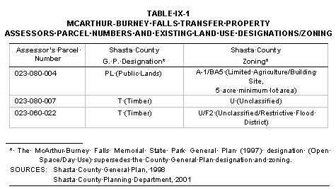
Existing Shasta County land use designations and zoning for the Burney Falls land transfer property are presented in Table IX-1.
The Burney Falls transfer property is irregular in shape and contains a total of about 182 acres. The site extends about two miles from east to west along the south shore of Lake Britton and up to about one-quarter mile south from the shoreline. The McArthur-Burney Falls Memorial State Park and State Highway 89 at the easterly extension bound the property on the south. Burney Falls is currently used for recreation. The property can readily be described as four separate areas, distinguished by differing physical characteristics and by differing uses. Each is described below:
- Burney Falls includes 49 acres area east of Burney Creek and extending north to include a broad peninsula, now used by the McArthur-Burney Falls Memorial State Park as a boat launching ramp and day use picnic area. Vegetation on this portion of the property is similar to that at the westerly end, but the conifer forest is slightly more open with a brush understory. Most of the area is fairly steep, but the peninsula is only slightly sloping to nearly level in a fairly large area. Access to this portion of the property is by way of a paved road that extends north from the McArthur-Burney Falls Memorial State Park campground a distance of about 1.5 miles.
- The portion of the property lying west of Burney Creek contains about 22 acres and includes mostly steep slopes along the lakeshore and a more level bench along the lake on the west side of the Burney Creek arm of the lake. This bench area is the site of Camp Britton. Vegetation on the slopes includes fairly dense stands of old growth mixed conifers up to about 30 inches or larger in diameter. The bench area where the improvements are located is more open, with annual and perennial grasses dominating the vegetative cover. Camp Britton is currently licensed by PG&E to Pacific Service Employees Association (PSEA), and has an eight-room, hotel style building, caretakers cabin, garage, shed, storage building, groundwater well, and dock. The residential building is constructed of wood walls with a shingle and sheet metal roof around a wood frame and is elevated off the ground by wood posts bolted to small concrete blocks. All other buildings are constructed of wood walls on concrete foundations with wood or shingle roofs. A groundwater pump house, located approximately 1,000 feet away from the camp, provides Camp Britton with potable water. The main building has about 6,048 square feet on the ground floor and 1,008 square feet on the second floor. The structure is divided into a total of eight separate units. These improvements are subject to the PSEA license agreement through 2005.
- The Cemetery Cove area of the Burney Falls property, also accessed through the McArthur-Burney Falls Memorial State Park, is named for a pioneer cemetery located there. This portion of the property contains about 34 acres, and the topography is more moderately sloping than the areas previously described.
- The easterly end of the property, bounded to the south by State Highway 89, includes a narrow projection along the lakeshore connecting to the Cemetery Cove area. This portion of the property is approximately 78 acres and has generally steep slopes with less dense conifer growth, but a heavier understory of brush. Access is directly off State Highway 89.
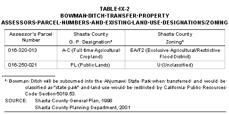
Existing Shasta County land use designations and zoning for the Bowman Ditch land transfer property are presented in Table IX-2.
The four-acre Bowman Ditch property, located near Eastman Lake and adjacent to the Little Tule River, was developed in the early 1940s to channel water flowing from various springs to the Little Tule River for hydroelectric power production. It remains functional and is currently inundated with water. Adjacent lands are unimproved grass and wetlands. A few farm buildings are visible near the upper end of Bowman Ditch, but these improvements are not located on the Bowman Ditch transfer property. Access to the property is by boat from the Little Tule River.
Existing Shasta County land use designations and zoning for the Ahjumawi land transfer property is presented in Table IX-3.
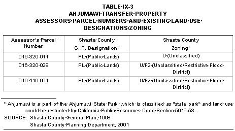
Ahjumawi is irregular in shape and contains a total of 544 acres. The Tule River bounds that property on the east and the Little Tule River on the west. The topography is nearly level to gently sloping at an elevation of about 3,300 feet. The property was protected from flooding by the State Park Levee, which followed the edge of both rivers a distance of about four miles around the boundary of the property. Because the levee failed in several locations in the early 1990s, the property is mostly inundated with water to a depth of several feet, and having had time to revert to natural conditions, would probably be classified as "wetlands".
McArthur Swamp and Glenburn Dredge Site
Existing Shasta County land use designations and zoning for the McArthur Swamp and Glenburn Dredge land transfer properties are presented in Table IX-4.
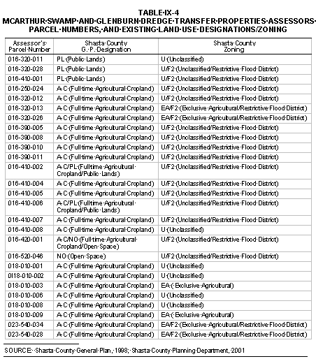
McArthur Swamp is 7,400 acres in size and includes significant reclaimed wetlands drained by canals and is protected by levees where the property meets Big Lake and the Tule River. These levees have historically been maintained and repaired either by dredging or importing fill material. The McArthur Canal extends from the Tule River between the confluence with the Little Tule River and Fall River, easterly and then southerly, exiting the property near the town of McArthur near the southeast corner of the property. The Lee Drain and the Central Drain enter the property along the east line and flows westerly, connecting with the McArthur Drain near the Rat Farm area.
Primary land uses on McArthur Swamp include livestock grazing, public recreation, and wildlife habitat management. While most of the property is devoted to livestock forage production, the Hollenbeak field and the Ash field are managed for wildlife habitat and public recreation facilities are provided at the Big Lake Access. The facilities include a car top boat launch, an adjacent parking area, and a toilet building. Big Lake Access serves as the primary access to the Ahjumawi State Park as well as boating access to Big Lake and Tule River. Other recreation activities occurring on McArthur Swamp include fishing, hunting, hiking, and wildlife viewing. The areas to the east and west of Big Lake Access are prime habitat for migrating waterfowl and other wildlife species. According to PG&E and its Application Number 00-05-029, these land uses have been managed concurrently for the past fifteen years without conflict (wildlife management compliments recreation and grazing is managed to protect wildlife habitat and recreation opportunities).
Livestock grazing is visibly the most dominant land use at McArthur Swamp. Over time, fencing, water, and field management plans have been developed to manage livestock through pastures to increase the productivity of McArthur Swamp. Generally, livestock are returned to McArthur Swamp in mid-April on the fields designated as S1 through S5 as well as El. As fields dry following the spring rains, livestock are gradually rotated into fields N1 through N4 and E2 and E3. During the summer and late summer periods, the livestock are moved into fields Al, A2 (Ash Field) and HB1 and HB2 (Hollenbeak). The locations of the fields are shown in Figure 1-6.
Each field is fenced and most have stock water tanks to provide water for the livestock, however many of the lowland areas in the Ash Field and Hollenbeak fields retain water through the summer and the livestock are generally not restricted from these areas. Roads and levees are fenced to prevent damage by the livestock. The livestock are removed no later than mid-November of each year.
The Dutra dredge "Frances" is normally berthed along side of the 5.5 acre Glenburn Dredge Site however the dredge is occasionally moved up and down stream as needed for minor levy repair work. Until recently, the California Wildlife Conservation Board (CWCB) in cooperation with PG&E and an adjacent landowner managed public access to the Fall River. A ten-car parking lot, car-top boat launch area, toilet and trash facilities were provided. The boat launch was an unimproved ramp that was simply a gradual access to the Fall River. There is no concrete or gravel ramp that would allow a vehicle to back to the water's edge. In 1996, public access to the boat launch site and parking area was terminated and the recreation site has not been maintained since that time. It is currently overgrown with weeds and grass, and the portable toilet and trash containers have been removed. The boat launching site is also overgrown with tules. A locked gate at the entrance prevents public vehicle access.
LAND USE AND PLANNING IMPACTS AND DISCUSSION
Burney Falls, Bowman Ditch, Ahjumawi Property, McArthur Swamp, and Glenburn Dredge Site
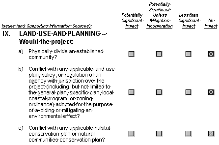
- The land transfer properties are located near, but not within, established communities, such as McArthur, Burney, and Fall River Mills. Therefore, the land transfers will not divide an established community or create an impact.
Burney Falls, Bowman Ditch, and Ahjumawi Property
Burney Falls
- DPR proposes to operate Burney Falls consistent with the McArthur-Burney Falls Memorial State Park General Plan and the restrictions of the Pit 3, 4 and 5 Project License (FERC No. 233). Any changes that may occur at Burney Falls will occur regardless of whether the proposed transfer is approved; DPR does not need to obtain the fee interest to carry out its General Plan. In addition, more than one-half of Burney Falls will remain subject to the FERC license regardless of whether or not DPR possesses the fee interest in Burney Falls. The project would not result in any conflicts with adopted land use plans, therefore there is no potential impact.
Bowman Ditch
- When Bowman Ditch is transferred to DPR, it will become a part of the Ahjumawi State Park. Since a state park General Plan has not been prepared for Ahjumawi, land uses on the property are restricted by California Public Resources Code Section 5019.53, which restricts improvements to the purpose of making areas available for public enjoyment and education while preserving the natural, scenic, cultural and ecological values of state park lands. The Exchange Agreement does give DPR the right to "fill or otherwise alter Bowman Ditch as may be necessary to restore wetlands, [as long as DPR does not] divert water from its eventual flow into the Little Tule River." The land transfer will not result in a conflict with any applicable land use plan, policy or regulation of a jurisdictional agency, therefore no impact is expected.
Ahjumawi Property
- Under the proposed transfer agreement, the CWA will become the ultimate owner of the Ahjumawi property. Since no General Plan has been prepared for the park, land uses on the property would be restricted by California Public Resources Code Section 5019.53, which restricts improvements to the purpose of making areas available for public enjoyment and education while preserving the natural, scenic, cultural and ecological values of state park lands. Ahjumawi will also become subject to the Conservation Easement and the MSMP, which will further serve to preserve the land in its natural state. Therefore no significant adverse affect to land use is expected to occur as result of the property transfers.
McArthur Swamp and Glenburn Dredge Site
- The Shasta County General Plan provides overall land use policy guidance to McArthur Swamp and the Glenburn Dredge Site. In addition, a portion of McArthur Swamp is within FERC project boundaries for the Pit 1 Project (FERC No. 2687). FERC generally requires the consent and support of state and federal agencies interested in protecting the environment and preserving recreational uses for any activities occurring on these lands. Shasta County General Plan designations and zoning provide for the protection of open space areas and lands with agricultural value.
McArthur Swamp has historically been used for livestock grazing, recreation and wildlife habitat. The Conservation Easement and MSMP are intended to ensure that these pre-existing uses cannot be expanded in a manner that would create incompatibility between these uses. There are no incompatibilities or significant environmental impacts caused by the proposed changes to pre-existing land uses. Proposed changes proposed under the Conservation Easement and MSMP are geared toward the development and protection of nesting habitats, reverse cycle and fresh emergent wetlands, and other natural conditions, which could be viewed as beneficial to the environment.
The Glenburn Dredge Site will be transferred to CWA subject to conditions of the MSMP and the Transfer Agreement. The change in ownership will reopen the Glenburn Dredge Site to the public. However, it is not expected that the types of use or the intensity of the activities conducted on the lands will change substantially as a result of the land transfer. The conservation easement and MSMP will act as the equivalent of an area plan, providing defined land use planning guidance specific to the subject parcels. Because of the structured nature of the transfer and subsequent land management activities, the land transfers will not conflict with any land use plan, policy or regulation of the agencies with jurisdiction over the lands.
Burney Falls, Bowman Ditch, Ahjumawi Property, McArthur Swamp and Glenburn Dredge Site
- No natural communities conservation plans currently exist for northern California. There are no habitat conservation plans for the McArthur-Burney Falls Memorial State Park, the Ahjumawi Lava Springs State Park, or plans in Shasta County that would be applicable to any of the proposed transfer properties (Campbell, 2001). Therefore, the project does not have the potential to conflict with any plans, resulting in a finding of no impact.
REFERENCES
- California Codes. Public Resources Code 5019.53.
- Campbell, 2001. Vicki Campbell, United States Fish and Wildlife Service.
- Personal communication, May 26, 2001.
- PG&E, 2000. Proponents Environmental Assessment. Pacific Gas and
- Electric Company. Application No. 00-05-029, October 23, 2000. Application No. 00-05-030, October 23, 2000.
- Shasta County General Plan, October 1998. Shasta County General Plan,
- adopted by Resolution No. 5997, Board of Supervisors January 10, 1984, as amended through October 1995, reprinted November 1996, as amended October 1998.
- Shasta County Planning Department. General Plan Designations and
- Zoning information for the land transfer properties. Written correspondence. February 16, 2001.
- State of California, Resources Agency, Department of Parks and Recreation
- Commission. McArthur-Burney Falls Memorial State Park General Plan. June 1997.