


PG&E Land Transfers
Section 2-I Aesthetics
Previous Section | Next Section
SETTING
The Lake Britton property is highly valued as a scenic resource, as is much of the surrounding property administered by DPR and by the US Forest Service (Shasta National Forest). The PG&E property along the south shore of the lake offers important scenic views of Lake Britton and of the mountains and forest beyond the lake. Similarly, the property itself is part of scenic vista viewed by boaters in the lake, and hikers and campers on the north shore of the lake. The Pacific Crest National Scenic Trail runs along the south shore immediately to the west of the PG&E property before climbing around Burney Falls to the south of the lake. Lake Britton, including the PG&E property, is visible from many portions of the trail. Also running through the PG&E property is State Highway 89, running north and south across the lake at about its midpoint, before turning sharply to the west towards Burney Falls. Highway 89 across Lake Britton is designated as a scenic route on most highway maps, but is classified only as "Eligible State Highway Not Officially Designated" by the California Department of Transportation.
The Ahjumawi Property, like McArthur Swamp discussed below, is a relatively low-quality scenic resource. The Ahjumawi property is surrounded on three sides by levees that have fallen into general disrepair, causing repeated flooding of the property that DPR desires to transfer to PG&E. Access to the Ahjumawi Lava Springs State Park is by boat only across Big Lake, with the vast majority of visitors accessing the lake at a PG&E-maintained boat launch on the south shore of the lake at the end of Rat Farm Road. Because of the extensive flooding, the lack of access roads or trails, and the relative distance to the main features of the State Park, the property that DPR desires to transfer to PG&E is seldom if ever seen by visitors to the park. The area is not viewable from any highway, and only visible in the distance from one trail that runs to the north and west of the property. The trail is a former access road that has no official designation. The Ahjumawi Property would be subject to a Conservation Easement that would govern the McArthur Swamp area, as described below.
AESTHETICS IMPACT DISCUSSION
The lands in question are currently administered by PG&E under the restrictions of its FERC licenses for the Pit hydroelectric projects, or by DPR under the General Plan for the McArthur-Burney Falls Memorial State Park. DPR has not prepared a GP for Ahjumawi Lava Beds State Park, but the general provisions pertaining to lands classified as "state park" restrict its use. Because the Conservation Easements and adaptive management plan that govern the targeted lands subject to these applications would remain in effect and would specify various improvements to return the lands to a more natural state, the project would likely have an overall beneficial effect on aesthetic resources in the region. The extent to which those improvements are accomplished, and the quality of the work done, would largely depend on the resources that are brought to bear to accomplish the goals of the improvement plans. Therefore, the analysis of the potential impact to aesthetic resources largely hinges on the ability of the various organizations involved to secure the monetary and human resources needed to carry out the provisions of the management plans that will govern the areas involved. Because the organizations involved are well established and apparently well funded, it is reasonable to assume that they will carry out the requirements of the applicable management plans. Therefore, the project is not likely to create significant impacts to aesthetic resources.
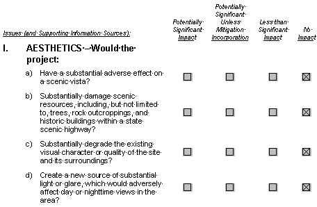
- Because the lands subject to the transfers proposed in the two applications would generally be returned to a more natural state, the project is not likely to have a substantial adverse effect on a scenic vista.
- There are no officially designated state scenic highways in the project area, therefore the project is not likely to create substantial (or even any) damage to scenic resources, including trees, rock outcroppings, and historic buildings within a state scenic highway.
- Because it generally calls for making improvements that would restore the lands subject to these applications, the project likely would not substantially degrade the existing visual character or quality of the site and its surroundings.
- The project does not involve construction of any new facilities or buildings, and therefore would not create a new source of substantial light or glare which would adversely affect day or nighttime views in the area.
REFERENCES
- California Department of Transportation web site on State official scenic
- highways: http://www.dot.ca.gov/hq/LandArch/scenic_highways/ index.htm
ESA site visit, January 2001.