


PG&E Land Transfers Final Mitigated Negative Declaration
Section 2-V Cultural Resources
Previous | Next Section
SETTING
This section characterizes the archaeological, ethnographic, and historical setting for the proposed transfer properties, along with the regulatory framework applicable to cultural resources for the properties involved in the proposed land transfers for Burney Falls, Ahjumawi Lava Beds State Park, and McArthur Swamp. Previous archaeological surveys and recorded sites within the transfer properties are discussed. The section concludes with a discussion of the potential impacts to cultural resources that could occur as a result of project-related actions and suggested mitigation measures to alleviate such impacts.
Ethnographic and Archaeological Background
All of the parcels involved in the proposed land transfers lie within the ethnographic territory of the Ahjumawi, who are more commonly referred to as the Pit River Indians. Several references discuss the culture and lifeways of these people (Dixon 1908, Kniffen 1928, Kroeber 1925, Merriam 1926, and Olmsted and Stewart 1978), and the following is summarized from these sources and from recent archaeological reports. Achumawi translates to "river (literally "it flows") people." The Achumawi occupied lands extending from Mount Shasta on the northwest to Lassen Peak on the southwest and from Goose Lake on the northeast to Eagle Lake on the southeast.
There are nine Achumawi tribelets, each of which occupied a portion of the Pit River and its tributaries, as well as lands extending some distance away from the river. The nine tribelets functioned as self-governing units, but were closely related through intermarriage. They shared a common language from the Palaihnihan branch of the Hokan family of languages, and although there were some dialectal differences, they were not different enough to prohibit communication. The proposed land transfers for this project includes lands in the traditional territory of three of these tribelets: Ahjumawi, Ilmawi, and Itsatawi.
Villages were centered around concentrations of food resources, such as fish streams and swamps. Structures used for habitation consisted of semi-subterranean winter structures with sloping bark roofs, and summer huts of brush or tule-mat. The winter village communities also contained a larger semi-subterranean structure used for gatherings.
The natural environment was rich with food resources, including fish, waterfowl, game, root crops, acorns, and other plants. Acorn processing was a staple of the indigenous subsistence patterns, and this resource was abundant along the Pit River. Streams, lakes, meadows, and swamps were especially important to the Achumawi because they provided such a large proportion of their food and shelter. Prior to the construction of powerhouses on the Pit River, salmon and other anadromous fish traveled up the Pit River and its tributaries. In Achumawi territory, there were about fifty miles of salmon streams and 150 miles of streams from which bass, catfish, lamprey, pike, suckers, trout, and a number of species of minnows were taken. Crawfish and mussels were also eaten. Vegetal foods were an important part of the diet, and a wide variety of roots, seeds, berries, nuts, and herbs were gathered in season. Hunting appears to have been secondary to fishing and gathering, but numerous species were taken.
Archaeological investigations in the project vicinity have provided a chronology for the occupation by prehistoric people in the area. One of the earliest archaeological investigations in the project vicinity was conducted by Baumhoff and Olmsted (1963) at the Lorenzen site in Little Hot Springs Valley, Modoc County; and more recent work has been conducted by Manuel (1983), by Kelly et al. (1987), and by Hull et al. (1999). The project areas appear to have first been inhabited by ancestors of the Pit River Tribe approximately 5,000 years ago, and there has been almost continuous occupation since that time. This chronology has been divided into seven phases, with the most recent being the historic phase (A.D. 1730-1850) which ended with Euroamerican contact. Between 3000 B.C. and 1350 B.C., the region appears to have been used intermittently, with hunting as the main subsistence activity; and hunting continued to be the major subsistence focus between 1350 B.C. and A.D. 750. The Elko projectile point is the most common type noted in the archaeological record during this period; and obsidian sourcing studies document obsidian from nine major sources within a 50-mile radius of Lake Britton. These sites around the lake continue to yield valuable data on prehistoric economies and subsistence patterns along the Pit River.
A change in the subsistence base and technology appears to have occurred around A.D. 750 when the focus changed to riverine resources. Rosegate and Gunther style projectile points represent the period between A.D. 750 and A.D. 1450. Between A.D. 1450 and A.D. 1830, the population appears to have stabilized with subsistence still riverine-based; and Gunther and Desert Side-notched projectile point styles then dominate the cultural assemblages.
Historical Background
The first Euroamericans in the project area came in 1832-33 with a Hudsons Bay Company expedition led by John Work. The local natives shot and killed many of Works horses; and, thus, the Pit River peoples gained a reputation for being aggressive (Kelly et al. 1987).
Permanent settlement by Euroamericans began in the area some 20 years later; and through the 1860s, confrontation was common among the Pit River bands and Euroamericans, as the local natives resisted Euroamerican settlement of the area. This violence exploded in 1856 with the destruction of the small settlement and ferry at Lockhart Ferry, near the present town of Fall River Mills, east of Burney Valley. A retaliation effort in 1857 resulted in the killing of many Achumawi (Neasham 1957); and in 1859, a similar conflict took place between Euroamericans and the Atsugewi at Hat Creek Station (Garth 1978). Following the incident at Lockhart Ferry, George Crook, at the command of the U.S. 4th Infantry, Company D, built a fort in 1857 near Fall River Mills to establish a military presence in the area. Fort Crook was occupied until 1869 and played a major role in attracting new settlement to the region (Neasham 1957). A wagon road was built from Fort Crook to Redding (now submerged under Lake Britton); and communities developed in the area.
Glenburn is reportedly the first town in Fall River Valley. Originally called Burgettville, it was established in the 1860s by William Burgett, who, upon learning that it was illegal to sell liquor within a mile of a military post, paced off a distance of approximately two miles from Fort Crook and built his store and blacksmith shop (Smith 1991).
By the 1860s and 1870s, substantial Euroamerican settlement had occurred, and the violence between the groups had diminished, partly because indigenous populations had perished or had been moved to a reservation. Foreign-born disease was responsible, in part, for the devastation of local Native American populations; and in 1859, the State of California had moved the remaining Native Americans in the area to the Round Valley Reservation in Mendocino County. Later, however, the Achumawi and Atsugewi began leaving the reservation to return to their homeland (Garth 1978).
Burney Falls
Burney, Burney Valley, and Burney Falls were named after Samuel Burney who died at the hands of local Indians in 1858. In 1877, the Ray family moved into the woodlands near Burney Falls. The family developed this land near the falls, and they farmed and grazed cattle. A water-powered sawmill, an irrigation ditch, and numerous outbuildings were constructed. In 1906, Issac Ray left the area, selling his 160-acre farm, which included the Falls, to Judge J. W. Logan of San Francisco, a land speculator.
In the second decade of the twentieth century, hydroelectric power became an economic factor along the Pit River. Above the mouth of Fall River, the Pit River was a minor stream with little force; but below that point, with the added volume of Hat Creek, the Pit River became a major watercourse as it flowed toward its confluence with the Sacramento River. Mt. Shasta Water and Power Company and Pacific Gas & Electric Company (PG&E) began to buy property along the Pit River to create lake storage behind proposed power-generating dams. In the Fall River Valley, PG&E acquired water rights from the McArthur brothers and other valley ranchers. Reacting before the fact, Frank McArthur, a rancher from Likely Valley in Modoc County, convinced his brother Scott, a Fall River rancher, to buy the Logan property that contained the Falls, because the McArthurs feared that PG&E planned to dam and divert Burney Creek above the Falls. Scott purchased the 160 acres around the Falls and transferred it to Frank and Ethel McArthur. The McArthurs then gifted the property to the State of California for one dollar in May 1920. In 1922, the State of California transferred the property to the Division of Forestry to manage; and in 1925, under pressure from the McArthur family, the Division of Forestry assigned a custodian to manage the property as a public facility and gave it a name, McArthur Memorial Park.
Meanwhile, PG&E was building the dam below the confluence of Burney Creek and the Pit River that would create Lake Britton. The company declared a piece of property surplus just to the north of the original park, and this additional 160 acres was gift-deeded to the Division of Forestry, making McArthur Memorial Park a 320-acre park. The park then went to the State Park System shortly after its creation in 1926 (Department of Parks and Recreation 1997).
McArthur Swamp
The McArthur Swamp exemplifies mid-nineteenth and early twentieth century Euroamerican settlement patterns in the region. In 1860, settlers purchased nearby lands from the state of California and performed the first reclamation in the area by blasting out a section of rock to drain Big Lake. Much of the lake was drained, but the swamp area remained, and thousands of acres of tules flourished. This did not stop the ranchers, however, from leasing land in the swamp to graze cattle (Callison 1968). During years of heavy precipitation the swamp extended to near the present fairgrounds in McArthur.
John McArthur purchased land holdings in and around the swamp in 1868, and the family planned the town of McArthur where it presently stands. They also began constructing a drainage canal to divert drainage water into the Pit River; and as part of the same project, water diverted from the Tule River was conveyed to the town of McArthur to irrigate the McArthur familys fields (Callison 1968).
In 1903, construction also began on 12 miles of levees around Big Lake, the Tule River, and the Little Tule River to protect the swamp from persistent flooding. Wagons hauled sediment to the required sites, and steam-powered dredges trawled out the river to form levees. Most of the original levee system was constructed using a steam-powered dredge. Over a period of 10 years, levees ten feet high and several drainage laterals were built; and the original dredge was used until 1914. Upon completion, however, the peat in the swamp soils was not as rich as hoped, and the area was left fallow (Callison 1968).
In 1922, PG&E opened the Pit 1 Powerhouse to generate power using the Fall River, but the project was initially hampered by the large amount of water being diverted by the McArthurs. PG&E then bought the land from the McArthurs in 1924. During that same time, PG&E built a muskrat farm in the swamp leased land to Jerry Masek. Masek built the original Big Lake Access building and a fence around the area for raising muskrats.
In 1963, PG&E contracted for the construction of a dredge with a 97-foot boom, using a 1.5 cubic yard side-draft clamshell bucket powered by a diesel engine. This dredge, named "Frances," is still intact and docked near the Glenburn Dredge site.
The levees evident on former PG&E property at Ahjumawi State Park are a result of early levee construction to control the water flowing from Big Lake. Bowman Ditch is also a man-made feature dating to the late 1930s or early 40s which was formed to direct water from several upland springs into the Little Tule River.
Paleontological Resources
Paleontologists consider all vertebrate fossils to be of significance. Fossils of other types are considered significant as well if they represent a new record, new species, an oldest occurring species, the most complete specimen of its kind, a rare species worldwide, or a species helpful in the dating of formations. Even an area designated as having a low potential may yield significant fossils. Currently, no maps illustrating the potential for encountering significant paleontological resources is available for the transfer properties.
Paleontological information was obtained from available geologic maps, a review of previous environmental studies, and examination of records at California State University, Chico. Other resources considered in the determination of paleontologic potential are regional geologic reports, and site-specific field surveys. Geologic maps (available through the United States Geological Survey or California Division of Mines and Geology) show the surface expression of geologic formations along with other geologic features such as faults, folds, and landslides.
Geologic formations in which fossils are found range in thickness from a few feet to hundreds of thousands of feet. Even though a geologic formation may be known to contain fossils, the fossils are not usually distributed uniformly. If the fossils were part of a bay environment, for example, a scattered layer of shells may be preserved over large areas. If, on the other hand, a whale died in this bay, fossilized whalebones might only be found in one small area of less than a few hundred square feet. In addition, fossil-bearing formations are frequently discontinuous. Although sedimentary formations are initially deposited one atop the other, much like a layer cake, over time the layers are squeezed, tilted, folded, cut by faults and vertically and horizontally displaced, so that today, any one rock unit does not usually extend in a simple horizontal layer. In addition, because paleontological resources usually are deeply buried, their presence in an area is difficult to predict from surface inventories and existing geological maps. Even in cases where a fossil-bearing formation is found in a surface outcrop, the fossil-bearing unit may occur at the surface for only a short distance and from this evidence its depth or lateral extent would be difficult to predict. The following types of paleontological resources are known to exist in California:
- True Fossils: Lithified or replaced remains of plants and animals preserved in a rock matrix (e.g., microfossils, shells, animal bones and skeletons, and whole tree trunks);
- Trace Fossils: Molds, casts, tracks, trails and burrow impressions made in soft clays and muds which subsequently were turned to stone, preserving the images of past life (e.g., shells, footprints, leaf prints, and worm tubes);
- Breas: Seeps of natural petroleum that trapped extinct animals and preserved and fossilized their remains
The project area is within a region of California that contains large formations of sedimentary and igneous rock, which are highly conducive to the formation of true fossils and trace fossils. The Burney Falls transfer property is located in a formation that contains large quantities of diatomite, especially along the shoreline. Diatomite is the fossilized remains of ancient fresh water plant and animals. The McArthur Swamp, Ahjumawi Property, and Bowman Ditch are located in areas that have historically been inundated, and therefore, are less favorable for the preservation of true and trace fossils. However, extreme eastern and southern sections of the McArthur Swamp land base are mapped as containing volcanic and and/or diatomite rocks, and therefore, have a higher probability of containing potential paleontological resources.
ARCHAEOLOGICAL SURVEYS AND RECORDED SITES
For information on previously identified sites or other historic properties located within or adjacent to the study areas, records searches were conducted at the Northeast Center of the California Historical Resources Information System at California State University, Chico (NE/CHRIS). The review of archaeological records conducted at NE/CHRIS involved a review of maps and records for archaeological surveys and sites in this portion of Shasta County and also included a review of the following documents: NRHP - Listed Properties and Determined Eligible Properties (1988, Computer Listings 1966 through 7/00 by National Park Service), the California Register of Historical Resources (2000), the California Inventory of Historic Resources (1976), California Points of Historical Interest (1992), California Historical Landmarks (1996), and the NE/CHRIS Historic Property Data File for Shasta County.
Burney Falls, Bowman Ditch, and Ahjumawi Property
Burney Falls
An archaeological survey was conducted on these lands in 1984 for PG&E (Peak & Associates 1984). Six archaeological sites were recorded as a result of this survey: CA-SHA-383/H, -418, -1401, -1403-H, -1439, and -1745. Four are prehistoric sites including a cupule boulder, two lithic scatters, and a large site with lithics, bedrock mortars, milling tools, and rock cairn burials; one is an historic site documenting the Burney Falls cemetery, and one is a multi-component site that contains lithics, cans, and glass. Also, site recording and NRHP evaluation of Camp Britton was conducted (Maniery et al. 2000) and the camp was determined potentially eligible for inclusion on the National Register of Historic Places (NRHP). Additionally, the transfer property is located within the Lake Britton Archeological District, which is listed on the NRHP.
Bowman Ditch
Records indicate that the Bowman Ditch has not been previously surveyed for cultural resources. This ditch was reportedly constructed sometime in the early 1940s and, therefore, could potentially be documented as an historic site and evaluated for its potential eligibility to the NRHP.
Ahjumawi Property
Records indicate that the project area has not been previously surveyed for cultural resources with the exception of the entire shoreline within the parcel along Little Tule River, Ja She Creek, and Tule River (Hart 2000). No sites have been previously recorded within this parcel proposed for transfer, but 32 sites have been recorded within a ½-mile radius of the northern portion of the property. These consist of four historic sites, 22 prehistoric sites, and six sites with both an historic and a prehistoric component. Three of the prehistoric sites are immediately adjacent to the project parcel. This area is considered highly sensitive for cultural resources, and the Pit River Tribe has reported sites in the area. With the recent breach in the Ahjumawi Levee, however, all but the northern portion of the property is inundated on a year round basis and as a result, site surveys would be unfeasible.
McArthur Swamp and Glenburn Dredge Site
McArthur Swamp
Garcia & Associates conducted an archaeological survey in 2000 for PG&Es FERC relicensing project (Hart 2000). Surveyed lands include Hollenbeak Field (approximately 670 acres), the McArthur Swamp access roads, canals, levees (approximately 14 linear miles), and the shorelines of Big Lake, the Tule River, the Little Tule River, and the Fall River to within a mile of the Pit 1 Intake. Hart (2000) noted that in Hollenbeak Field, thick tules and grasses minimized ground visibility, but the archaeological sensitivity of this area was considered very low for occupation sites because during prehistoric times and prior to the 1860s, this area was completely inundated. Ground visibility along the edges of roads, ditches, and levees was good, allowing for an adequate survey; and the shoreline reconnaissance, conducted by boat, was targeted to identify locations where current levee damage and cultural resources coincided.
Five archaeological sites were recorded as a result of the Garcia & Associates survey, all of which are located along the access road from McArthur to the Rat Farm: CA-SHA-112/H, -591, -593, -3096, and -3097. These include the historic Rat Farm, three prehistoric lithic scatter sites (one of which also has groundstone artifacts), and a multi-component site with both prehistoric and historic material.
As part of the proposed project, additional archaeological surveys were conducted in the McArthur Swamp by Coyote & Fox Enterprises, Redding (Vaughan, 2000). This survey focused on the proposed areas of disturbance indicated in the project proposal which had not been previously surveyed or were not inundated: the proposed well site, the Rat Farm Pond, and the two areas designated for constructed wetlands (see Figure V-1). A pedestrian survey was conducted at each location with systematic transects at approximately 15-meter intervals, and approximately five acres were surveyed at each location. No cultural resources were noted.
As indicated above, a large portion of McArthur Swamp area has not been surveyed, but archaeological sensitivity for prehistoric occupation sites is considered low along the northern and central portions of the property, since these areas were mainly inundated up until the twentieth century. The Pit River Tribe, however, has expressed concern relative to cultural issues in the area and there are also known historic resources, these being sites CA-SHA-112/H, -591, -593, -3096, and -3097. Additionally, there are known historic resources, these being the historic reclamation features of ditches, canals, and levees.
Glenburn Dredge Site this area will be impacted by the proposed project because public access is to be reintroduced to Fall River through this area from McArthur Road. The shoreline of this area was surveyed during the boat survey by Garcia & Associates, and no cultural resources were noted at that time (Hart 2000). Coyote & Fox Enterprises (Vaughan 2001) recently surveyed the 200 x 1000-foot inland portion of the property. One prehistoric site was recorded as a result of this survey, a midden site with lithics and shell. This site, quite likely, has a subsurface deposit, and subsurface testing will be necessary to make this determination. Until such time as a determination can be made of the potential eligibility for inclusion on the NRHP for this prehistoric site, it must be considered potentially eligible and protected from public access.
Regulatory Setting
Federal Regulatory Oversight
Federal regulations and policies pertain to those actions that involve federal funding, federal licensing, or federal permitting. Examples may include federal grants or licensing (FERC and ICC) and federal permits associated with vegetation and wetlands (U.S. Army Corps of Engineers [Corps] Section 404 permits). Section 106 of the National Historic Preservation Act and its amendments effective June 1999, requires that all federal agencies review and evaluate how their actions or undertakings may affect historic properties. Review under Section 106 is designed to ensure that historic properties are considered throughout the various stages of federal project planning and execution. Under Section 106, historic properties are those prehistoric and historic resources that are listed or have been determined eligible for listing on the National Register of Historic Places (NRHP). The review process is administered by the Advisory Council on Historic Preservation and the State Historic Preservation Officer (SHPO). Recent changes to the Section 106 process have somewhat increased the role and authority of the SHPO and reduced the role of the Advisory Council.
Because the project involves certain birds under federal jurisdiction and an Army Corps of Engineers permit for wetland creation may be required in the future, the Section 106 process has been carried out for this project. Activities pursuant to the Section 106 process include cultural resource surveys for affected properties, the assessment of these sites, consultation with affected groups, and provision of mitigation measures for foreseeable adverse affects (Implementing Regulations: 36 CFR. 800).
Programmatic Agreement Regarding Pacific Gas and Electric Companys Pit 1 Hydroelectric Project (Project No. 2687-014-California)
As part of the FERC relicensing of the Pit 1 Hydroelectric Project, PG&E entered into a Programmatic Agreement (PA) with FERC, the California State Historic Preservation Office (SHPO), and the Advisory Council on Historic Preservation. The PA applies to lands managed by PG&E that lie within the FERC Pit 1 Hydroelectric Project boundary, as shown in Figure 1-4. SHPO and PG&E signed the PA in July 2000. At that time, the Pit River Tribe had not signed the PA, however, had been involved with the reviews of the PA, and as a concurring party, they are not obliged to sign.
Included in the PA as a stipulation of FERC relicensing and approval is the requirement that PG&E (applicant) receive FERCs approval of a Final Cultural Resource Management Plan (CRMP) specifying how properties included on or eligible for the inclusion on the NRHP will be managed in the Pit 1 Projects area of potential effect, as defined in 36 C.F.R Section 800.16. The CRMP specifies several tasks as part of its implementation. These tasks include the identification of historic resources within the Pit 1 boundary or areas outside of the boundary that could potentially be affected by the projects operation, protection of historic resources, mitigation of unavoidable adverse effects on historic resources, treatment of human remains, discovery of previously unidentified resources, public interpretation of historic and/or archeological values, coordination with SHPO and the Pit River Tribe during the implementation of the CRMP, and the development of a Traditional Cultural Properties treatment plan.
As part of the proposed land transfers, certain lands currently within the Pit 1 Project boundary, including the Bowman Ditch, Hollenbeck Field, other portions of the Ahjumawi Property, and the McArthur Swamp, would be removed from the boundary, and would no longer be subject to the existing CRMP.
State Regulatory Oversight
Under Section 15064.5 of the California Environmental Quality Act (CEQA) Guidelines, historical and cultural resources are those resources that (1) meet the eligibility criteria of the California Register of Historical Resources (CRHP), (2) are contained in local lists of historical resources, or (3) are deemed to be significant by the lead agency, in this case the California Public Utilities Commission (CPUC). Historical resources can include, but are not limited to, archaeological sites from both prehistoric and historic times, historical places, important or exemplary buildings, or engineered structures and modified landscapes.
With the CPUC as the lead agency, California policies and regulations are the primary source of regulations and guidelines for the project. California criminal law prohibits any person (other than the owner) from willfully injuring, disfiguring, defacing, or destroying any object or thing of archeological or historical interest or value (Cal. Penal Code § 622.5). California law makes it a crime to willfully disturb or disinter human remains without legal authority to do so (Cal. Health & Safety Code §§ 7050.5(a) and 7052 et seq). If human remains are discovered outside of a dedicated cemetery site, CEQA identifies specific steps that must be taken with respect to the remains before the activity leading to the discovery may continue (Cal. Health & Safety Code § 7000 et seq.). If the remains are determined by the county coroner to be those of a Native American, the California Native American Heritage Commission (CNAHC) is responsible for identifying the most likely descendent of the deceased and assisting the descendent and the landowner in reaching agreement on how the remains should be handled (Cal. Health & Safety Code § 7050.5(c), Cal. Pub. Res. Code §§ 5097.98(a), 5097.94.).
California Department of Parks and Recreation. For lands to be transferred into the McArthur-Burney Falls Memorial State Park, the Park General Plan (1997) specifically identifies a set of directives for the treatment of archeological and historic resources.
1. Treatment of Archeological Sites:
Directive: Where the preservation and avoidance of sites are wholly impractical, archeological methods will be used to preserve information that can contribute meaningfully to the understanding of prehistory. PG&Es archeological research designs for Lake Britton will be used to perform all necessary studies in the park. If any sites on PG&E lands cannot be preserved or avoided in the future, a PG&E archeologist will be consulted prior to the implementation of the studies.
2. Involvement of Local Native American People:
Directive: The department will consult with local Native American people, who are knowledgeable about these heritage values, on plans to construct or remove ground-based facilities. Native Americans will be invited to participate as monitors during major projects near sensitive areas. Such projects include, but are not limited to, removal of paved parking near the falls and construction of a new entrance road.
3. Indian Cemetery:
Directive: A management plan for SHA-1414 is recommended to protect and preserve this site of transcendent importance to the local Native American community. Such a plan could provide a syllabus for training staff, a format for documenting observations, and an outline of possible responses to vandalism and trespassing. Consultations with Native American representatives would be invaluable to the creation and application of this management plan.
4. Civilian Conservation Corps Structures:
Directive: The historical resources of the Civilian Conservation Corps will be protected and preserved for the future as a visible portion of the history of the state park. Adaptive use of these structures is allowed. A department cultural staff member on a case-by-case basis will review removal of any items, due to deteriorating conditions or conditions of public safety.
The Ahjumawi Lava Beds State Park is currently not covered by an existing Park General Plan. Rather, Division 5 of the Public Resources Code, Parks and Monuments governs uses within the park. More specifically, Chapter 1, Article 2 and Chapter 1.1.5, Articles 3 through 7 of the Public Resources Code pertain to cultural resources and their continued preservation.
State Historical Building Code
In California, the State Historical Building Code (SHBC) provides some degree of flexibility to owners of historic structures towards meeting building code requirements. The SHBC standards and regulations are performance-oriented rather than prescriptive, unlike most housing codes, which are more prescriptive. Jurisdictions must use the SHBC when dealing with qualified historical buildings, structures, sites, or resources in permitting repairs, alterations and additions necessary for the preservation, rehabilitation, relocation, related reconstruction, change of use, or continued use of a historic property. Historical buildings located inside the transfer properties, include the Camp Britton structure at McArthur-Burney Falls State Park and Rat Farm structure at McArthur Swamp. The State Historical Building Safety Board has adopted the following definition for a qualified historical house or resource:
A qualified historical building or structure is any structure, collection of structures, and their associated sites, deemed of importance to the history, architecture or culture of an area by an appropriate local, state, or Federal governmental jurisdiction. This should include designated structures declared eligible or listed on official national, state, or local historic registers or official inventories such as the NRHP, State Historic Landmarks, State Points of Historical Interest, and officially adopted city or county registers or inventories of historical or architecturally significant sites, places, or landmarks.
Under the provisions of the SHBC, new construction or modifications to a historic building must conform to prevailing codes, although the elements of the existing structure are given the flexibility of reasonable and sensitive alternatives. The alternative building standards and regulations encompassed by the SHBC are intended to facilitate the renovation in a manner that assists in the preservation of original or restored architectural elements and features, encourages energy conservation, provides a cost-effective approach to preservation, and ensures the safety of occupants.
County Regulatory Oversight
The Shasta County General Plan (1993) provides policies and procedures to mitigate impacts to prehistoric and historic cultural resources through its Heritage Resources Element, which is authorized by Section 65303 of the Government Code. The Heritage Resources Element states as its objective the protection of significant prehistoric and historical cultural resources. Policy No. HER(a) states that:
Development projects in areas of known heritage value shall be designated to minimize degradation of these resources. Where conflicts are unavoidable, mitigation measures, which reduce such impacts, shall be implemented. Possible mitigation measures may include clustering, buffer or nondisturbance zones, and building siting requirements (Shasta County Department of Resource Management 1998).
COORDINATION AND PUBLIC PARTICIPATION
Native American consultation for this project is ongoing. A letter was sent to the California Native American Heritage Commission (CNAHC) requesting a search of its Sacred Lands files and contact letters have been sent to the Native American groups and individuals recommended by CNAHC to be contacted for this project. Two meetings have been held at the Pit River Tribal Office in Burney between members of the CPUC project environmental team and members of the Pit River Tribe, one on February 7, 2001, and one on April 3, 2001.
The Pit River Tribe provided a letter to the CPUC regarding comments on the April 3, 2001 meeting for McArthur Swamp. Comments received by the tribe centered around the lack of coordination and involvement by PG&E with the tribe as exhibited in the MSMP, the status and transfer of tribal allotment lands, and opposition to the transfer of State Park lands in Ahjumawi State Park to private ownership. The Tribes concerns have been considered throughout this analysis and addressed in the mitigation measures presented in the impact discussion below (Pit River Tribe, 2001).
Protocols for Native American consultation and involvement will comply with the standard procedures requested by the CNAHC and with the recommendations discussed at the February 4, 2000, meeting of CNAHC i.e., continuous consultation with the affected groups and true consideration of Native American concerns regarding prehistoric sites and resources. Members of the Pit River Tribe may serve as consultants and will be a part of the monitoring team in those areas containing resources that are important to the Tribe.
CULTURAL RESOURCE IMPACT DISCUSSION
Burney Falls, Bowman Ditch, and Ahjumawi Property
Burney Falls
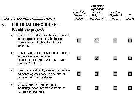
- a-d) The transfer property within McArthur-Burney Falls State Park contains
- four archaeological sites, one historic site (Burney Falls cemetery), and one multi-component site. Additionally, the park is within the Lake Britton Archeological District, which is listed on the NRHP. As discussed in the Project Description, no change in the management or public use of PG&Es lands within the State Park portion of the transfer is proposed. Additionally, no ground disturbing activities are proposed as part of the transfer within or near a previously recorded site. After the proposed transfer, the known archaeological and historical sites will be protected under the guidance of the existing McArthur-Burney Falls Memorial State Park General Plan and the regulations contained in Division 5 of the Public Resources Code. As a result, no change in the significance of a historical and/or archeological resource, destruction of a paleontological resource, or disruption of human remains is expected to occur as a result of the proposed project.
Bowman Ditch
The Bowman Ditch represents a historic landscape feature, constructed in the 1940s. Due to its age and historic use, this feature could potentially be documented as a historic resource and evaluated for its potential eligibility to the CRHP / NRHP. As part of the proposed project, the Bowman Ditch will be transferred to the DPR and be managed under the guidance of State Park regulations. Division 5, Chapter 1, Article 2 and Chapter 1.1.5, Articles 3 through 7 of the Public Resources Code set forth guidelines and practices for the management and continued preservation of cultural resources within State Park boundaries. Consequently, the transfer of fee title over the property to DPR would not result in a change of the significance of a historical, archeological, or paleontological resource, or result in the disturbance of any human remains.
Ahjumawi Property
No historical or archaeological sites have been previously recorded within this transfer property, however, 32 sites have been recorded within a ½-mile radius of the northern portion of the property. These consist of four historic sites, 22 prehistoric sites, and six sites with both an historic and a prehistoric component. Three of the prehistoric sites are immediately adjacent to the project parcel. With the substantial number of sites within close-proximity to the property, it is reasonable to assume that there could be undiscovered sites residing within the boundary of the property. This property is currently under the DPRs jurisdiction and all uses are subject to guidelines and policies contained within Division 5, Chapter 1, Article 2 and Chapter 1.1.5, Articles 3 through 7 of the Public Resources Code regarding the identification and protection cultural resources.
As a result of the transfer of fee title to PG&E and subsequently to CWA, the property would no longer be under DPRs jurisdiction or subject to regulations contained in Division 5 of the Public Resources Code. However, as mentioned in the Project Description of this document, there are no ground disturbing actions presently proposed for this property as a result of the land transfer, and the land would be protected under the proposed Conservation Easement and MSMP. Furthermore, the majority of the property is currently in a flooded state due to the failure of the Ahjumawi levy, and access to the area is limited. If, however, ground-disturbing activities are proposed in the future, guidelines contained within the proposed Conservation Easement and MSMP would require that an archaeological survey be conducted in consultation with the Ahjumawi Band of the Pit River Tribe to assess and mitigate any potential impacts to cultural resources. Therefore the transfer of fee title for this property would not result in a change of the significance of a historical, archeological, or paleontological resource, or result in the disturbance of any human remains and is not considered to be a significant impact.
McArthur Swamp and Glenburn Dredge Site
McArthur Swamp
- a-d) Five recorded archaeological sites reside within the boundary of the
- McArthur Swamp property and include the historic Rat Farm, three prehistoric lithic scatter sites (one of which also has groundstone artifacts), and a multi-component site with both prehistoric and historic material (Hart 2000). Additional cultural resource surveys were conducted as part of this environmental review for known areas of sensitivity where ground disturbing activities are proposed for habitat creation and restoration under the MSMP (see Figure V-1). As previously indicated, a large portion of McArthur Swamp area has not been surveyed, but archaeological sensitivity for prehistoric occupation sites is considered low along the northern and central portions of the property, since these areas were mainly inundated up until the twentieth century. Areas to the south, above the historic high water mark, however, are considered culturally sensitive.
Additionally, the levees, ditches, and canals within the McArthur Swamp potentially represent unrecorded historic resources. Due to their age and chronology of development (1860s to 1920s), it is likely that these features may be considered potentially eligible to the CRHP / NRHP as an historic landscape district. Any modification to the existing levees, ditches, and channels could alter the historical significance of these features, however, it is not anticipated that any of the proposed disturbance associated with the MSMP would result in a substantial adverse change in the significance of any historic resource as identified in Section 15064.5 of CEQA.
Currently, there are no known historic and/or archeological resources, as defined by Section 21084.1 of the CEQA Guidelines, located within areas expected to experience ground disturbing activities pursuant to the MSMP, including the Hollenbeck Field, Rat Farm Pond, Water Well, and the S2 and S1 reverse cycle wetland ponds. There is, however, the potential for such resources to be encountered during excavation activities in areas that are currently heavily vegetated. The greatest potential impact to archaeological and paleontological resources would occur as a result of construction-related activities from the implementation of habitat improvements associated with the MSMP. Excavation into an undiscovered resource could destroy portions of the site, disturb its integrity and context, unearth human remains, or impair the scientific value of the resource. This represents a potentially significant impact.
Impact V.1: Construction and/or excavation activities associated with the implementation of habitat improvements identified in the MSMP could encounter previously unidentified historic, archaeological, or paleontological resources. Excavation into an undiscovered resource could destroy portions of the site, disturb its integrity and context, unearth human remains, or impair the scientific value of the resource.
Mitigation Measure V.1a: Prior to the transfer of title of the McArthur Swamp, the applicant shall include specific language in the proposed Conservation Easement and MSMP requiring CWA to appoint a Professional Archaeologist (who is a member of the Registry of Professional Archaeologists), or Archaeologists, at least 15 days prior to the start of project-related vegetation clearance ground disturbance and grading, site or project mobilization, site preparation or excavation activities, implementation of erosion control measures, or movement or parking of heavy equipment or other vehicles onto or over unpaved or natural areas resulting from habitat improvements pursuant to the MSMP. The amended Conservation Easement and MSMP shall be submitted to the CPUC for review and approval prior to the transfer of title. As shall be specified in this new language, CWA shall provide the CPUC with the name(s) and statement of qualifications of its designated Professional Archaeologist (s) who will be responsible for implementation of all project-related cultural resources mitigation measures. The statement of qualifications must be sufficient to substantiate that the Archaeologist(s) meets the Secretary of the Interiors proposed Historic Preservation Qualification Standards as published in the Federal Register (United States Department of the Interior 1997).
At least 10 days prior to the start of any project-related activity defined above, CWA shall confirm in writing to the CPUC Mitigation Monitor that the approved designated Professional Archaeologist will be available at the start of project activities and is prepared to implement the protocol specified in the MSMP.
At least 10 days prior to the replacement of a designated Professional Archaeologist, CWA shall obtain the CPUC approval of the proposed replacement Professional Archaeologist.
Mitigation Measure V.1b: Prior to the transfer of title of the McArthur Swamp and Glenburn Dredge Site, the applicant shall amend the proposed Conservation Easement and MSMP to include specific language requiring that prior to the commencement of construction and/or ground disturbing activities, the designated Professional Archaeologist shall provide all construction personnel with environmental training in a manner that will inform them of the possibility of encountering cultural or historical resources. The amended Conservation Easement and MSMP shall be submitted to the CPUC for review and approval prior to the transfer of title. All construction personnel will be trained in the identification of archaeological resources (which could include flaked stone, projectile points, mortars, pestles, soil containing shell and bone, or human burials), historic resources (which could include stone features, such as adobe foundations or walls, structures and remains with square nails, and refuse deposits), human remains, and paleontological resources (which could include true and/or trace fossils). In addition, the construction personnel would be trained on the appropriate protocol to follow if any resources are found, as discussed in Mitigation Measures V.1c, V.1d, and V.1e.
Mitigation Measure V.1c: Prior to the transfer of title of the McArthur Swamp, the applicant shall amend the proposed Conservation Easement and MSMP to include specific language requiring that in the event that previously unidentified historic, archaeological, and/or paleontological resources are encountered during habitat improvement activities, the construction crew will halt work within a 100-foot radius of the find and not collect or disturb the materials until the Professional Archaeologist has evaluated the location and determined an appropriate mode of action. The amended Conservation Easement and MSMP shall be submitted to the CPUC for review and approval prior to the transfer of title. The Professional Archaeologist retained by CWA shall evaluate such resources for California Register of Historical Resources eligibility ensuring that the evaluations are supervised by individuals meeting the Secretary of the Interiors proposed Historic Preservation Qualification Standards (United States Department of the Interior 1997) for each particular resource type. An evaluation form shall be submitted to the CPUC, CWF, and the California Historical Resources Information Center. If the Professional Archaeologist determines that the resources are eligible for the California Register of Historical Resources, the Professional Archaeologist shall determine the appropriate action to be taken with preference given to preserving the resources in situ. If it is infeasible to be consistent with the objectives of the MSMP to leave the resources in place, the Professional Archaeologist shall conduct data recovery, if determined necessary to mitigate any significant project-related effects. If cultural resources are encountered during construction, Construction may resume once the Professional Archaeologist has determined (and implemented, if appropriate) an appropriate mode of action and has given the authorization to proceed.
Upon approval of this plan by the CPUC Mitigation Monitor, mitigation measures will be implemented prior to any project-related activities within 100 feet of the resources boundary.
Mitigation Measure V.1d: Prior to the transfer of title, the Conservation Easement and MSMP shall be amended to include language requiring CWA to notify a qualified paleontologist of unanticipated paleontological discoveries, made by either the Professional Archaeologist or construction personnel responding to their environmental training classes, and document the discovery as needed. In the event of an unanticipated discovery of true or trace fossil remains during construction, excavations within a 100-foot radius of the find shall be temporarily halted or diverted until the discovery is examined by a qualified paleontologist. The paleontologist shall notify the appropriate agencies to determine procedures that would be followed before construction is allowed to resume at the location of the find. Significant fossils shall be salvaged through a program of excavation, analysis, and documentation. Fossil remains collected during the salvage program shall be cleaned, sorted, catalogued, and then deposited in a public, non-profit institution with research interests in the materials. The amended Conservation Easement and MSMP shall be submitted to the CPUC for review and approval prior to the transfer of title.
Mitigation Measure V.1e: Prior to the transfer of title, the Conservation Easement and MSMP shall be amended to require CWAs contractors to immediately stop all work in the event human remains are found during the MSMPs activities within a 100-foot radius of the find. Following any such discovery, the Professional Archaeologist shall be notified immediately and will, in turn, immediately notify the Shasta County coroner, in compliance with Section 7050.5 of the California Health and Safety Code.
If the human remains are determined to be Native American in origin, the Shasta County coroner will notify the Native American Heritage Commission (NAHC) within 24 hours of the find. The most likely descendent shall be given an opportunity to make recommendations to the CWA and its contractors for means of treating or disposing of, with appropriate dignity, the human remains and any associated grave goods as provided in Public Resources Code Section 5097.98. Where conditions A, B, and/or C under Section 15064.5 (e) (2)occur, the landowner or authorized representative shall rebury the Native American human remains and associated grave goods with appropriate dignity on the property in a location not subject to further subsurface disturbance. The amended Conservation Easement and MSMP shall be submitted to the CPUC for review and approval prior to the transfer of title.
Mitigation Measure V.1f: Prior to the transfer of title, the Conservation Easement and MSMP shall be amended to require CWA to provide the opportunity for a Native American monitor, if interested, to be present on-site during project-related vegetation clearance, ground disturbance and grading, site or project mobilization, site preparation or excavation activities, implementation of erosion control measures, or the movement or parking of heavy equipment or other vehicles onto or over the project surface, within 500 feet of the boundary of known prehistoric resources and within 500 feet of the locations of modern and historic streams.
The Native American monitor shall be a member of the Ahjumawi Tribe Band of the Pit River Tribe and will serve in addition to the Professional Archaeologist. Monitoring by the cultural group representative is required within 500 feet of such sites. The amended Conservation Easement and MSMP shall be submitted to the CPUC for review and approval prior to the transfer of title.
Significance After Mitigation: Less than significant.
Glenburn Dredge Site
- a-d) As part of the cultural resource survey performed for this
- environmental assessment, a prehistoric site was recorded within this parcel, however its eligibility for inclusion on the NRHP is unknown at this time and the additional testing and excavation required to make this determination is unwarranted at this time, since no change to this area is anticipated with the project. Until such time as a determination can be made of the potential eligibility for inclusion on the NRHP for this prehistoric site or consider it a historical resource under CEQA, it must be considered potentially eligible and protected from further impact.
As part of FERCs recommendation as part of the Pit 1 Hydroelectric Project relicensing, a portion of the Glenburn Dredge Site has been proposed to be reopened for public access to the Fall River, with the installation of limited recreational facilities. This action has also been proposed as part of this project if the title transfer for the Glenburn site is approved. Therefore, the reopening of the public access is considered to be a reasonably foreseeable outcome of the proposed land transfer and has been considered in this document.
The reintroduction of public access to the site could potentially result in disturbance and a potential change in the significance of the newly discovered archaeological site and other potentially undiscovered resources on-site. Such an action could also expose the newly discovered site to potential vandalism and/or deterioration. This is considered a potentially significant impact.
Impact V.2: The reintroduction of public access to the Glenburn Dredge Site could result in a change in the significance of the newly discovered archaeological site and other potentially undiscovered resources on-site.
Mitigation Measure V.2: Prior to the transfer of title, the Conservation Easement shall be amended to include the a portion of the Glenburn Dredge Site property that is bounded by the fence required by this mitigation measure and the Fall River containing the newly discovered sensitive resource. The Conservation Easement shall include language requiring that the new owner establish permanent protection of sensitive resources. The amended Conservation Easement and MSMP shall be submitted to the CPUC for review and approval prior to the transfer of title. The new amended conservation easement including this portion of the Glenburn Dredge Site property shall restrict any uses of this area of the site portion of the parcel where the sensitive resource is present, except for the sole purpose of preserving the integrity of the sensitive resource. In addition, the Conservation Easement and MSMP shall be amended to include a requirement to reconfigure the existing fence layout at Glenburn to restrict access on and around sensitive resources. The re-establishment of public access at the southern portion of this parcel would remain feasible as proposed under the terms of this mitigation measure. Ultimately, the land area encumbered by the Conservation Easement and reconfigured fence layout would be determined according to the resource map outlined in the Cultural Resource Report, on file with the CPUC.
The Conservation Easement and MSMP, as amended, shall provide that a four strand barbed-wire fence be constructed effective to serve as an effective barrier to human and livestock access and shall be constructed at a location 100 feet from the boundary of the sensitive site or along the property line where it is closer than 100 feet from the boundary of the sensitive site (but not along the river). Construction of the fence shall comply with the protocols specified in Mitigation Measures V.1a-V.1f. The Conservation Easement and MSMP shall further be amended to provide for regular inspection and maintenance of the fence to ensure that it continues to be a barrier to access.
Significance After Mitigation: Less than significant.
REFERENCES
- Baumhoff, M. A., and D. L. Olmsted, 1963. Palaihnihan: Radiocarbon Support
- for Clottochronology and Archaeology. American Anthropologist 65(2):278-284.
- California Penal Code § 622.5.
- California Health & Safety Code §§ 7050.5(a) and 7052 et seq.
- California Health & Safety Code § 7000 et seq.
- California Health & Safety Code § 7050.5(c).
- California Public Resource Code §§ 5097.98(a), 5097.94.
- Callison, F. M., 1968. The Story of the McArthur Swamps. The Covered Wagon,
- pp 46-50. Shasta Historical Society, Redding.
- Department of Parks and Recreation, 1997. McArthur-Burney Falls Memorial
- State Park General Plan. State of California, Department of Parks and Recreation, Sacramento.
- Dixon, Roland B., 1908. Notes on the Achomawi and Atsugewi Indians of
- Northeast California. American Anthropologist Vol. 10:208-220.
- Garth, T. R., 1978. Atsugewi. In California, edited by R. F. Heizer,
- pp 236-243. Handbook of North American Indians, Volume 8, W. C. Sturtevant, general editor. Smithsonian Institution, Washington D.C.
- Hart, Daniel, 2000. Cultural Resources Inventory of Project Lands Upstream
- of the Pit 1 Forebay, Pit 1 Hydroelectric Relicensing Project (FERC No. 2687), Shasta County, California. Garcia and Associates, San Anselmo. Submitted to PG&E, Chico.
- Hull, Kathleen L., et al., 1999. Report of Enhanced Archaeological Survey for
- Pit No. 1 Relicensing Project, Shasta County, California: Additional Survey of Lands Outside of the Relicensing Area of Potential Effects.
- Kelly, M. S., E. Nilsson, and J. H. Cleland, 1987. Archaeological Investigations
- at Lake Britton, California: Pit 3, 4 and 5 Project (License No. 233) Archaeological Site Testing
. WIRTH Environmental Services, San Diego. Submitted to PG&E, San Francisco.
- Kniffen, Fred B., 1928. Achomawi Geography. University of California
- Publications in Anthropology, Archaeology, and Ethnology
23(5):297-332. Berkeley.
- Kroeber, A. L. 1925. Handbook of the Indians of California. Dover
- Publications, Inc., New York.
- Maniery, M., J. Barton, and C. Baker, 2000. National Register of Historic
- Places Evaluation Pit River 3, 4, and 5 Hydroelectric System, Shasta County, California. PAR Environmental, Sacramento. Submitted to Pacific Gas & Electric Company, San Francisco.
- Manuel, Don, 1983. Test Excavations at LAS-973, a Severely Vandalized
- Site in Northwestern Lassen County California. Paper presented at the 17th Annual Meeting of the Society for California Archaeology.
- Merriam, C. Hart, 1926. The Classification and Distribution of the Pit River
- Tribes of California. Smithsonian Miscellaneous Collections 78(3):1-52. Washington D.C.
- Neasham, Ernest R, 1957. Fall River Valley: An Examination of Historical
- Sources. The Citadel Press, Sacramento.
- Olmsted, D. L., and Omer C. Stewart, 1978. Achumawi. In California, edited
- by R. F. Heizer, pp 225-235. Handbook of North American Indians, Volume 8, W. C. Sturtevant, general editor. Smithsonian Institution, Washington D.C.
- Peak & Associates, 1984. Cultural Resources Study for the Pit 3, 4, 5
- FERC-233 Project, Shasta County, California. Peak & Associates, Inc., Sacramento. Submitted to Pacific Gas & Electric Company, San Francisco.
- Pit River Tribe, 2001. Consultation Letter: Comments on April 3, 2001
- Meeting regarding McArthur Swamp. June 13, 2001.
- Shasta County Department of Resource Management, 1998. Shasta County
- General Plan, October 1998, Redding.
- Smith, Dottie, 1991. The Dictionary of Early Shasta County History. D. Smith,
- Cottonwood.
- Vaughan, Trudy, 2001. Archaeological Reconnaissance of Proposed Impact
- Areas for PG&E's Proposed McArthur Swamp Land Exchange, Shasta County, California. Coyote & Fox Enterprises, Redding. Submitted to Environmental Science Associates, Sacramento.