


PG&E Land Transfers Final Mitigated Negative Declaration
Section 2-VI Geology and Soils
Previous | Next Section

SETTING
Burney Falls, Bowman Ditch, and Ahjumawi Property
The Fall River Valley and McArthur-Burney Fall Memorial State Park are located at the southern end of the Cascade Range within the Modoc Plateau Geomorphic province. This area lies along the northwestern-most flank of the Sierra Nevada Geomorphic Province. The Modoc Plateau is characterized as a transitional region between the Basin and Range Geomorphic Province to the east and the Cascade Range Geomorphic province to the west and north. According to available geologic maps from the California Division of Mines and Geology (CDMG), the Modoc Plateau is underlain by Tertiary sediments and recent volcanic rocks that have been block-faulted into north trending ranges, which have resulted in large open valleys. The plateaus block faulting is believed to be related to Basin and Range faulting in a terrain immersed by volcanic rocks (CDMG, 1966). The plateau is capped with scattered small, young cinder cones and basalt flows. Typical rock formations in the area include volcanic breccia, mud and ash flows, lava flows, lacustrine (lake) deposits, and cinder cone pyroclastic rocks.
Burney Falls
The western portions of Burney Falls are underlain by Pliocene nonmarine sedimentary rock, comprised chiefly of diatomite, which was deposited in a lacustrine setting. The eastern portion of the property is underlain by Plio-Pleistocene olivine basalt flows such as those exposed by the falls on Burney Creek (CDMG, 1994).
Several Quaternary and Holocene faults are located within a 60-mile radius of the site. Five Holocene Faults including the McArthur, Mayfield, Pittville, Hat Creek, and Rocky Ledge faults are all located within 20 miles of the property. The Rocky Ledge fault trends northwesterly about three miles to the south of the transfer property (CDMG, 1994). With the close-proximity of numerous faults, these sites within the Park could potentially be subjected to ground motion from displacement along any of these local and regional faults. Additionally, the Burney Falls area could be affected by regional volcanic events originating within the Mt. Shasta, Lassen Peak, or Medicine Lake volcanic centers, all of which have experienced activity within the last 500 years (CDMG, 1994).
The transfer property within the State Park is located on two constituent soil types. These include the Britton Silt Loam, 30 to 50 percent slopes and Burney-Arkright Complex, two to nine percent slopes mapping units. Britton Silt Loams, 30 to 50 percent slopes soils are characterized as being relatively shallow (10 to 20 inches), and well drained with moderately slow permeability. These soils have formed in dissected lacustrine terraces from alluvium derived from diatomite lacustrine deposits (NRCS, 2000). They have a moderate to high hazard of erosion by water and a low to moderate erosion hazard from wind in exposed, bare areas (refer to Table VI-1). These soils are classified as having a moderate shrink-swell potential[1] and are classified as having a Capability Class rating of IV, due to the high hazard of erosion and they are not considered Prime Farmland.
Soils comprising the Burney-Arkright Complex, two to nine percent slopes mapping unit, occupy smaller areas in the eastern portion of the transfer property and are underlain by basaltic lava flows. These soils are relatively deep (40 to 60 inches), well drained gravelly loams with moderately slow permeability. This mapping unit is typically found at the base of toe slopes where alluvium from basalt has been deposited. The soil lacks a substantial proportion of clay and therefore, has a low shrink-swell potential (refer to Table VI-1). Water erosion hazard for bare soil is low to moderate, while the wind erosion hazard is low (refer to Table VI-1). These soils have a Capability Class rating of III to IV, due to erosion hazards and are not considered to be Prime Farmland (NRCS, 2000).
Bowman Ditch
The Bowman Ditch and adjacent area are underlain by Quaternary lacustrine deposits composed of alluvial sediments derived from volcanic materials, water-lain ash deposits, and local diatomaceous detritus (CDMG, 1968). As with the State Park, several Quaternary and Holocene faults are located within a 60-mile radius of the drainage way. Holocene faults such as the, McArthur, Mayfield, Pittville, Hat Creek, and Rocky Ledge faults are located within a 20-mile radius of the site. The McArthur fault is mapped as trending in a northwesterly direction about three miles northeast of the site between Big Lake and Horr Pond (CDMG, 1994). This property could potentially be subjected to ground motion from displacement along any of these local and regional faults. In addition, the Bowman Ditch and surrounding area are located within an area that could be affected by regional volcanic events originating within the Mt. Shasta, Lassen Peak, or Medicine Lake volcanic centers, all of which have experienced activity within the last 500 years (CDMG, 1994).
The Bowman Ditch is located on soils mapped as the Pastolla Muck, drained, zero to two percent slopes. These soils are very deep (greater than 60 inches), very poorly drained, and mucky with slow permeability. The exception to this is where the natural drainage regime is altered, as is the case for areas immediately adjacent to the channeled ditch. The ditch was originally channeled out to increase flows to the Tule River for the Pit River Hydroelectric Project. These soils developed in basins from stratified alluvium of ash and lacustrine deposits. They have a low hazard of erosion by water and a moderate erosion hazard from wind in exposed, bare areas. The soils are moderately to strongly alkaline and have a very high shrink-swell potential (refer to Table VI-1). They have a Capability Class rating of IV and are not considered to be Prime Farmland (NRCS, 2000).
Ahjumawi Property
The Ahjumawi Property is located immediately adjacent to the southeast of the Bowman Ditch and therefore the subsurface is comprised of similar alluvial sediments and water-lain ash deposits. As with the Bowman Ditch, the Ahjumawi Property is located in a seismically active region with numerous, previously referenced faults and volcanoes situated in the immediate vicinity.
Soils located on the Ahjumawi Property consist of the Pastolla muck, 0 to 1 percent slopes, which are similar to those located along the Bowman Ditch, except that it is not artificially drained (NRCS, 2000). This area is currently inundated due to the lack of maintenance of the levee along the southern boundary of the property. Consequently, these soils will continue to remain submerged on an annual basis.
McArthur Swamp and Glenburn Dredge Site
The McArthur Swamp and the Glenburn Dredge Site are located within the same regional geographical area and geomorphic province as the McArthur-Burney Falls Memorial Park. These two locations are located approximately 30 miles east of the Park and less than a mile south of the Bowman Ditch and Ahjumawi Property.
McArthur Swamp
The majority of the PG&E property is underlain by Quaternary Lake deposits comprising alluvial sediments derived from volcanic lands and water-lain ash deposits. Areas along the northeastern shores of Big Lake are mapped as Recent Modoc basalt flows (CDMG, 1968). As discussed under the Bowman Ditch subheading, numerous faults are located in the immediate vicinity of the McArthur Swamp. These mapped faults include the McArthur, Mayfield, Pittville, Hat Creek, and Rocky Ledge faults; whereby the McArthur fault trends northwesterly through the site between Big Lake and Horr Pond (CDMG, 1994). Since the active McArthur fault traverses the site, any displacement along this segment of the fault could result in potential fault rupture at the surface. In addition, the McArthur Swamp area could be affected by regional volcanic events originating within the Mt. Shasta, Lassen Peak, or Medicine Lake volcanic centers, all of which have had activity within the last 500 years (CDMD, 1994).
According to the Soil Survey for the Intermountain Area of California, ten soil mapping units have been delineated within the vicinity of the McArthur Swamp Property (see Table VI-1). The actual distribution of these ten mapping units is complex, and therefore, will be described by bisecting the site into two northern quadrants and a southern half. Some soils are found in each property while others are more or less restricted to one portion of the property.
The Pastolla Muck, drained, 0 to 2 percent slopes and Pastolla muck, 0 to 1 percent slopes occupy a large portion of the area of the northern quadrants along the Tule River. These soils also occupy smaller areas along Fall River in the southern half of the property. These soils are very similar to those discussed for the Bowman Ditch and Ahjumawi Property. The only significant difference is attributed to the continued maintenance of the McArthur Levee, which has kept these soils drained and suitable for grazing.
Areas in the central portion of the northern half of the property contain the Henhill Silt Loam, partially drained, 0 to 2 percent slopes mapping unit. These soils contain a very deep profile and are somewhat poorly drained with moderately slow permeability. They are derived from lake sediments and alluvium, which formed from extrusive igneous rocks. Henhill Silt Loams are classified as neutral to slightly alkaline and have moderate shrink-swell potential. The water erosion hazard on these soils is low, while the wind erosion hazard is moderate, due to the high percentage of silt (refer to Table VI-1). They have a Capability Class rating of II and are classified as Prime Farmland when properly drained and irrigated (NRCS, 2000).
The Lava Flows-Gassaway Complex, 2 to 15 percent slopes map unit is found along the northeastern shoreline of Big Lake at the northeastern edge of the site. Gassaway soils occur approximately 30 percent of the complex and have formed from eolian deposits in pockets of the broken Lava Flow lands. They are shallow, well drained cobbly loams of moderate permeability and are neutral to mildly acidic. They have a low shrink-swell potential, low to moderate water erosion hazard, and a low wind erosion hazard in bare areas (see Table VI-1). Gassaway soils have a Capability Class rating of VIII and are not considered Prime Farmland. Recent lava flows comprise approximately 60 percent of this complex and are characterized by sharp, jagged, broken blocks piled in tumbled heaps and have many crevices, sinkholes, and collapsed lava tubes. Most areas are vegetated by such plants as western juniper, ponderosa pine, antelope bitterbrush, manzanita, and Modoc cypress. However some areas are virtually devoid of vegetation, due to deficient nutrient supplies (NRCS, 2000).
The southern portion of the McArthur Swamp property is comprised of numerous soil mapping units, which include the Cupvar, Whipp, Pittville, Dugan, and Graven soil series. The Whipp-Cupvar Complex, 0 to 2 percent slope soils occupy the central, northern portion of the southern half of the site. Whipp soils account for approximately 60 percent of these map units, while Cupvar soils account for approximately 25 percent. These soils formed in basins of mixed alluvium and are moderately deep, poorly drained soils with slow permeability and a high shrink-swell potential (see Table VI-1). They have a low erosion hazard from water when bare and a moderate hazard from wind erosion. The soils are moderately to strongly alkaline. The soils have a Capability Class rating of IV and are not considered Prime Farmland. They are associated with the Whipp-Cupvar Complex, slightly saline, 0 to 2 percent slopes mapping unit which occupies a flanking position to the south. Except for being more saline, these latter soils have very similar characteristics as shown in Table VI-1 (NRCS, 2000).
Soils of the Cupvar Silty Clay, 0 to 2 percent slopes mapping unit are located in the central portion of the southern half of the site. These soils are also basin soils and formed from alluvium derived from extrusive igneous rock. These soils are moderately deep, moderately well drained and have slow permeability. They have a high shrink-swell potential and have a low water erosion hazard and low wind erosion hazard when bare (see Table VI-1). The soils are not considered Prime Farmland and have a Capability Class rating of IV (NRCS, 2000).
Three remaining mapping units are located in a band along the southern portion of the property and include the Dugan-Graven Complex, Flooded, 0 to 5 percent slopes, Dugan-Graven Complex, 0 to 5 percent slopes, and the Pittville Sandy Loam, 0 to 5 percent slopes occupy this area. Dugan and Graven soils are comprised of soils formed on mounds and stream terraces from alluvium of extrusive igneous rocks. They are shallow, moderately well drained soils with slow permeability and have a high shrink-swell potential (see Table VI-1). They have a low hazard from water and wind erosion when exposed. These soils have a Capability Class rating of III to IV and are considered Prime Farmland when irrigated (NRCS, 2000).
Soils of the Pittville Sandy Loam, 0 to 5 percent slopes mapping unit occur at the southern fringe of the site. These soils formed on stream terraces from alluvium derived from extrusive igneous rocks. The soils are very deep, well drained soils with moderately slow permeability and have a moderate shrink-swell potential (see Table VI-1). They have a moderate hazard for water and wind erosion when bare. They have a Capability Class rating of II and are considered Prime Farmland when irrigated (NRCS, 2000).
Glenburn Dredge Site
Soils at the property have been mapped as the Pit Silty Clay, Drained, 0 to 2 percent slopes mapping unit. These soils formed in basins from fine-textured alluvium from extrusive and basic igneous rock. They are very deep, poorly drained soils with slow permeability and a high shrink-swell potential (see Table VI-1). Their hazard for water and wind erosion is none to low when bare. They have a Capability Class rating of IV and are considered Prime Farmland if drained and irrigated (NRCS, 2000).
REGULATORY SETTING
State Regulatory Oversight
Alquist-Priolo Geologic Hazards Zone Act
The Alquist-Priolo Earthquake Fault Zoning Act (formerly the Alquist-Priolo Special Studies Zone Act), signed into law December 1972, requires the delineation of zones along active faults in California. The purpose of the Alquist-Priolo Act is to regulate development on or near active fault traces to reduce the hazard of fault rupture and to prohibit the location of most structures for human occupancy across these traces.[2] Cities and counties must regulate certain development projects within the zones, which includes withholding permits until geologic investigations demonstrate that development sites are not threatened by future surface displacement (Hart, 1997). Surface fault rupture is not necessarily restricted to the area within an Alquist-Priolo Zone.
As indicated by Special Publication 42, Fault-Rupture Zones in California, each of the transfer properties are located in areas with delineated fault-rupture zones. The Burney Falls properties are located to the northwest of the Rocky Ledge Fault-Rupture Zone. The McArthur Swamp, Bowman Ditch, and the Ahjumawi Property are located within or adjacent to the McArthur Fault-Rupture Zone.
Seismic Hazards Mapping Act
The Seismic Hazards Mapping Act was developed to protect the public from the effects of strong groundshaking, liquefaction, landslides, or other ground failure, and from other hazards caused by earthquakes. This act requires the State Geologist to delineate various seismic hazard zones and requires cities, counties, and other local permitting agencies to regulate certain development projects within these zones. Before a development permit is granted for a site within a seismic hazard zone, a geotechnical investigation of the site has to be conducted and appropriate mitigation measures incorporated into the project design. As discussed in Section 1.0, Project Description, no development is proposed that would eventually be utilized for human occupancy. Therefore, the Shasta County Building division would not be required to issue a development permit.
County Regulatory Oversight
The Shasta County General Plan contains a Public Safety Element as required by Section 65302(g) of the California Government Code, which requires that General Plans include an element containing identification and appraisal of seismic and geologic hazards. Seismic hazards addressed by this element include surface faulting, ground shaking, and ground failure. Non-seismic hazards addressed in the document include volcanoes, erosion, and expansive soils. The Shasta County General Plan provides the following policies for properties outside of the FERCs jurisdiction as they relate to seismic and geologic hazards:
Policy SG-c - Shasta County shall coordinate with state and federal agencies monitoring volcanic activity and shall periodically review and update the Shasta County Emergency Plan with respect to volcanic hazards.
Policy SG-d - Shasta County shall develop and maintain standards for erosion and sediment control plans for development. Special attention shall be provided to erosion prone hillside areas, including extremely erodible soils types such as those evolved from decomposed granite.
Policy SG-e - When soil tests reveal the presence of expansive soils, engineering design measures designed to eliminate or mitigate their impacts shall be employed.
Policy SG-f - Shasta County shall pursue preparation of development standards based on topography and soil erosion potential in revising its land capability standards pursuant to Policy CO-h.
Policy SG-g - Shasta County should comply with the requirements of the Seismic Hazards Mapping Act, when the Seismic Hazards Maps for the County are completed and made available by the State Geologist. The Maps will include liquefaction hazard zones and earthquake-induced landslide hazard zones.
Geology and soils impact discussion
- Each of the proposed transfer properties are located within a seismically active region and could experience significant groundshaking and/or earthquake induced landslides resulting from displacement along one of the following Holocene Faults including the, McArthur, Mayfield, Pittville, Hat Creek, and Rocky Ledge faults. Additionally, each of the properties lie within or adjacent to an Alquist-Priolo Fault-Rupture Study Zone. Furthermore, each of the properties would be subject to regional volcanic events originating from the previously discussed volcanoes.
As indicated in the Project Description, no substantial construction or physical modifications to structures located at the McArthur-Burney Falls Memorial State Park, Bowman Ditch, and Ahjumawi property are proposed in connection with the transfer of ownership. Following the exchange, Burney Falls and Bowman Ditch will be protected from major construction and other soil disturbing activities by the legal restrictions applicable to State parklands. Further, DPR is bound by its General Plan with respect to Burney Falls and must conduct a CEQA review for any activities which deviate from the approved plan. Ground disturbing activities are prohibited on the Ahjumawi Property by the deed restrictions contained within the Conservation Easement, which will coincide with the property. Therefore, the transfer would not expose people or structures to potential substantial adverse effects, including the risk of loss, injury, or death. This is considered a less-than-significant impact.
Activities planned for the McArthur Swamp after the ownership transfer would not differ substantially from historic activities undertaken in the area since site reclamation earlier in the century. These activities include periodic maintenance of levees and roadways, recreational use, and grazing. Should one of the local faults in the area experience displacement, the McArthur Swamp could potentially experience levee failures from ground lurching and/or lateral spreading. Additionally, the banks of the levees could experience localized landslides and slumps. Furthermore, the McArthur Fault bisects the property and is designated as an Alquist-Priolo Fault-Rupture Study Zone. However, each of the proposed uses would not expose people or new structures to potential substantial adverse effects, including the risk of loss, injury, or death. Therefore, a less-than-significant impact is expected.
- The proposed project involves no earthwork at the Burney Falls, Bowman Ditch, and Ahjumawi Properties. Therefore, aside from naturally occurring erosional processes, no impact is anticipated.
On the McArthur Swamp property, grading activities involved with the construction and development of wetland habitat at the Hollenbeak and Ash fields would have the potential to cause accelerated erosion, unless proper erosion control measures are implemented. Levee improvements and associated road maintenance necessary for delivery of imported fill would also cause temporary disturbances to the topsoil surfaces. These disturbances could cause increased dust generation, siltation caused by placement of large aggregate on the waterside of levees, local soil compaction caused by equipment loads, and exposure of mineral soil surfaces to erosion. Adherence to appropriate engineering, design, and construction practices, such as dust control, seasonal considerations, and rapid revegetation, would minimize impacts involving these improvements at the McArthur Swamp property, resulting in a less than significant impact.
Statutes such as Section 404 of the Clean Water Act and other federal and state regulations require an erosion and sedimentation control plan prior to major construction. As indicated by PG&E in their PEA, wetland construction work will be completed under a USACOE Nationwide No. 27 Permit, which requires agreement with the USFWS and a water certification or waiver. Additionally, the recontouring of the Hollenbeck field and excavation of three ponds in the S-field would be considered a major construction / excavation activity and would disturb over 10,000 square feet of surface area. As a result, the applicant will be required to obtain a grading permit from the Shasta County Environmental Health Department consistent with the Shasta County Grading Ordinance. Adherence to standard grading practices as required by the grading permit would ensure that the impacts from erosion would be less-than-significant. The County Environmental Health Department would act as the monitoring body to ensure compliance with the permit.
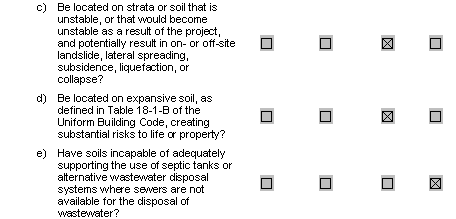
- As described under item (a), while various areas of the project site do consist of unstable soils, there are no facilities proposed as part of the project which have the potential to be impacted by these soils, therefore this is a less than significant impact.
- As indicated in Table VI-1, each of the transfer properties would contain, to some degree, expansive soils, as defined in Table 18-1-B of the Uniform Building Code. However, as indicated in the Project Description, the land transfers would not involve the construction of any inhabitable structures. Therefore, the proposed land transfers would not create a substantial risk to life or property. As a result, less-than-significant impact is expected.
- There are no septic tanks or wastewater disposal systems proposed as part of this project, therefore this item is not applicable.
REFERENCES
- CDMG, 1966. California Division of Mines and Geology. 1966. Geology of
- Northern California, Bulletin 190.
- CDMG 1968. California Division of Mines and Geology. 1968. Geologic Map
- of California, Alturas Sheet. Scale 1:250,000.
- CDMG, 1994. California Division of Mines and Geology. 1994. Geologic
- Data Map No. 6, Fault Activity Map of California and Adjacent Areas with Locations and Ages of Recent Volcanic Eruptions. Scale 1:750,000.
- Shasta County, 1999. Shasta County General Plan, Resource Element.
- FEMA. 1985. Flood Insurance Map Community Panel No. 060358-0150B.
- September 27.
- Hart, 1997. Fault-Rupture Hazard Zones in California: Alquist-Priolo Special
- Studies Zones Act of 1972 with Index to Special Studies Zones Maps, California Division of Mines and Geology, Special Publication 42, 1990, revised and updated 1997.
- NRCS, 2000. Soil Survey of Intermountain Area, California, Parts of Lassen,
- Modoc, Shasta, and Siskiyou Counties. Natural Resources Conservation Service. In cooperation with the Regents of the University of California (Agricultural Experiment Station); United States Department of Agriculture, Forest Service; California Department of Forestry, Soil Vegetation Survey; and United States Department of the Interior, Bureau of Land Management.
Footnotes
- "Shrink-swell" is the cyclical expansion and contraction that occurs in fine-grained clay sediments from wetting and drying. Structures located on soils with this characteristic may be damaged over a long period of time, usually as the result of inadequate foundation engineering.[back]
- A "structure for human occupancy" is defined by the Alquist-Priolo Act as any structure used or intended for supporting or sheltering any use or occupancy that has an occupancy rate of more than 2,000 person-hours per year.[back]